METAR & TAF KMFR
Current METAR
Observed 15:53Z
KMFR 271553Z VRB04KT 10SM CLR 20/11 A3008 RMK AO2 SLP175 T02000106
- Wind
- VAR @ 4 kt
- Visibility
- 10 SM
- Temp / Dew
- 20°C / 11°C
- Altimeter
- 30.08 inHg
- Clouds
- CLR
- Density alt
- 2,057 ft
- Ceiling
- Unlimited
- Rules
- VFR
Airport info & contacts
Manager on record, flight service, ARTCC, attendance schedule and pattern altitude — published by the FAA and refreshed every 28 days.
Location
- From city
- 3 NM N
- VFR sectional
- KLAMATH FALLS
- Pattern altitude
- 969 ft AGL · 2,304 ft MSL
- ARTCC
- ZSE · SEATTLE
- NOTAM facility
- MFR (NOTAM-D)
Airport manager
- Name
- AMBER JUDD
- Phone
- 541-776-7222
- Address
- 1000 TERMINAL LOOP PKWY, STE 201, MEDFORD OR 97504
Flight service · Hours
- FSS MMV
- MC MINNVILLE1-800-WX-BRIEF
- Attendance
- 0500-2400
Frequencies
Tap any row to copy the frequency to your clipboard.
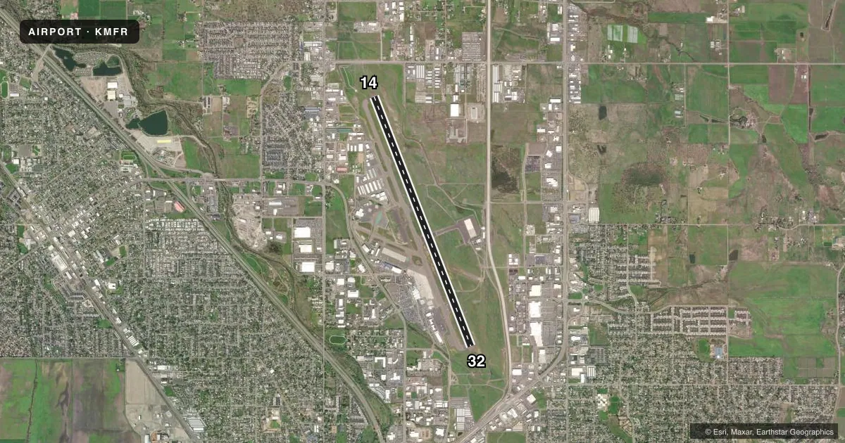
Runways & pattern
Full pagePattern entry · RWY 32
LEFT TRAFFICRunway end performance
| End | TORA | TODA | ASDA | LDA | VGSI | Approach lights | Obstruction |
|---|---|---|---|---|---|---|---|
| 14 | 8,800' | 8,800' | 8,800' | 8,800' | PAPI 4-box left(3°) | MALSR | — |
| 32 | 8,800' | 8,800' | 8,800' | 8,800' | PAPI 4-box right(3°) | — | — |
Declared distances in feet. TORA = takeoff run available, TODA = takeoff distance, ASDA = accelerate-stop, LDA = landing distance.
Airport sketch
Runways drawn to scale from FAA survey coordinates, rendered over satellite imagery. Not for navigation.
Approaches & charts
ILS · 1
Services on the field
Fuel grades, oxygen, maintenance, ramp storage and lighting — as declared to the FAA by the airport operator.
Fuel & services
- Fuel
- 100LLAA+
- Oxygen (bottled)
- High pressure
- Airframe repair
- Major
- Power plant repair
- Major
- Other services
- AFRT,AMB,AVNCS,CARGO,INSTR,SALES
Ramp & ground
- Transient storage
- Tie-down
- Hangar
- Landing fee
- Yes
- Customs
- Not available
- Lighting schedule
- SEE RMK
- Beacon schedule
- SS-SR
- Beacon
- White / Green (civil land)(WG)
- Wind indicator
- Lighted
- Segmented circle
- Yes
Fuel & FBOs
Cheapest 100LL and Jet A on the field and nearby. Always confirm with the FBO before taxi.
Airport notes
Surface conditions, obstructions, local procedures, lighting outages and other notes published with each FAA cycle.
General notes
- WATERFOWL INVOF ARPT NOV-MAY.
- TRML APRON CLSD EXCP SKED ACR & PPR.
- TSNT TIE DOWN & HNGR AVBLTY - FBO.
- SFC COND UNMNT 2400-0400.
- COLD TEMPERATURE AIRPORT. ALTITUDE CORRECTION REQUIRED AT OR BELOW -2C.
- FOR CD IF UNA TO CTC ON FSS FREQ, CTC SEATTLE ARTCC AT 253-351-3694.
- FUEL AFT HR - 541-842-2254.
- PILOTS CONDUCTING EFVS OPS; BE AWARE LED ALS IN USE RWY 14.
Lighting notes
- ACTVT MALSR RWY 14; REIL RWY 32; TDZ RWY 14; CNTRLN LGTS RWY 14/32; PAPI RWY 14 & 32; HIRL RWY 14/32; TWY LGTS - CTAF.
Runway surface & condition
- 14/32PCR VALUE: 1110/F/D/X/T
Approach & departure obstructions
- 32PAPI RWY 32 DOES NOT PRVD OBS CLNC BYD 6.5 NM FM THR.
Other notes
- PPR FOR UNSKED OPS GTR THAN 30 PAX SEATS - 541-776-7228.
- 969 FT AGL FOR PROP ACFT; 1469 FT AGL FOR TURBO ACFT.
- CORPORATE & GTR THAN 12500 LB LNDG FEE.
VFR map & nearby airports
VFR sectional. Tap any ICAO chip to open that airport.
Key facts · KMFR
Answer card- ICAO
- KMFR
- Name
- ROGUE VALLEY INTL/MEDFORD
- Location
- MEDFORD, OREGON
- Elevation
- 1,335.3 ft MSL
- Traffic pattern altitude
- 2,304.3 ft MSL (969 AGL)
- Control tower
- Towered · 0600-2100
- Total runways
- 1
- Longest runway
- 14/32 · 8,800 ft
- Published ILS approaches
- 1
- Published frequencies
- 10
- Magnetic variation
- 16°
- Current flight rules
- VFR
- Current wind
- 000° at 4 kt
- Favored runway now
- RWY 32
Rogue Valley Intl/Medford sits in Medford, Oregon at 1,335.3 ft MSL. It has one runway. Runway 14/32 is 8,800 ft long and paved with asphalt. The airport is towered from 0600 to 2100. One ILS is published for runway 14. Pattern altitude is 969 ft AGL, which is 2,304.3 ft MSL for propeller aircraft. Turbo aircraft use 1,469 ft AGL. The field sits in a busy southern Oregon valley. Check the current chart and listen up for local traffic flow before you arrive.
Million Air Medford is on the field. It carries 100LL, Jet A and Jet A Prist. Fuel is available after hours by calling the FBO. The published remarks also note LED approach lighting on runway 14, centerline lights on both runways and PAPI on both ends. Runway 32 has a PAPI limitation beyond 6.5 NM from the threshold. The airport is a cold temperature field, so altitude correction is required at or below minus 2 degrees Celsius. Waterfowl are also reported in the area from November through May. The terminal apron is closed except for scheduled aircraft and prior permission required operations. Pilots should verify any ramp access or landing fee details with the airport operator before arrival.