METAR & TAF S03
S03 does not publish a METAR.
Showing the nearest reporting station: KMFR (ROGUE VALLEY INTL/MEDFORD) · 14.6 NM away. Conditions at S03 may differ.
METAR · KMFR
Observed 12:53Z
KMFR 271253Z 00000KT 10SM CLR 16/08 A3006 RMK AO2 SLP168 T01560078
- Wind
- 000° @ 0 kt
- Visibility
- 10 SM
- Temp / Dew
- 16°C / 8°C
- Altimeter
- 30.06 inHg
- Clouds
- CLR
- Density alt
- 2,288 ft
- Ceiling
- Unlimited
- Rules
- VFR
Airport info & contacts
Manager on record, flight service, ARTCC, attendance schedule and pattern altitude — published by the FAA and refreshed every 28 days.
Location
- From city
- 2 NM E
- VFR sectional
- KLAMATH FALLS
- Pattern altitude
- 1,015 ft AGL · 2,904 ft MSL
- ARTCC
- ZSE · SEATTLE
- NOTAM facility
- MMV (NOTAM-D)
Airport manager
- Name
- ROBERT SKINNER
- Phone
- 541-482-7675
- Address
- 403 DEAD INDIAN MEMORIAL ROAD, ASHLAND OR 97520
Flight service · Hours
- FSS MMV
- MC MINNVILLE1-800-WX-BRIEF
- Attendance
- OCT-APR · MON-SAT · 0800-1700
- MAY-SEP · MON-SAT · 0800-1800
- SUN · 0900-1700
Frequencies
Tap any row to copy the frequency to your clipboard.
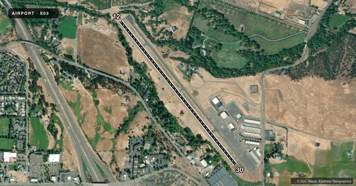
Runways & pattern
Full pagePattern entry · RWY 12
LEFT TRAFFICRunway end performance
| End | TORA | TODA | ASDA | LDA | VGSI | Approach lights | Obstruction |
|---|---|---|---|---|---|---|---|
| 12 | — | — | — | — | PAPI 2-box left(3.75°) | — | 12', road, 240' from thr, 0' R of cntrln, slope 3 |
| 30 | — | — | — | — | PAPI 2-box right(4°) | — | 55', trees, 355' from thr, 80' R of cntrln, slope 2 |
Declared distances in feet. TORA = takeoff run available, TODA = takeoff distance, ASDA = accelerate-stop, LDA = landing distance.
Airport sketch
Runways drawn to scale from FAA survey coordinates, rendered over satellite imagery. Not for navigation.
Approaches & charts
Services on the field
Fuel grades, oxygen, maintenance, ramp storage and lighting — as declared to the FAA by the airport operator.
Fuel & services
- Fuel
- 100LLA
- Oxygen (bottled)
- Low pressure
- Oxygen (bulk)
- Not available
- Airframe repair
- Major
- Power plant repair
- Major
- Other services
- CHTR,INSTR,RNTL,SURV
Ramp & ground
- Transient storage
- Tie-down
- Landing fee
- No fee published
- Customs
- Not available
- Lighting schedule
- SEE RMK
- Beacon schedule
- SS-SR
- Beacon
- White / Green (civil land)(WG)
- Wind indicator
- Lighted
- Segmented circle
- Yes
Fuel & FBOs
Cheapest 100LL and Jet A on the field and nearby. Always confirm with the FBO before taxi.
Airport notes
Surface conditions, obstructions, local procedures, lighting outages and other notes published with each FAA cycle.
General notes
- RY 12 HAS 165 FT TERRAIN 5000 FT AT 29:1.
- DEER & BIRDS ON & INVOF ARPT
- 24 HR CREDIT CARD FUEL AVBL.
- TAXILANE WIDTH IN VCNTY HANGARS: 36 FEET FROM CENTER.
- FOR CD CTC CASCADE APCH AT 541-607-4674/4675, WHEN APCH CLSD CTC SEATTLE ARTCC AT 253-351-3694.
Lighting notes
- ACTVT MIRL RY 12/30, & REIL RY 30 - CTAF. PAPI RYS 12 & 30 OPR 24 HRS.
Approach & departure obstructions
- 12+40 FT TREE 110 FT FM RY END 100 FT R.; 9' BRIARS AT 0-200' FROM RUNWAY END AND 60-125' RIGHT OF CENTER LINE.
- 309' BRIARS AT 0-200' FROM RUNWAY END AND 80-125' LEFT OF CENTERLINE.
- 30RWY 30 +110 FT TREES AT 1420 FT, 150 FT R, 13:1 BASED ON DTHR. 55 FT TREES AT 505 FT, 125 L OF CNTRLN, 9:1 BASED ON DTHR.
Other notes
- AUTOMATED UNICOM.
VFR map & nearby airports
VFR sectional. Tap any ICAO chip to open that airport.
Key facts · S03
Answer card- ICAO
- S03
- Name
- ASHLAND MUNI/SUMNER PARKER FLD
- Location
- ASHLAND, OREGON
- Elevation
- 1,888.5 ft MSL
- Traffic pattern altitude
- 2,903.5 ft MSL (1,015 AGL)
- Control tower
- Non-towered (use CTAF)
- Total runways
- 1
- Longest runway
- 12/30 · 3,603 ft
- Published ILS approaches
- 0
- Published frequencies
- 4
- Magnetic variation
- 18°
- Current flight rules
- VFR
- Current wind
- 000° at 0 kt
- Favored runway now
- –
Ashland Muni/Sumner Parker Fld sits in Ashland, Oregon at 1,888.5 ft MSL. It has one asphalt runway, 12/30, which is 3,603 ft long. This is a non-towered field. Pattern altitude is 1,015 ft AGL, which puts the pattern at 2,903.5 ft MSL. No ILS approaches are published here, so plan with the current Chart Supplement and your preferred approach setup before you go.
Skinner Aviation is on the field. It carries 100LL and Jet A. The field also has 24-hour credit card fuel available. Medium intensity runway lights are on runway 12/30. Runway end identifier lights are on runway 30. PAPI is published on both runway ends and it operates 24 hours. CTAF and UNICOM are both 122.8, with automated UNICOM in use. For clearance delivery, Cascade Approach is the published contact when it is open. When approach is closed, Seattle ARTCC is the listed backup.
First-time pilots should pay close attention to the published obstacle notes. Runway 30 has trees near the departure path. Runway 12 also has a tree near the end plus briars close to the runway end. Deer and birds are reported on and near the airport. The field elevation is high enough that performance planning matters, especially on warm days.