METAR & TAF 1O5
1O5 does not publish a METAR.
Showing the nearest reporting station: KSIY (SISKIYOU COUNTY) · 4.6 NM away. Conditions at 1O5 may differ.
METAR · KSIY
Observed 11:53Z
KSIY 271153Z AUTO 00000KT 10SM CLR 12/05 A3008 RMK AO2 SLP176 T01220050 10233 20122 55000
- Wind
- 000° @ 0 kt
- Visibility
- 10 SM
- Temp / Dew
- 12°C / 5°C
- Altimeter
- 30.08 inHg
- Clouds
- CLR
- Density alt
- 2,575 ft
- Ceiling
- Unlimited
- Rules
- VFR
Airport info & contacts
Manager on record, flight service, ARTCC, attendance schedule and pattern altitude — published by the FAA and refreshed every 28 days.
Location
- From city
- 1 NM W
- VFR sectional
- KLAMATH FALLS
- Pattern altitude
- 800 ft AGL · 3,327 ft MSL
- ARTCC
- ZSE · SEATTLE
- NOTAM facility
- RIU (NOTAM-D)
Airport manager
- Name
- BOB STEELMAN
- Phone
- (530) 459-3392
- Address
- 11423 AXINITE COURT, MONTAGUE CA 96064
Flight service · Hours
- FSS RIU
- RANCHO MURIETA1-800-WX-BRIEF
- Attendance
- UNATTENDED
Frequencies
Tap any row to copy the frequency to your clipboard.
Runways & pattern
Full pagePattern entry · RWY 15
RIGHT TRAFFICRunway end performance
| End | TORA | TODA | ASDA | LDA | VGSI | Approach lights | Obstruction |
|---|---|---|---|---|---|---|---|
| 33 | — | — | — | — | — | — | 15', road, 350' from thr, slope 10 |
Declared distances in feet. TORA = takeoff run available, TODA = takeoff distance, ASDA = accelerate-stop, LDA = landing distance.
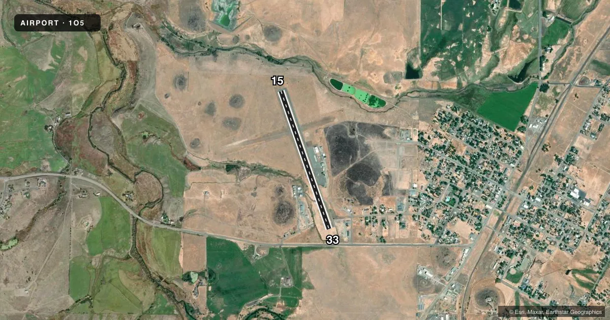
Airport sketch
Runways drawn to scale from FAA survey coordinates, rendered over satellite imagery. Not for navigation.
Approaches & charts
Services on the field
Fuel grades, oxygen, maintenance, ramp storage and lighting — as declared to the FAA by the airport operator.
Fuel & services
- Fuel
- 100LL
- Airframe repair
- Minor
- Power plant repair
- Minor
- Other services
- CARGO,GLD,INSTR,RNTL,TOW
Ramp & ground
- Transient storage
- Tie-down
- Landing fee
- No fee published
- Customs
- Not available
- Lighting schedule
- SEE RMK
- Wind indicator
- Lighted
- Segmented circle
- Yes
Fuel & FBOs
Cheapest 100LL and Jet A on the field and nearby. Always confirm with the FBO before taxi.
Airport notes
Surface conditions, obstructions, local procedures, lighting outages and other notes published with each FAA cycle.
General notes
- DEER ON & INVOF ARPT.
- BE ALERT TO MOUNTAIN NORTH AND HILLS EAST AND WEST OF AIRPORT.
- OCNL GLD AND BLN LAUNCHES.
- USE OF RY TRAFFIC PATTERNS STRONGLY RECOMMENDED. AVOID OVERFLIGHT OF TOWN EAST OF ARPT.
- APRT RESTRICTED TO ACFT WITH MAX CERT TKOF WEIGHT OF 12,500 LBS OR LESS; FOR MORE INFO CALL APT OPS (530) 459-5204.
- FOR CD CTC SEATTLE ARTCC AT 253-351-3694.
Lighting notes
- MIRL RY 15/33 PRESET LOW INTST; TO INCR INTST ACTVT - CTAF.
Approach & departure obstructions
- 05RY 05/23 EDGES MARKED WITH WHITE TIRES.
VFR map & nearby airports
VFR sectional. Tap any ICAO chip to open that airport.
Key facts · 1O5
Answer card- ICAO
- 1O5
- Name
- MONTAGUE-YREKA ROHRER FLD
- Location
- MONTAGUE, CALIFORNIA
- Elevation
- 2,527 ft MSL
- Traffic pattern altitude
- 3,327 ft MSL (800 AGL)
- Control tower
- Non-towered (use CTAF)
- Total runways
- 1
- Longest runway
- 15/33 · 3,360 ft
- Published ILS approaches
- 0
- Published frequencies
- 2
- Magnetic variation
- 15°
- Current flight rules
- VFR
- Current wind
- 000° at 0 kt
- Favored runway now
- –
Montague-Yreka Rohrer Fld sits in Montague, California at 2,527 ft MSL. It has one runway. Runway 15/33 is 3,360 ft of asphalt. The field is non-towered. CTAF and UNICOM are both 122.8. The pattern altitude is 800 ft AGL, which is 3,327 ft MSL.
No ILS approaches are published here. Steelman Aviation is on the field. It carries 100LL. For clearance delivery, contact Seattle ARTCC at 253-351-3694. The airport is restricted to aircraft with a maximum certified takeoff weight of 12,500 pounds or less. Call airport operations at (530) 459-5204 if that matters for your aircraft.
Use the pattern. That is strongly recommended here. Avoid overflying the town east of the airport. Watch for mountains north of the field. Hills sit east and west of the airport. Deer are reported on and near the airport. Occasional glider and balloon launches also happen here. Runway lights on 15/33 are preset to low intensity. Use the CTAF to raise them if needed at night.