METAR & TAF O46
O46 does not publish a METAR.
Showing the nearest reporting station: KSIY (SISKIYOU COUNTY) · 18.1 NM away. Conditions at O46 may differ.
METAR · KSIY
Observed 17:53Z
KSIY 261753Z AUTO 27005KT 10SM CLR 24/06 A3009 RMK AO2 SLP179 T02390061 10239 20100 58006
- Wind
- 270° @ 5 kt
- Visibility
- 10 SM
- Temp / Dew
- 24°C / 6°C
- Altimeter
- 30.09 inHg
- Clouds
- CLR
- Density alt
- 4,518 ft
- Ceiling
- Unlimited
- Rules
- VFR
Airport info & contacts
Manager on record, flight service, ARTCC, attendance schedule and pattern altitude — published by the FAA and refreshed every 28 days.
Location
- From city
- 4 NM NW
- VFR sectional
- KLAMATH FALLS
- ARTCC
- ZSE · SEATTLE
- NOTAM facility
- RIU (NOTAM-D)
Airport manager
- Name
- ADAM FILIPPONE
- Phone
- 530-842-8259
- Address
- 190 GREENHORN ROAD, YREKA CA 96097
Flight service · Hours
- FSS RIU
- RANCHO MURIETA1-800-WX-BRIEF
- Attendance
- MAY-OCT · MON-SUN · 0800-1700
- NOV-APR · MON-FRI · 0800-1700
Frequencies
Tap any row to copy the frequency to your clipboard.
Runways & pattern
Full pagePattern entry · RWY 32
LEFT TRAFFICRunway end performance
| End | TORA | TODA | ASDA | LDA | VGSI | Approach lights | Obstruction |
|---|---|---|---|---|---|---|---|
| 14 | — | — | — | — | VASI 2-box left(3°) | — | — |
| 32 | — | — | — | — | VASI 2-box left(3°) | — | 15', road, 900' from thr, 0' R of cntrln, slope 46 |
Declared distances in feet. TORA = takeoff run available, TODA = takeoff distance, ASDA = accelerate-stop, LDA = landing distance.
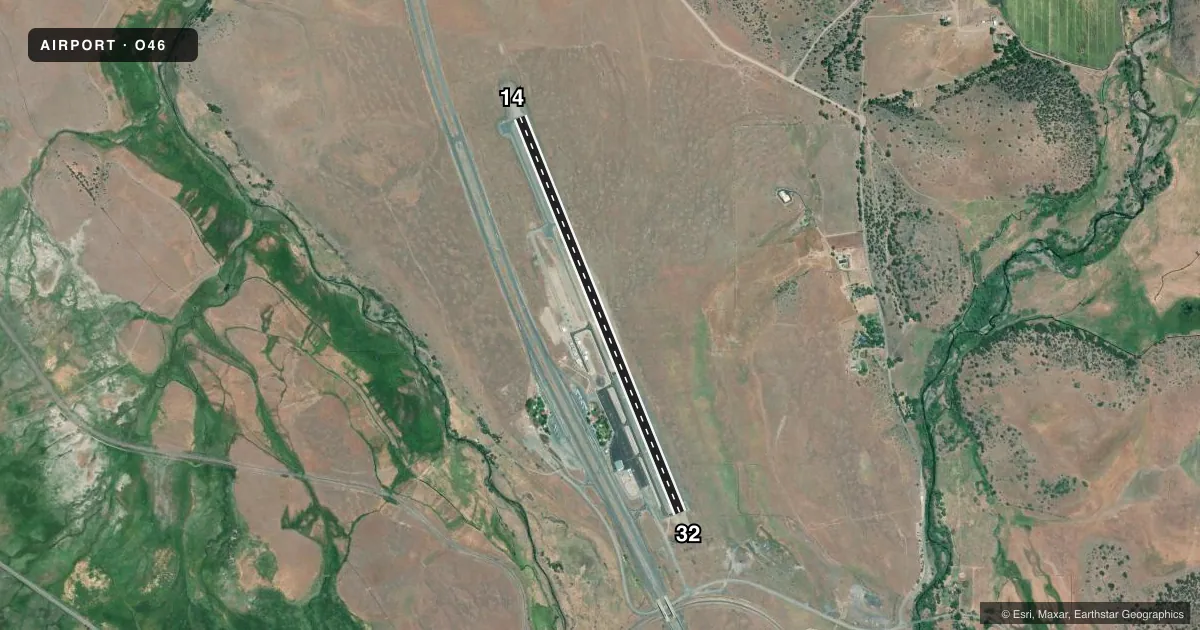
Airport sketch
Runways drawn to scale from FAA survey coordinates, rendered over satellite imagery. Not for navigation.
Approaches & charts
Services on the field
Fuel grades, oxygen, maintenance, ramp storage and lighting — as declared to the FAA by the airport operator.
Fuel & services
- Fuel
- 100LLA
- Oxygen (bottled)
- Not available
- Oxygen (bulk)
- Not available
- Airframe repair
- Not available
- Power plant repair
- Not available
Ramp & ground
- Transient storage
- Tie-down
- Landing fee
- Yes
- Customs
- Not available
- Lighting schedule
- SEE RMK
- Beacon schedule
- SS-SR
- Beacon
- White / Green (civil land)(WG)
- Wind indicator
- Lighted
- Segmented circle
- Yes
Fuel & FBOs
Cheapest 100LL and Jet A on the field and nearby. Always confirm with the FBO before taxi.
Airport notes
Surface conditions, obstructions, local procedures, lighting outages and other notes published with each FAA cycle.
General notes
- (E81) TAXIWAY LIGHTS AT ENTRANCES ONLY.
- RAMP TAXIWAYS CLSD NEAR MIDFIELD INTERSECTION AND NEAR SOUTH RAMP EXIT.
- FOR CD CTC SEATTLE ARTCC AT 253-351-3694.
Lighting notes
- ACTVT MIRL RY 14/32 - CTAF.
Other notes
- MANAGERDIRECTOR OF AIRPORTS OFFICE IN YREKA. ASTUMBAUGH@CO.SISKIYOU.CA.US.
- MANAGERPHONE RINGS AT COUNTY AIRPORT OFFICE - YREKA
VFR map & nearby airports
VFR sectional. Tap any ICAO chip to open that airport.
Key facts · O46
Answer card- ICAO
- O46
- Name
- WEED
- Location
- WEED, CALIFORNIA
- Elevation
- 2,942.7 ft MSL
- Traffic pattern altitude
- 3,942.7 ft MSL (1,000 AGL)
- Control tower
- Non-towered (use CTAF)
- Total runways
- 1
- Longest runway
- 14/32 · 5,000 ft
- Published ILS approaches
- 0
- Published frequencies
- 2
- Magnetic variation
- 14°
- Current flight rules
- VFR
- Current wind
- 270° at 5 kt
- Favored runway now
- RWY 32
WEED Airport sits in Weed, California at 2,942.7 ft MSL. It has one runway. Runway 14/32 is 5,000 ft long with an asphalt surface. The field is not towered. CTAF and UNICOM are both 122.7. No ILS approaches are published here.
Pattern altitude is not published. Use the standard 1,000 ft AGL pattern unless local guidance says otherwise. That puts the light piston pattern at about 3,943 ft MSL. Check the current Chart Supplement before you go. This field sits at higher elevation, so performance planning matters. Expect thinner air than you would see at lower airports.
Vali Aviation is on the field. It carries 100LL and Jet A. Call them at (530) 938-2656 for current services. Published remarks say taxiway lights are only at the entrances. They also note closed ramp taxiway sections near the midfield intersection and near the south ramp exit. Medium intensity runway lights on 14/32 are activated by CTAF. For clearance delivery, contact Seattle ARTCC at 253-351-3694. If you need airport office contact details, the county office is in Yreka.
For a first-time arrival, the main things are the elevation, the single runway and the published lighting notes. Plan the arrival with current chart data in hand.