METAR & TAF 24S
24S does not publish a METAR.
Showing the nearest reporting station: KSIY (SISKIYOU COUNTY) · 20.1 NM away. Conditions at 24S may differ.
METAR · KSIY
Observed 00:53Z
KSIY 260053Z AUTO 32012G20KT 10SM CLR 28/04 A2982 RMK AO2 SLP087 T02830039
- Wind
- 320° @ 12G20 kt
- Visibility
- 10 SM
- Temp / Dew
- 28°C / 4°C
- Altimeter
- 29.82 inHg
- Clouds
- CLR
- Density alt
- 6,201 ft
- Ceiling
- Unlimited
- Rules
- VFR
Airport info & contacts
Manager on record, flight service, ARTCC, attendance schedule and pattern altitude — published by the FAA and refreshed every 28 days.
Location
- From city
- 1 NM SW
- VFR sectional
- KLAMATH FALLS
- ARTCC
- ZSE · SEATTLE
- NOTAM facility
- MMV (NOTAM-D)
Airport manager
- Name
- STATE AIRPORT MGR
- Phone
- 503-378-4880
- Address
- 3040 25TH ST, SE, SALEM OR 97310
Flight service · Hours
- FSS MMV
- MC MINNVILLE1-800-WX-BRIEF
- Attendance
- Unattended
Frequencies
Tap any row to copy the frequency to your clipboard.
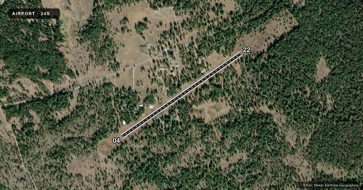
Runways & pattern
Full pagePattern entry · RWY 22
LEFT TRAFFICRunway end performance
| End | TORA | TODA | ASDA | LDA | VGSI | Approach lights | Obstruction |
|---|---|---|---|---|---|---|---|
| 04 | — | — | — | — | — | — | 17', trees, 252' from thr, 0' R of cntrln, slope 3 |
| 22 | — | — | — | — | — | — | 18', trees, 281' from thr, 0' R of cntrln, slope 4 |
Declared distances in feet. TORA = takeoff run available, TODA = takeoff distance, ASDA = accelerate-stop, LDA = landing distance.
Airport sketch
Runways drawn to scale from FAA survey coordinates, rendered over satellite imagery. Not for navigation.
Approaches & charts
Services on the field
Fuel grades, oxygen, maintenance, ramp storage and lighting — as declared to the FAA by the airport operator.
Fuel & services
- Fuel
- Not available
- Oxygen (bottled)
- Not available
- Oxygen (bulk)
- Not available
- Airframe repair
- Not available
- Power plant repair
- Not available
Ramp & ground
- Transient storage
- Tie-down
- Landing fee
- No fee published
- Wind indicator
- Yes
- Segmented circle
- Yes
Fuel & FBOs
Cheapest 100LL and Jet A on the field and nearby. Always confirm with the FBO before taxi.
Airport notes
Surface conditions, obstructions, local procedures, lighting outages and other notes published with each FAA cycle.
General notes
- RWY 22 SLOPES UP TO THE SW, WITH ABRUPT 4 0/0 RISE ON SW HALF OF RWY.
- RWY 04/22 12 FT TREES WI 25 FEET OF CNTRLN FULL LEN.
- OWNER ADVISES CTC OREGON DEPT OF AVIATION (503-378-4880) PRIOR TO USE.
- IRREGULAR WINTER MAINT. ARPT MAY BE CLSD BY SNOW.
- STRONG WINDS FROM ANY DIRECTION WILL LIKELY CAUSE LOW-LEVEL TURBULENCE.
- SURFACE CONDITIONS NOT REPORTED.
- FOR CD CTC SEATTLE ARTCC AT 253-351-3694.
Approach & departure obstructions
- 04+2-25 FT TREES 10-200 FT FM RWY END TO 125 FT BOTH SIDES OF CNTRLN.
- 22PILES OF ROCKS AND +10 FT TREES FM RY END TO 200 FT 65 FT R OF CNTRLN. 50' TREE AT 10' FROM RY END 100' L OF CL 15' TREES AT 100' FROM RY END 75' L OF CL
Other notes
- ESTABD PRIOR TO MAY 1959.
- TIRES PAINTED WHITE.
VFR map & nearby airports
VFR sectional. Tap any ICAO chip to open that airport.
Key facts · 24S
Answer card- ICAO
- 24S
- Name
- PINEHURST STATE
- Location
- PINEHURST, OREGON
- Elevation
- 3,643 ft MSL
- Traffic pattern altitude
- 4,643 ft MSL (1,000 AGL)
- Control tower
- Non-towered (use CTAF)
- Total runways
- 1
- Longest runway
- 04/22 · 2,800 ft
- Published ILS approaches
- 0
- Published frequencies
- 1
- Magnetic variation
- 18°
- Current flight rules
- VFR
- Current wind
- 320° at 12 kt
- Favored runway now
- RWY 22
Pinehurst State (24S) sits in Pinehurst, Oregon. The field elevation is 3,643 ft MSL. It has one runway, 04/22, which is 2,800 ft long. There is no control tower. CTAF is 122.9. No ILS approaches are published here.
Pattern altitude is not published. Use standard 1,000 ft AGL for light piston traffic unless the current Chart Supplement says otherwise. At this elevation, performance planning matters. Expect density altitude to be a real factor on warm days. The published remarks also call out strong winds from any direction as a source of low-level turbulence. Runway 22 slopes up to the southwest with an abrupt 4 percent rise on the southwest half of the runway. That is worth respecting on both landing and departure.
There are no on-field FBOs listed. Contact the airport operator or the FBO directly by phone before arrival if you need current services. The published remarks also note irregular winter maintenance. The airport may be closed by snow. There are trees and rocks near the runway ends, plus trees close to the centerline along the runway length. This is a strip where a first-time pilot should brief the runway environment carefully before going in.