METAR & TAF 2S7
2S7 does not publish a METAR.
Showing the nearest reporting station: KLMT (CRATER LAKE/KLAMATH RGNL) · 26.2 NM away. Conditions at 2S7 may differ.
METAR · KLMT
Observed 12:53Z
KLMT 271253Z AUTO 00000KT 10SM CLR 08/05 A3013 RMK AO2 SLP168 T00780050
- Wind
- 000° @ 0 kt
- Visibility
- 10 SM
- Temp / Dew
- 8°C / 5°C
- Altimeter
- 30.13 inHg
- Clouds
- CLR
- Density alt
- 4,134 ft
- Ceiling
- Unlimited
- Rules
- VFR
Airport info & contacts
Manager on record, flight service, ARTCC, attendance schedule and pattern altitude — published by the FAA and refreshed every 28 days.
Location
- From city
- 1 NM W
- VFR sectional
- KLAMATH FALLS
- ARTCC
- ZSE · SEATTLE
- NOTAM facility
- MMV (NOTAM-D)
Airport manager
- Name
- STATE AIRPORTS MGR
- Phone
- 503-378-4880
- Address
- 3040 25TH ST, SE, SALEM OR 97302-1125
Flight service · Hours
- FSS MMV
- MC MINNVILLE1-800-WX-BRIEF
- Attendance
- Unattended
Frequencies
Tap any row to copy the frequency to your clipboard.
Runways & pattern
Full pagePattern entry · RWY 17
LEFT TRAFFICRunway end performance
| End | TORA | TODA | ASDA | LDA | VGSI | Approach lights | Obstruction |
|---|---|---|---|---|---|---|---|
| 17 | — | — | — | — | — | — | 113', tree, 1216' from thr, 192' R of cntrln, slope 8 |
| 35 | — | — | — | — | — | — | 55', tree, 1143' from thr, 65' R of cntrln, slope 17 |
Declared distances in feet. TORA = takeoff run available, TODA = takeoff distance, ASDA = accelerate-stop, LDA = landing distance.
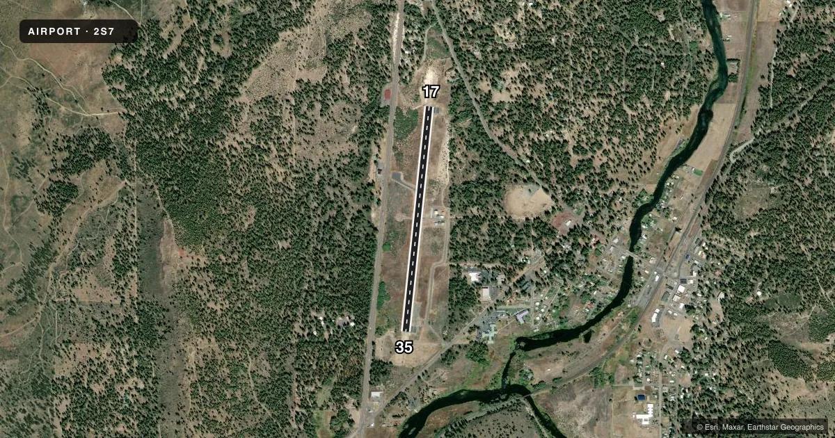
Airport sketch
Runways drawn to scale from FAA survey coordinates, rendered over satellite imagery. Not for navigation.
Approaches & charts
Services on the field
Fuel grades, oxygen, maintenance, ramp storage and lighting — as declared to the FAA by the airport operator.
Fuel & services
- Fuel
- Not available
- Oxygen (bottled)
- Not available
- Oxygen (bulk)
- Not available
- Airframe repair
- Not available
- Power plant repair
- Not available
Ramp & ground
- Transient storage
- Tie-down
- Landing fee
- No fee published
- Customs
- Not available
- Lighting schedule
- SEE RMK
- Beacon schedule
- SS-SR
- Beacon
- White / Green (civil land)(WG)
- Wind indicator
- Yes
- Segmented circle
- Yes
Fuel & FBOs
Cheapest 100LL and Jet A on the field and nearby. Always confirm with the FBO before taxi.
Airport notes
Surface conditions, obstructions, local procedures, lighting outages and other notes published with each FAA cycle.
General notes
- DOWNDRAFT AREA NORTH OF RY.
- IREG WINTER MAINTENANCE; ARPT CLSD WHEN COVERED IN SNOW.
- WEST SIDE TWY MARKED WITH REFLECTORS.
- SURFACE CONDITIONS NOT REPORTED.
- FOR CD CTC SEATTLE ARTCC AT 253-351-3694.
Lighting notes
- PILOT CONTROL LIGHTING (PCL) TO ACTVT MIRL RY 17/35 - CTAF.
Approach & departure obstructions
- 17RWY 17 APCH SLP 15:1 TO DTHR.
Other notes
- ESTABLISHED PRIOR TO 1959.
VFR map & nearby airports
VFR sectional. Tap any ICAO chip to open that airport.
Key facts · 2S7
Answer card- ICAO
- 2S7
- Name
- CHILOQUIN STATE
- Location
- CHILOQUIN, OREGON
- Elevation
- 4,221 ft MSL
- Traffic pattern altitude
- 5,221 ft MSL (1,000 AGL)
- Control tower
- Non-towered (use CTAF)
- Total runways
- 1
- Longest runway
- 17/35 · 3,749 ft
- Published ILS approaches
- 0
- Published frequencies
- 1
- Magnetic variation
- 18°
- Current flight rules
- VFR
- Current wind
- 000° at 0 kt
- Favored runway now
- –
Chiloquin State Airport sits in Chiloquin, Oregon. The field elevation is 4,221 ft MSL. It has one runway. Runway 17/35 is 3,749 ft long and paved with asphalt. There is no control tower. CTAF is 122.9.
No ILS approaches are published here. Pattern altitude is not published, so use the standard 1,000 ft AGL for light piston operations unless the current Chart Supplement says otherwise. That puts you at about 5,221 ft MSL on a standard pattern day. The airport is high enough that performance planning matters. Density altitude can get your attention fast in warm weather.
Published remarks say pilot-controlled lighting turns on medium-intensity runway lights for 17/35 through the CTAF. The west side taxiway is marked with reflectors. There is also a downdraft area north of the runway. Runway 17 has an approach slope limitation to the displaced threshold, so brief that side carefully before you come in. Winter can shut the field down when snow covers it. No on-field FBOs are listed, so contact the airport operator directly before arrival, or call the field on CTAF for current fuel and service availability.