METAR & TAF O86
Current METAR
Observed 05:55Z
KO86 270555Z AUTO 26006KT 10SM CLR 21/08 A3004 RMK A01
- Wind
- 260° @ 6 kt
- Visibility
- 10 SM
- Temp / Dew
- 21°C / 8°C
- Altimeter
- 30.04 inHg
- Clouds
- CLR
- Density alt
- 3,535 ft
- Ceiling
- Unlimited
- Rules
- VFR
Airport info & contacts
Manager on record, flight service, ARTCC, attendance schedule and pattern altitude — published by the FAA and refreshed every 28 days.
Location
- From city
- 0 NM E
- VFR sectional
- KLAMATH FALLS
- Pattern altitude
- 800 ft AGL · 3,190 ft MSL
- ARTCC
- ZOA · OAKLAND
- NOTAM facility
- RIU (NOTAM-D)
Airport manager
- Name
- PANOS KOKKAS
- Phone
- 530-623-1365
- Address
- PO BOX 2490, WEAVERVILLE CA 96093-2490
Flight service · Hours
- FSS RIU
- RANCHO MURIETA1-800-WX-BRIEF
- Attendance
- Unattended
Frequencies
Tap any row to copy the frequency to your clipboard.
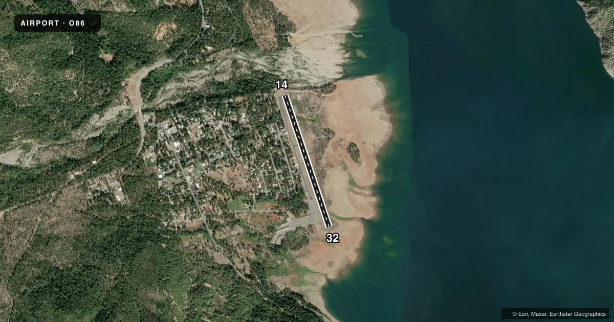
Runways & pattern
Full pagePattern entry · RWY 32
RIGHT TRAFFICAirport sketch
Runways drawn to scale from FAA survey coordinates, rendered over satellite imagery. Not for navigation.
Approaches & charts
Services on the field
Fuel grades, oxygen, maintenance, ramp storage and lighting — as declared to the FAA by the airport operator.
Fuel & services
- Fuel
- Not available
Ramp & ground
- Transient storage
- Tie-down
- Landing fee
- No fee published
- Customs
- Not available
- Wind indicator
- Yes
- Segmented circle
- Yes
Fuel & FBOs
Cheapest 100LL and Jet A on the field and nearby. Always confirm with the FBO before taxi.
Airport notes
Surface conditions, obstructions, local procedures, lighting outages and other notes published with each FAA cycle.
General notes
- HIGH TERRAIN ALL QUADRANTS.
- ARPT CLSD NIGHTS.
- TREES/HOMES WEST SIDE OF APRT.
- CALM WIND RY 14.
- NOISE ABATEMENT PROCEDURES IN EFFECT W & NW OF ARPT.
- INTERMITTENTLY CLOSED WINTERS DUE TO SNOW. CTC COUNTY TRANSPORTATION OFFICE FOR INFO 530-623-1365.
- BE ALERT TO DEER ON RY.
- GEESE ON AND IN THE VICINITY OF ARPT.
- FOR CD CTC OAKLAND ARTCC AT 510-745-3380.
Approach & departure obstructions
- 14DIRT ROAD AND 4 FT FENCE 120 FT FM APCH END RWY 14.
- 14RWY 14 APCH RATIO TO DISPLCD THLD 20:1
- 32RWY 32 APCH RATIO TO DISPLCD THLD 20:1
Other notes
- MANAGERDIRECTOR OF TRANSPORTATION
VFR map & nearby airports
VFR sectional. Tap any ICAO chip to open that airport.
Key facts · O86
Answer card- ICAO
- O86
- Name
- TRINITY CENTER
- Location
- TRINITY CENTER, CALIFORNIA
- Elevation
- 2,390 ft MSL
- Traffic pattern altitude
- 3,190 ft MSL (800 AGL)
- Control tower
- Non-towered (use CTAF)
- Total runways
- 1
- Longest runway
- 14/32 · 3,215 ft
- Published ILS approaches
- 0
- Published frequencies
- 1
- Magnetic variation
- 17°
- Current flight rules
- VFR
- Current wind
- 260° at 6 kt
- Favored runway now
- RWY 32
Trinity Center Airport sits in Trinity Center, California. The field elevation is 2,390 ft MSL. It has one runway, 14/32, which is 3,215 ft long and asphalt. There is no control tower. CTAF is 122.9. No ILS approaches are published here.
Pattern altitude is 800 ft AGL, which is 3,190 ft MSL. The airport sits in high terrain in all quadrants. That matters on departure and arrival, especially with local winds and summer density altitude. The published calm wind runway is 14. Trees and homes are on the west side of the airport. Noise abatement procedures are in effect west and northwest of the airport.
Plan for winter access issues. The field is intermittently closed in winter because of snow. The airport is also closed at night. There are no on-field FBOs listed, so verify services with the airport operator or the FBO directly before you go. Published remarks also note deer on the runway. Runway 14 has a dirt road and a 4 foot fence 120 feet from the approach end. Runway 32 has a displaced threshold with a 20 to 1 approach ratio. For clearance delivery, Oakland ARTCC is listed in the remarks.