METAR & TAF 62S
62S does not publish a METAR.
Showing the nearest reporting station: KBDN (BEND MUNI) · 56.5 NM away. Conditions at 62S may differ.
METAR · KBDN
Observed 13:35Z
KBDN 271335Z AUTO 00000KT 10SM CLR 13/08 A3011 RMK AO2
- Wind
- 000° @ 0 kt
- Visibility
- 10 SM
- Temp / Dew
- 13°C / 8°C
- Altimeter
- 30.11 inHg
- Clouds
- CLR
- Density alt
- 4,881 ft
- Ceiling
- Unlimited
- Rules
- VFR
Airport info & contacts
Manager on record, flight service, ARTCC, attendance schedule and pattern altitude — published by the FAA and refreshed every 28 days.
Location
- From city
- 1 NM SE
- VFR sectional
- KLAMATH FALLS
- ARTCC
- ZSE · SEATTLE
- NOTAM facility
- MMV (NOTAM-D)
Airport manager
- Name
- GLENNA WADE
- Phone
- 541-576-2216
- Address
- PO BOX 181, CHRISTMAS VALLEY OR 97638
Flight service · Hours
- FSS MMV
- MC MINNVILLE1-800-WX-BRIEF
- Attendance
- Unattended
Frequencies
Tap any row to copy the frequency to your clipboard.
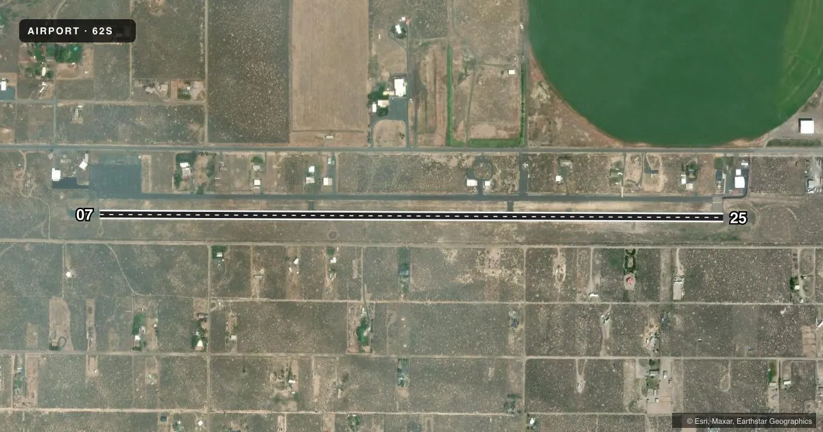
Runways & pattern
Full pagePattern entry · RWY 07
LEFT TRAFFICRunway end performance
| End | TORA | TODA | ASDA | LDA | VGSI | Approach lights | Obstruction |
|---|---|---|---|---|---|---|---|
| 07 | — | — | — | — | — | — | 40', tree, 998' from thr, 86' R of cntrln, slope 19 |
| 25 | — | — | — | — | PAPI 2-box left(3°) | — | — |
Declared distances in feet. TORA = takeoff run available, TODA = takeoff distance, ASDA = accelerate-stop, LDA = landing distance.
Airport sketch
Runways drawn to scale from FAA survey coordinates, rendered over satellite imagery. Not for navigation.
Approaches & charts
Services on the field
Fuel grades, oxygen, maintenance, ramp storage and lighting — as declared to the FAA by the airport operator.
Fuel & services
- Fuel
- Not available
- Oxygen (bottled)
- Not available
- Oxygen (bulk)
- Not available
Ramp & ground
- Transient storage
- Tie-down
- Landing fee
- No fee published
- Customs
- Not available
- Lighting schedule
- SEE RMK
- Beacon schedule
- SS-SR
- Beacon
- White / Green (civil land)(WG)
- Wind indicator
- Yes
- Segmented circle
- Yes
Fuel & FBOs
Cheapest 100LL and Jet A on the field and nearby. Always confirm with the FBO before taxi.
Airport notes
Surface conditions, obstructions, local procedures, lighting outages and other notes published with each FAA cycle.
General notes
- FOR CD CTC SEATTLE ARTCC AT 253-351-3694.
- REMOTE CTLD ACFT IN VCNTY.
Lighting notes
- ACTVT MIRL RY 07/25 & PAPI RY 25 - CTAF.
Other notes
- UNICOM MONITORED IRREGULARLY.
- OWNERCHRISTMAS VALLEY PARK & RECREATION DISTRICT.
VFR map & nearby airports
VFR sectional. Tap any ICAO chip to open that airport.
Key facts · 62S
Answer card- ICAO
- 62S
- Name
- CHRISTMAS VALLEY
- Location
- CHRISTMAS VALLEY, OREGON
- Elevation
- 4,320.1 ft MSL
- Traffic pattern altitude
- 5,320.1 ft MSL (1,000 AGL)
- Control tower
- Non-towered (use CTAF)
- Total runways
- 1
- Longest runway
- 07/25 · 5,200 ft
- Published ILS approaches
- 0
- Published frequencies
- 2
- Magnetic variation
- 14°
- Current flight rules
- VFR
- Current wind
- 000° at 0 kt
- Favored runway now
- –
Christmas Valley Airport sits in Christmas Valley, Oregon. The field elevation is 4,320.1 ft MSL. It has one runway. Runway 07/25 is 5,200 ft long and paved with asphalt. There is no control tower. CTAF and UNICOM are both 122.8, though UNICOM is monitored irregularly.
No ILS approaches are published here. The published remarks say medium intensity runway lights are available on 07/25. The PAPI is on runway 25. Remote controlled aircraft operate in the vicinity, so keep a sharp lookout on arrival and departure. The airport is owned by the Christmas Valley Park and Recreation District.
Pattern altitude is not published. Use the standard 1,000 ft AGL pattern unless local guidance says otherwise. That puts the light aircraft pattern at about 5,320.1 ft MSL. For clearance delivery, contact Seattle ARTCC at 253-351-3694. This is a high-elevation field, so expect thinner air and longer takeoff rolls than you would at a low airport. Verify current procedures in the FAA Chart Supplement before you go.