METAR & TAF O16
O16 does not publish a METAR.
Showing the nearest reporting station: KFOT (ROHNERVILLE) · 31.7 NM away. Conditions at O16 may differ.
METAR · KFOT
Observed 12:30Z
KFOT 271230Z AUTO 00000KT 10SM OVC011 13/13 A3008 RMK AO1
- Wind
- 000° @ 0 kt
- Visibility
- 10 SM
- Temp / Dew
- 13°C / 13°C
- Altimeter
- 30.08 inHg
- Clouds
- OVC
- Density alt
- 245 ft
- Ceiling
- 1,100 ft AGL
- Rules
- MVFR
Airport info & contacts
Manager on record, flight service, ARTCC, attendance schedule and pattern altitude — published by the FAA and refreshed every 28 days.
Location
- From city
- 2 NM SW
- VFR sectional
- KLAMATH FALLS
- ARTCC
- ZOA · OAKLAND
- NOTAM facility
- OAK (NOTAM-D)
Airport manager
- Name
- JUSTIN HOPMAN
- Phone
- 707-382-2551
- Address
- 3561 BOEING AVE., MCKINLEYVILLE CA 95519
Flight service · Hours
- FSS OAK
- OAKLAND1-800-WX-BRIEF
- Attendance
- Unattended
Frequencies
Tap any row to copy the frequency to your clipboard.
Runways & pattern
Full pagePattern entry · RWY 18
LEFT TRAFFICRunway end performance
| End | TORA | TODA | ASDA | LDA | VGSI | Approach lights | Obstruction |
|---|---|---|---|---|---|---|---|
| 18 | — | — | — | — | — | — | 354', hill, 4250' from thr, 0' R of cntrln, slope 11 |
| 36 | — | — | — | — | — | — | 25', trees, 200' from thr, 70' R of cntrln, slope 0 |
Declared distances in feet. TORA = takeoff run available, TODA = takeoff distance, ASDA = accelerate-stop, LDA = landing distance.
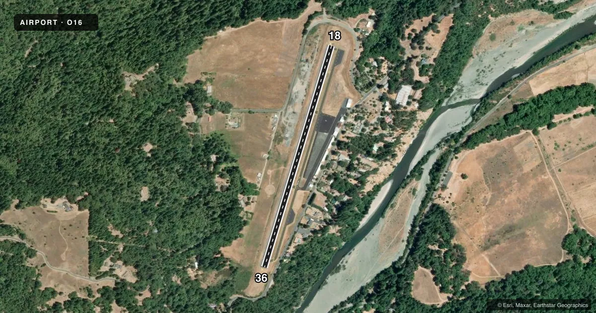
Airport sketch
Runways drawn to scale from FAA survey coordinates, rendered over satellite imagery. Not for navigation.
Approaches & charts
Services on the field
Fuel grades, oxygen, maintenance, ramp storage and lighting — as declared to the FAA by the airport operator.
Fuel & services
- Fuel
- 100LL
- Oxygen (bottled)
- Not available
- Oxygen (bulk)
- Not available
Ramp & ground
- Transient storage
- Tie-down
- Landing fee
- Yes
- Customs
- Not available
- Wind indicator
- Yes
- Segmented circle
- Yes
Fuel & FBOs
Cheapest 100LL and Jet A on the field and nearby. Always confirm with the FBO before taxi.
Airport notes
Surface conditions, obstructions, local procedures, lighting outages and other notes published with each FAA cycle.
General notes
- DAY USE ONLY; CLSD NGTS.
- TERRAIN SLOPES UP FROM THE END OF RY 36 APRXLY 12 FT BEFORE DROPPING OFF.
- FOR CD IF UNA TO CTC ON FSS FREQ, CTC OAKLAND ARTCC AT 510-745-3380.
- DEER IN VCNTY OF RWY.
Fuel notes
- 100LL100LL FUEL AVBL WITH CREDIT CARD - 24 HRS.
Approach & departure obstructions
- 18RY 18 +6 FT BRUSH @ 50 FT, 90 FT R.
- 36RWY 36 0-20 FT RISING TERRAIN 0-200 FT.
Other notes
- ESTABD PRIOR TO 15 MAY 1959.
- LNDG FEE: CTC ARPT OR CHECK ARPT WEBSITE FOR DTLS.
- MANAGERARPT MANAGER LOCATED AT CA REDWOOD COAST-HUMBOLDT COUNTY ARPT.
- MANAGERARPT MANAGER OFFICE LOCATED AT CA REDWOOD COAST-HUMBOLDT COUNTY ARPT.
VFR map & nearby airports
VFR sectional. Tap any ICAO chip to open that airport.
Key facts · O16
Answer card- ICAO
- O16
- Name
- GARBERVILLE
- Location
- GARBERVILLE, CALIFORNIA
- Elevation
- 550.9 ft MSL
- Traffic pattern altitude
- 1,550.9 ft MSL (1,000 AGL)
- Control tower
- Non-towered (use CTAF)
- Total runways
- 1
- Longest runway
- 18/36 · 2,783 ft
- Published ILS approaches
- 0
- Published frequencies
- 1
- Magnetic variation
- 17°
- Current flight rules
- MVFR
- Current wind
- 000° at 0 kt
- Favored runway now
- –
Garberville Airport (O16) sits in Garberville, California at 550.9 ft MSL. It has one runway. Runway 18/36 is 2,783 ft long and paved with asphalt. There is no control tower. CTAF is 122.9. No ILS approaches are published, so plan for non-precision or visual work only. Confirm current procedures before departure.
The published pattern altitude is not listed. Use the standard 1,000 ft AGL pattern for light piston operations unless the current Chart Supplement says otherwise. The field is day use only. It is closed at night. Deer are reported in the vicinity of the runway, so keep a sharp lookout on taxi, takeoff and landing. Runway 18 has brush close to the departure end area. Runway 36 has rising terrain near the runway end. The ground drops away beyond that. That makes a careful stabilized approach important, especially in a light airplane.
Garberville Airport has one on-field FBO listed as Garberville Airport. It carries 100LL. The remarks also note 24-hour self-serve fuel with credit card. The airport manager office is located at California Redwood Coast-Humboldt County Airport. If you need clearance delivery help, contact Oakland ARTCC at the number in the Chart Supplement if Flight Service cannot assist.