METAR & TAF KEKA
KEKA does not publish a METAR.
Showing the nearest reporting station: KACV (CALIFORNIA REDWOOD COAST-HUMBOLDT COUNTY) · 10.5 NM away. Conditions at KEKA may differ.
METAR · KACV
Observed 14:53Z
KACV 271453Z AUTO VRB03KT 10SM OVC013 14/12 A3009 RMK AO2 SLP195 T01390122 53004
- Wind
- VAR @ 3 kt
- Visibility
- 10 SM
- Temp / Dew
- 14°C / 12°C
- Altimeter
- 30.09 inHg
- Clouds
- OVC
- Density alt
- -317 ft
- Ceiling
- 1,300 ft AGL
- Rules
- MVFR
Airport info & contacts
Manager on record, flight service, ARTCC, attendance schedule and pattern altitude — published by the FAA and refreshed every 28 days.
Location
- From city
- 3 NM E
- VFR sectional
- KLAMATH FALLS
- Pattern altitude
- 800 ft AGL · 811 ft MSL
- ARTCC
- ZSE · SEATTLE
- NOTAM facility
- OAK (NOTAM-D)
Airport manager
- Name
- RYAN COOLEY
- Phone
- (707) 839-5402
- Address
- 3561 BOEING AVE., MCKINLEYVILLE CA 95519
Flight service · Hours
- FSS OAK
- OAKLAND1-800-WX-BRIEF
- Attendance
- Unattended
Frequencies
Tap any row to copy the frequency to your clipboard.
Runways & pattern
Full pagePattern entry · RWY 30
RIGHT TRAFFICRunway end performance
| End | TORA | TODA | ASDA | LDA | VGSI | Approach lights | Obstruction |
|---|---|---|---|---|---|---|---|
| 30 | — | — | — | — | VASI 2-box left(4°) | — | — |
Declared distances in feet. TORA = takeoff run available, TODA = takeoff distance, ASDA = accelerate-stop, LDA = landing distance.
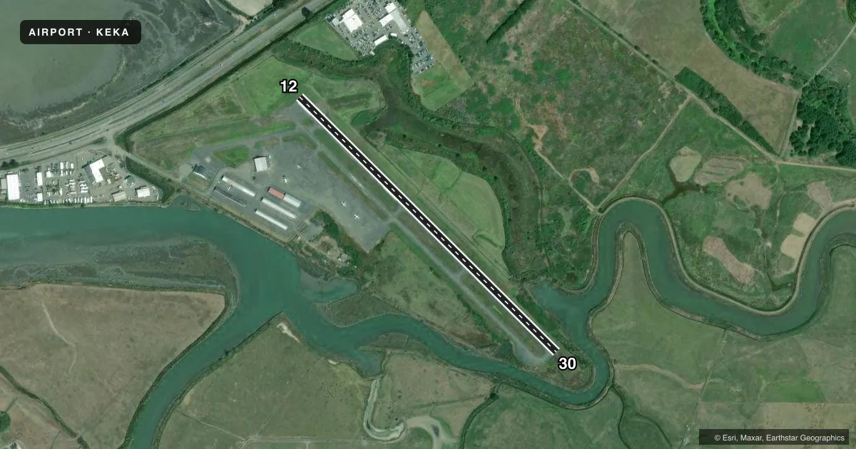
Airport sketch
Runways drawn to scale from FAA survey coordinates, rendered over satellite imagery. Not for navigation.
Approaches & charts
Services on the field
Fuel grades, oxygen, maintenance, ramp storage and lighting — as declared to the FAA by the airport operator.
Fuel & services
- Fuel
- 100LL
- Oxygen (bottled)
- Not available
- Oxygen (bulk)
- Not available
- Airframe repair
- Major
- Power plant repair
- Major
- Other services
- AFRT,CHTR,INSTR
Ramp & ground
- Transient storage
- Tie-down
- Landing fee
- Yes
- Customs
- Not available
- Lighting schedule
- SEE RMK
- Beacon schedule
- SS-SR
- Beacon
- White / Green (civil land)(WG)
- Wind indicator
- Lighted
- Segmented circle
- Yes
Fuel & FBOs
Cheapest 100LL and Jet A on the field and nearby. Always confirm with the FBO before taxi.
Airport notes
Surface conditions, obstructions, local procedures, lighting outages and other notes published with each FAA cycle.
General notes
- BE ALERT FOR BIRDS INVOF ARPT.
- BE AWARE; CTAF FREQ SHARED WITH NEARBY ARPT.
- FOR CD CTC SEATTLE ARTCC AT 253-351-3694.
- DEER IN VCNTY OF RWY.
Lighting notes
- ACTVT VASI RWY 30; MIRL RWY 12/30 - CTAF.
Approach & departure obstructions
- 30UNUSBL BYD 6.5 NM DUE TO TRRN.
Other notes
- PREDATES 1958 FA ACT.
- LNDG FEE: CTC ARPT OR CHECK ARPT WEBSITE FOR DTLS, EXEMPTIONS.
- MANAGERAIRPORT MANAGER LOCATED AT ARCATA/EUREKA AIRPORT.
VFR map & nearby airports
VFR sectional. Tap any ICAO chip to open that airport.
Key facts · KEKA
Answer card- ICAO
- KEKA
- Name
- MURRAY FLD
- Location
- EUREKA, CALIFORNIA
- Elevation
- 10.9 ft MSL
- Traffic pattern altitude
- 810.9 ft MSL (800 AGL)
- Control tower
- Non-towered (use CTAF)
- Total runways
- 1
- Longest runway
- 12/30 · 3,011 ft
- Published ILS approaches
- 0
- Published frequencies
- 2
- Magnetic variation
- 15°
- Current flight rules
- MVFR
- Current wind
- 000° at 3 kt
- Favored runway now
- RWY 30
MURRAY FLD sits in Eureka, California on the North Coast. Field elevation is 10.9 ft MSL. The airport has one runway, 12/30, which is 3,011 ft of asphalt. There is no control tower. Pattern altitude is 800 ft AGL, which is 810.9 ft MSL.
No ILS approaches are published here. CTAF and UNICOM are both 122.7. The CTAF is shared with a nearby airport. Listen carefully before keying up. County of Humboldt is on the field and carries 100LL. Call the airport at (707) 839-5401 for current fuel or airport details.
A few local items matter here. Birds are reported in the area. Deer are also present near the runway. Runway 30 has a visual approach slope indicator. Medium intensity runway lights are available on 12 and 30. They are controlled by CTAF. Runway end 30 is unusable beyond 6.5 NM because of terrain. For clearance delivery, contact Seattle ARTCC. First-time visitors should plan for a non-towered airport with shared radio traffic, coastal weather and terrain awareness on the 30 end.