METAR & TAF KFOT
Current METAR
Observed 15:10Z
KFOT 271510Z AUTO 27004KT 10SM SCT009 OVC013 14/14 A3009 RMK AO1
- Wind
- 270° @ 4 kt
- Visibility
- 10 SM
- Temp / Dew
- 14°C / 14°C
- Altimeter
- 30.09 inHg
- Clouds
- OVC
- Density alt
- 156 ft
- Ceiling
- 1,300 ft AGL
- Rules
- MVFR
Airport info & contacts
Manager on record, flight service, ARTCC, attendance schedule and pattern altitude — published by the FAA and refreshed every 28 days.
Location
- From city
- 3 NM SE
- VFR sectional
- KLAMATH FALLS
- Pattern altitude
- 800 ft AGL · 1,193 ft MSL
- ARTCC
- ZSE · SEATTLE
- NOTAM facility
- FOT (NOTAM-D)
Airport manager
- Name
- JUSTIN HOPMAN
- Phone
- 707-382-2551
- Address
- 3561 BOEING AVE., MCKINLEYVILLE CA 95519
Flight service · Hours
- FSS OAK
- OAKLAND1-800-WX-BRIEF
- Attendance
- Unattended
Frequencies
Tap any row to copy the frequency to your clipboard.
Runways & pattern
Full pagePattern entry · RWY 29
LEFT TRAFFICRunway end performance
| End | TORA | TODA | ASDA | LDA | VGSI | Approach lights | Obstruction |
|---|---|---|---|---|---|---|---|
| 11 | — | — | — | — | VASI 4-box right(3°) | — | — |
Declared distances in feet. TORA = takeoff run available, TODA = takeoff distance, ASDA = accelerate-stop, LDA = landing distance.
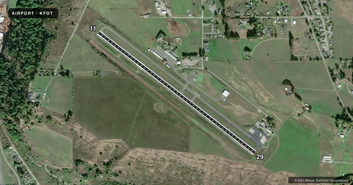
Airport sketch
Runways drawn to scale from FAA survey coordinates, rendered over satellite imagery. Not for navigation.
Approaches & charts
Services on the field
Fuel grades, oxygen, maintenance, ramp storage and lighting — as declared to the FAA by the airport operator.
Fuel & services
- Fuel
- 100LL
- Oxygen (bottled)
- Not available
- Oxygen (bulk)
- Not available
Ramp & ground
- Transient storage
- Tie-down
- Landing fee
- Yes
- Customs
- Not available
- Lighting schedule
- SEE RMK
- Beacon schedule
- SEE RMK
- Beacon
- White / Green (civil land)(WG)
- Wind indicator
- Lighted
- Segmented circle
- Yes
Fuel & FBOs
Cheapest 100LL and Jet A on the field and nearby. Always confirm with the FBO before taxi.
Airport notes
Surface conditions, obstructions, local procedures, lighting outages and other notes published with each FAA cycle.
General notes
- USFS AND CDF FIRE RETARDENT STATION.
- DEER INVOF OF RYS.
- FOR CD CTC SEATTLE ARTCC AT 253-351-3694.
Lighting notes
- DUSK-DAWN
- ACTVT REIL RWY 11 & 29; MIRL RWY 11/29 - CTAF.
Other notes
- ESTABD PRIOR TO 15 MAY 1959.
- LNDG FEE: CTC ARPT OR CHECK ARPT WEBSITE FOR DTLS, EXEMPTIONS.
- MANAGERARPT MANAGER LOCATED AT CA REDWOOD COAST-HUMBOLDT COUNTY ARPT.
VFR map & nearby airports
VFR sectional. Tap any ICAO chip to open that airport.
Key facts · KFOT
Answer card- ICAO
- KFOT
- Name
- ROHNERVILLE
- Location
- FORTUNA, CALIFORNIA
- Elevation
- 392.7 ft MSL
- Traffic pattern altitude
- 1,192.7 ft MSL (800 AGL)
- Control tower
- Non-towered (use CTAF)
- Total runways
- 1
- Longest runway
- 11/29 · 4,004 ft
- Published ILS approaches
- 0
- Published frequencies
- 1
- Magnetic variation
- 17°
- Current flight rules
- MVFR
- Current wind
- 270° at 4 kt
- Favored runway now
- RWY 29
Rohnerville Airport sits in Fortuna, California. Field elevation is 392.7 ft MSL. The airport has one runway. Runway 11/29 is 4,004 ft long with asphalt pavement. The field is not towered. CTAF is 122.9. Pattern altitude is 800 ft AGL, which puts it at 1,192.7 ft MSL.
No ILS approaches are published here. Plan with the current chart and expect a non-towered arrival. The published remarks matter here. Runway end identifier lights are on runways 11 and 29. Medium intensity runway lights are controlled from CTAF. The beacon runs from dusk to dawn. Deer are reported in the runway area. Keep a sharp scan on taxi, takeoff and landing.
Humboldt County is on the field. It carries AVGAS 100LL. Call (707) 839-5401 for current service details. This airport is also used as a United States Forest Service and California Department of Forestry fire retardant station. A landing fee is charged. The airport manager is located at California Redwood Coast-Humboldt County Airport. For clearance delivery, contact Seattle ARTCC at 253-351-3694. The field sits in coastal Northern California, so expect local weather and terrain to matter on any approach or departure. Check the current FAA Chart Supplement for any noise or operating notes before you go.