METAR & TAF 1Q4
1Q4 does not publish a METAR.
Showing the nearest reporting station: KTCY (TRACY MUNI) · 6.7 NM away. Conditions at 1Q4 may differ.
METAR · KTCY
Observed 03:35Z
KTCY 270335Z AUTO VRB04KT 10SM CLR 27/04 A2993 RMK A01
- Wind
- VAR @ 4 kt
- Visibility
- 10 SM
- Temp / Dew
- 27°C / 4°C
- Altimeter
- 29.93 inHg
- Clouds
- CLR
- Density alt
- 1,504 ft
- Ceiling
- Unlimited
- Rules
- VFR
Airport info & contacts
Manager on record, flight service, ARTCC, attendance schedule and pattern altitude — published by the FAA and refreshed every 28 days.
Location
- From city
- 7 NM SE
- VFR sectional
- SAN FRANCISCO
- Pattern altitude
- 800 ft AGL · 862 ft MSL
- ARTCC
- ZOA · OAKLAND
- NOTAM facility
- RIU (NOTAM-D)
Airport manager
- Name
- PAULA JESSUP
- Phone
- (209) 831-6215
- Address
- 5749 SOUTH TRACY BLVD, TRACY CA 95376-4168
Flight service · Hours
- FSS RIU
- RANCHO MURIETA1-800-WX-BRIEF
- Attendance
- Unattended
Frequencies
Tap any row to copy the frequency to your clipboard.
Runways & pattern
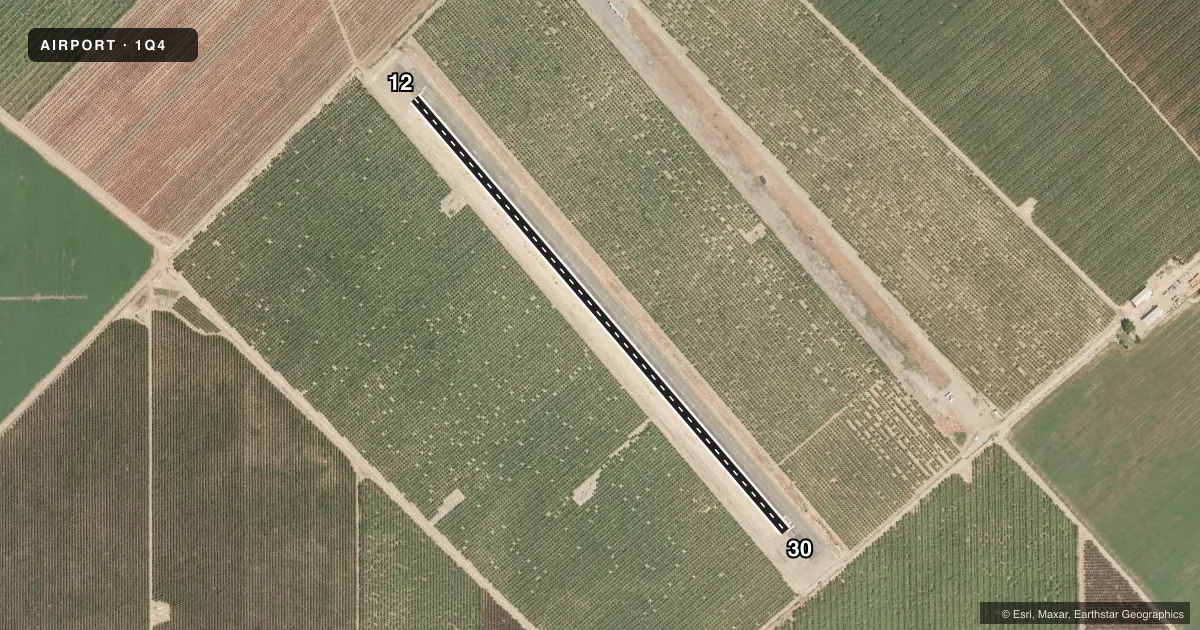
Full pagePattern entry · RWY 30
LEFT TRAFFICRunway end performance
| End | TORA | TODA | ASDA | LDA | VGSI | Approach lights | Obstruction |
|---|---|---|---|---|---|---|---|
| 12 | — | — | — | — | — | — | 15', trees, 340' from thr, 0' R of cntrln, slope 9 |
| 30 | — | — | — | — | — | — | 15', trees, 400' from thr, 0' R of cntrln, slope 13 |
Declared distances in feet. TORA = takeoff run available, TODA = takeoff distance, ASDA = accelerate-stop, LDA = landing distance.
Airport sketch
Runways drawn to scale from FAA survey coordinates, rendered over satellite imagery. Not for navigation.
Approaches & charts
Services on the field
Fuel grades, oxygen, maintenance, ramp storage and lighting — as declared to the FAA by the airport operator.
Fuel & services
- Fuel
- Not available
- Oxygen (bottled)
- Not available
- Oxygen (bulk)
- Not available
- Airframe repair
- Not available
- Power plant repair
- Not available
Ramp & ground
- Transient storage
- Not published
- Landing fee
- No fee published
- Customs
- Not available
- Wind indicator
- Yes
- Segmented circle
- No
Fuel & FBOs
Cheapest 100LL and Jet A on the field and nearby. Always confirm with the FBO before taxi.
Airport notes
Surface conditions, obstructions, local procedures, lighting outages and other notes published with each FAA cycle.
General notes
- MODEL AIRCRAFT ACTIVITY ON AND INVOF ABANDONED RY.
- AEROBATIC ACTIVITY NORTH NORTHEAST OF AIRPORT AND OVER ABANDONED PARALLEL RY 12/30 FM SURFACE TO 4,000 FEET MSL.
- NIGHT OPERATIONS PROHIBITED.
- PARL TWY FAILED COND WITH ROUGH/UNEVEN SFC FROM EXTSV ASPH RPR AND PATCHING.
- FOR CD CTC NORCAL APCH AT 916-361-0516.
- STANDING WATER ON PARL TWY AFTER RAIN.
- ERRONEOUS MRKGS ON RWY 12/30.
Runway surface & condition
- 12/30GROSS PAVEMENT STRENGTH PRVDD BY AIRPORT MANAGEMENT. 12500 LBS.
- 12/30PAVED RUNWAY SAFETY AREA RY 12/30.
Other notes
- ESTABD PRIOR TO 15 MAY 59.
- MANAGERCITY OF TRACY DEPT OF PARKS AND REC.
VFR map & nearby airports
VFR sectional. Tap any ICAO chip to open that airport.
Key facts · 1Q4
Answer card- ICAO
- 1Q4
- Name
- NEW JERUSALEM
- Location
- TRACY, CALIFORNIA
- Elevation
- 62 ft MSL
- Traffic pattern altitude
- 862 ft MSL (800 AGL)
- Control tower
- Non-towered (use CTAF)
- Total runways
- 1
- Longest runway
- 12/30 · 3,530 ft
- Published ILS approaches
- 0
- Published frequencies
- 1
- Magnetic variation
- 16°
- Current flight rules
- VFR
- Current wind
- 000° at 4 kt
- Favored runway now
- RWY 30
New Jerusalem Airport sits in Tracy, California. Field elevation is 62 ft MSL. The airport has one runway. Runway 12/30 is 3,530 ft long and paved with asphalt. There is no control tower. CTAF is 122.9. Pattern altitude is 800 ft AGL, which is 862 ft MSL.
No ILS approaches are published here. If you need current approach or airspace details, check the current FAA Chart Supplement before you go. The published remarks matter here. Night operations are prohibited. Aerobatic activity occurs north northeast of the airport and over the abandoned parallel runway 12/30 from the surface to 4,000 ft MSL. Model aircraft activity also occurs on and near the abandoned runway. The parallel taxiway is reported in failed condition with a rough and uneven surface after asphalt repair and patching. Standing water can also remain on the taxiway after rain. Runway 12/30 has erroneous markings. Verify the pavement layout carefully on arrival.
There are no on-field FBOs listed. Contact the airport operator directly before arrival if you need local support. The airport manager is the City of Tracy Department of Parks and Recreation. For clearance delivery, contact NorCal Approach at 916-361-0516. This is a low-elevation field. The operational picture is busy enough that a first-time pilot should brief the taxiway condition, the published pattern altitude and the nearby aerobatic and model aircraft activity before flying in.