METAR & TAF O22
Current METAR
Observed 13:15Z
KO22 271315Z AUTO 00000KT 10SM CLR 14/06 A3002 RMK A01
- Wind
- 000° @ 0 kt
- Visibility
- 10 SM
- Temp / Dew
- 14°C / 6°C
- Altimeter
- 30.02 inHg
- Clouds
- CLR
- Density alt
- 2,386 ft
- Ceiling
- Unlimited
- Rules
- VFR
Airport info & contacts
Manager on record, flight service, ARTCC, attendance schedule and pattern altitude — published by the FAA and refreshed every 28 days.
Location
- From city
- 1 NM SW
- VFR sectional
- SAN FRANCISCO
- ARTCC
- ZOA · OAKLAND
- NOTAM facility
- RIU (NOTAM-D)
Airport manager
- Name
- TONYA SCHEFTNER
- Phone
- (209) 533-6684
- Address
- 10723 AIRPORT RD, COLUMBIA CA 95310
Flight service · Hours
- FSS RIU
- RANCHO MURIETA1-800-WX-BRIEF
- Attendance
- 0800-1700
Frequencies
Tap any row to copy the frequency to your clipboard.
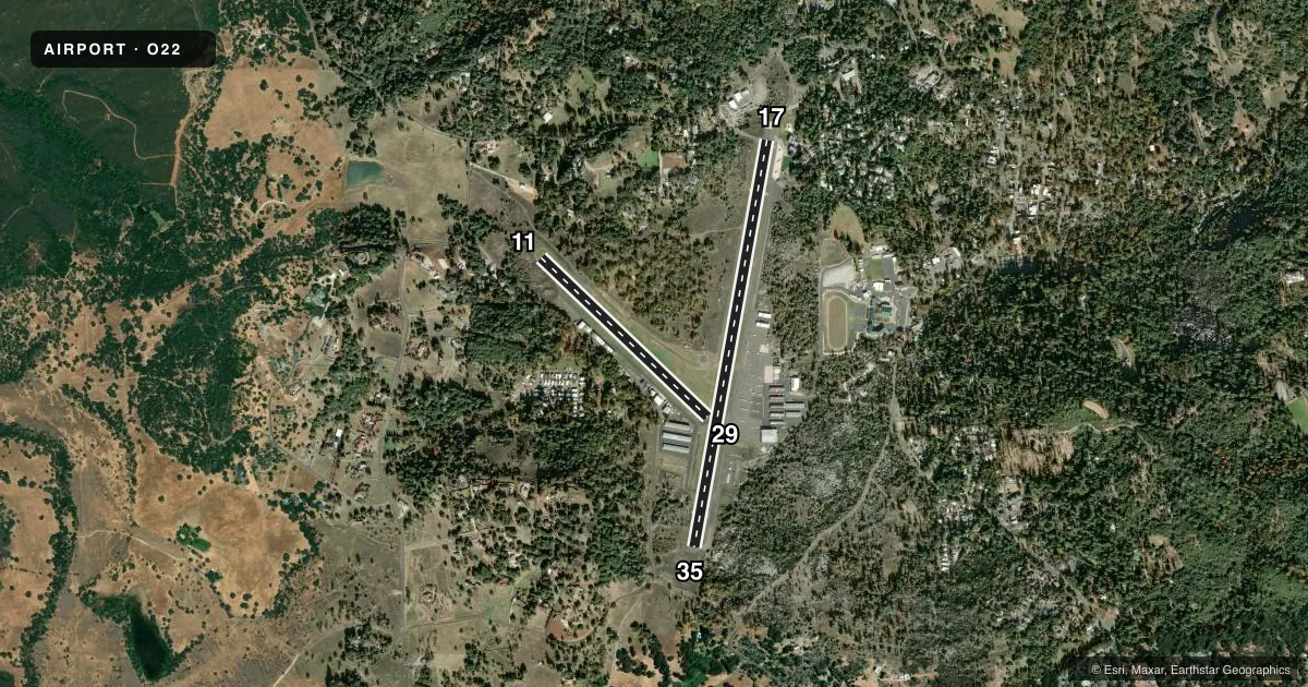
Runways & pattern
Full pagePattern entry · RWY 17
RIGHT TRAFFIC| Runway | Heading (°M) | Length | Surface | Traffic |
|---|---|---|---|---|
| 17/35 | 174° / 354° | 4,673 ft | ASPH | 17 R |
| 11/29 | 118° / 298° | 2,607 ft | TURF | 11 R |
Runway end performance
| End | TORA | TODA | ASDA | LDA | VGSI | Approach lights | Obstruction |
|---|---|---|---|---|---|---|---|
| 17 | — | — | — | — | VASI 2-box left(4.55°) | — | 33', gnd, 450' from thr, 125' R of cntrln, slope 8 |
| 35 | — | — | — | — | VASI 2-box left(4°) | — | 61', trees, 1700' from thr, 350' R of cntrln, slope 24 |
| 11 | — | — | — | — | — | — | 135', trees, 2190' from thr, 125' R of cntrln, slope 16 |
| 29 | — | — | — | — | — | — | 115', trees, 1600' from thr, 100' R of cntrln, slope 13 |
Declared distances in feet. TORA = takeoff run available, TODA = takeoff distance, ASDA = accelerate-stop, LDA = landing distance.
Airport sketch
Runways drawn to scale from FAA survey coordinates, rendered over satellite imagery. Not for navigation.
Approaches & charts
Services on the field
Fuel grades, oxygen, maintenance, ramp storage and lighting — as declared to the FAA by the airport operator.
Fuel & services
- Fuel
- 100LLA
- Oxygen (bottled)
- Low pressure
- Oxygen (bulk)
- Low pressure
- Airframe repair
- Major
- Power plant repair
- Major
- Other services
- AFRT,CHTR,INSTR,RNTL,SALES
Ramp & ground
- Transient storage
- Tie-down
- Landing fee
- Yes
- Customs
- Not available
- Lighting schedule
- SEE RMK
- Beacon schedule
- SS-SR
- Beacon
- White / Green (civil land)(WG)
- Wind indicator
- Lighted
- Segmented circle
- Yes
Fuel & FBOs
Cheapest 100LL and Jet A on the field and nearby. Always confirm with the FBO before taxi.
Airport notes
Surface conditions, obstructions, local procedures, lighting outages and other notes published with each FAA cycle.
General notes
- CALFIRE AIR TANKER OPRS FM ARPT DRG FIRE SEASON.
- VARYING WIND DIRECTION & VELOCITY MAY BE ENCOUNTERED AT MID POINT OF RY 17/35 DUE TO TERRAIN FEATURES & WIND FLOW PATTERNS.
- RY 11 DEPS PROHIBITED DUE TO CONFLICT WITH MAIN RY.
- TURF TWY NORTH SIDE OF RY 11/29 NOT RECOMMENDED FOR USE NOV - MAR
- RY 29 NOT RECOMMENDED FOR USE DURING WINTER MONTHS NOV THROUGH MAR.
- ALL JET ACFT ARE REQUESTED TO LAND RY 35 & DEPART RY 17 WIND & WEATHER PERMITTING.
- LANDING FEE FOR ALL COMMERCIAL OPERATORS REGARDLESS OF SIZE & CORPORATE ACFT OVER 12500 LBS GROSS LANDING WEIGHT.
- HEL PRKNG AREA 300 FT BY 120 FT (4 POSITIONS).
- AVOID FLIGHTS OVER COLUMBIA STATE PARK NE OF ARPT, AND HWY 49 BRIDGE 5 NM SW OF ARPT & VICINITY.
- FOR CD CTC NORCAL APCH AT 916-361-0516.
Lighting notes
- ARPT HAS TWO ROTG BCNS; ONE ON THE ARPT AND ONE 6500' SE THR RWY 35.
- ACTVT MIRL RY 17/35 & REIL RYS 17 & 35 - CTAF. VASI RY 17 & RY 35 OPER CONTINUOUSLY.
Runway surface & condition
- 17/35RY END SAFETY AREAS NSTD LENGTH; RY 17 210 FT; RY 35 300 FT.
Approach & departure obstructions
- 35RY 35 VASI UNUSABLE BYD 5 DEG LEFT AND RIGHT OF RY CNTRLN.
- 17APCH RATIO FM DSPLCD THLD 31:1.
- 35APCH RATIO FM DSPLCD THLD 37:1.
Other notes
- TPA RWY 11/29 800 FT AGL.
VFR map & nearby airports
VFR sectional. Tap any ICAO chip to open that airport.
Key facts · O22
Answer card- ICAO
- O22
- Name
- COLUMBIA
- Location
- COLUMBIA, CALIFORNIA
- Elevation
- 2,120.7 ft MSL
- Traffic pattern altitude
- 3,120.7 ft MSL (1,000 AGL)
- Control tower
- Non-towered (use CTAF)
- Total runways
- 2
- Longest runway
- 17/35 · 4,673 ft
- Published ILS approaches
- 0
- Published frequencies
- 4
- Magnetic variation
- 16°
- Current flight rules
- VFR
- Current wind
- 000° at 0 kt
- Favored runway now
- –
Columbia Airport (O22) sits in Columbia, California. The field elevation is 2,120.7 ft MSL. It has two runways. The longest is runway 17/35 at 4,673 ft. There is no control tower. NORCAL Approach handles the area on 125.1 and 363.2. No ILS approaches are published here.
Pattern altitude for runway 11/29 is 800 ft AGL. A standard 1,000 ft AGL pattern is used for light piston traffic where no other pattern altitude is published. Bald Eagle Aviation is on the field. It carries 100LL, Jet A and Jet A Prist. Call (209) 533-4616 for current service details.
This is a high-elevation airport with terrain in the area, so density altitude and wind deserve attention. The Chart Supplement notes variable wind at the midpoint of runway 17/35 due to terrain and wind flow patterns. It also asks pilots to avoid overflight of Columbia State Park northeast of the airport and Highway 49 Bridge 5 NM southwest of the field. CalFire air tanker activity can also affect traffic during fire season. Runway 11 departures are prohibited because of conflict with the main runway. Jet aircraft are requested to use runway 35 for landing and runway 17 for departure when conditions allow.