METAR & TAF E45
E45 does not publish a METAR.
Showing the nearest reporting station: KCPU (CALAVERAS COUNTY/MAURY RASMUSSEN FLD) · 28.0 NM away. Conditions at E45 may differ.
METAR · KCPU
Observed 10:55Z
KCPU 011055Z AUTO 00000KT 10SM CLR 15/07 A2982 RMK AO2 T01460073
- Wind
- 000° @ 0 kt
- Visibility
- 10 SM
- Temp / Dew
- 15°C / 7°C
- Altimeter
- 29.82 inHg
- Clouds
- CLR
- Density alt
- 3,760 ft
- Ceiling
- Unlimited
- Rules
- VFR
Airport info & contacts
Manager on record, flight service, ARTCC, attendance schedule and pattern altitude — published by the FAA and refreshed every 28 days.
Location
- From city
- 3 NM NE
- VFR sectional
- SAN FRANCISCO
- ARTCC
- ZOA · OAKLAND
- NOTAM facility
- RIU (NOTAM-D)
Airport manager
- Name
- TONYA SCHEFTNER
- Phone
- 209-533-5685
- Address
- 10723 AIRPORT RD, COLUMBIA CA 95310
Flight service · Hours
- FSS RIU
- RANCHO MURIETA1-800-WX-BRIEF
- Attendance
- Unattended
Frequencies
Tap any row to copy the frequency to your clipboard.
Runways & pattern
Full pagePattern entry · RWY 09
LEFT TRAFFICRunway end performance
| End | TORA | TODA | ASDA | LDA | VGSI | Approach lights | Obstruction |
|---|---|---|---|---|---|---|---|
| 09 | — | — | — | — | VASI 2-box left(4.5°) | — | 10', trees, 420' from thr, 25' R of cntrln, slope 22 |
| 27 | — | — | — | — | PAPI 2-box left(4°) | — | 35', trees, 980' from thr, slope 22 |
Declared distances in feet. TORA = takeoff run available, TODA = takeoff distance, ASDA = accelerate-stop, LDA = landing distance.
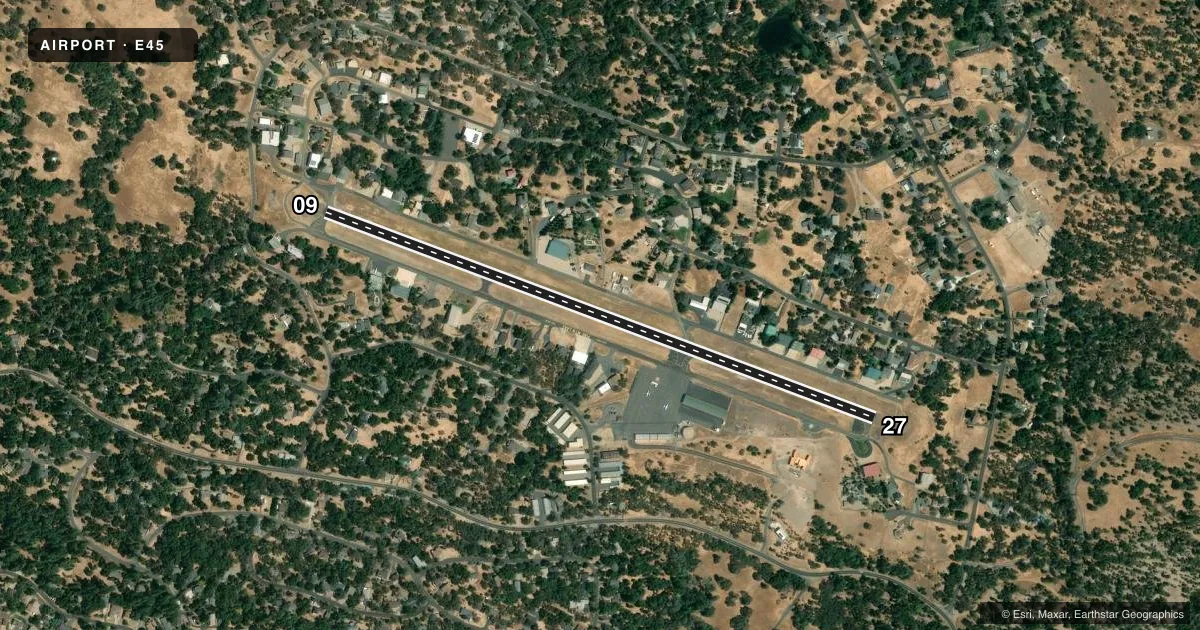
Airport sketch
Runways drawn to scale from FAA survey coordinates, rendered over satellite imagery. Not for navigation.
Approaches & charts
Services on the field
Fuel grades, oxygen, maintenance, ramp storage and lighting — as declared to the FAA by the airport operator.
Fuel & services
- Fuel
- 100LL
- Oxygen (bottled)
- Not available
- Oxygen (bulk)
- Not available
- Airframe repair
- Not available
- Power plant repair
- Not available
Ramp & ground
- Transient storage
- Tie-down
- Landing fee
- No fee published
- Lighting schedule
- SEE RMK
- Beacon schedule
- SS-SR
- Beacon
- White / Green (civil land)(WG)
- Wind indicator
- Lighted
- Segmented circle
- Yes
Fuel & FBOs
Cheapest 100LL and Jet A on the field and nearby. Always confirm with the FBO before taxi.
Airport notes
Surface conditions, obstructions, local procedures, lighting outages and other notes published with each FAA cycle.
General notes
- TRANSIENT PARKING AVBL.
- FEE FOR OVERNIGHT PARKING.
- (E81) RWY EXIT LGTS.
- DEER ON & INVOF ARPT AT ALL TIMES.
- FOR CD CTC OAKLAND ARTCC AT 510-745-3380.
- SAYWEATHER ADZY WX SYS AVBL. NOT AN FAA AWOS. CTAF ACTIVATION: 5 CLICKS FOR RWY LGTS, 4 CLICKS FOR FULL WX, 3 CLICKS FOR WINDS.
Lighting notes
- ACTVT MIRL RY 09/27 - CTAF.
Fuel notes
- 100LLFUEL 24 HR SELF-SERVICE.
Runway surface & condition
- 09/27200 FT GRVL RY SAFETY AREA WEST END; 100 FT GRVL RY SAFETY AREA EAST END.
Approach & departure obstructions
- 27PAPI RY 27 UNUSABLE BYD 7 DEG LEFT AND RIGHT OF CENTERLINE.
Other notes
- THIS AIRPORT HAS BEEN SURVEYED BY THE NATIONAL GEODETIC SURVEY.
- TREES IN APCHS ARE TO BE TOPPED OR REMOVED.
- MANAGEROFFICE AT COLUMBIA, CA ARPT.
VFR map & nearby airports
VFR sectional. Tap any ICAO chip to open that airport.
Key facts · E45
Answer card- ICAO
- E45
- Name
- GROVELAND/YOSEMITE
- Location
- GROVELAND, CALIFORNIA
- Elevation
- 2,932.6 ft MSL
- Traffic pattern altitude
- 3,932.6 ft MSL (1,000 AGL)
- Control tower
- Non-towered (use CTAF)
- Total runways
- 1
- Longest runway
- 09/27 · 3,624 ft
- Published ILS approaches
- 0
- Published frequencies
- 1
- Magnetic variation
- 15°
- Current flight rules
- VFR
- Current wind
- 000° at 0 kt
- Favored runway now
- –
Groveland/Yosemite Airport (E45) sits in Groveland, California at 2,932.6 ft MSL. It has one runway, 09/27, which is 3,624 ft long and asphalt. There is no control tower. CTAF is 122.9. No ILS approaches are published. The pattern altitude is not published, so use the standard 1,000 ft AGL for light piston traffic unless the current Chart Supplement says otherwise.
Mother Lode Aviation is on the field. It carries 100LL. Fuel is also available 24 hours by self-service. The airport remarks matter here. Deer are present on and near the airport at all times. Runway 27 has a PAPI, but it is unusable beyond 7 degrees left and right of centerline. Runway lights are medium intensity and are activated by CTAF. There are also gravel runway safety areas at both ends. Trees in the approaches are to be topped or removed.
For first-time arrivals, plan for mountain airport performance at this elevation. Check density altitude before departure. The airport is not towered, so expect self-announced traffic on CTAF. Overnight parking has a fee. For clearance delivery, contact Oakland ARTCC at 510-745-3380. The office is located at Columbia, California airport.