METAR & TAF KCPU
Current METAR
Observed 10:55Z
KCPU 011055Z AUTO 00000KT 10SM CLR 15/07 A2982 RMK AO2 T01460073
- Wind
- 000° @ 0 kt
- Visibility
- 10 SM
- Temp / Dew
- 15°C / 7°C
- Altimeter
- 29.82 inHg
- Clouds
- CLR
- Density alt
- 1,771 ft
- Ceiling
- Unlimited
- Rules
- VFR
Airport info & contacts
Manager on record, flight service, ARTCC, attendance schedule and pattern altitude — published by the FAA and refreshed every 28 days.
Location
- From city
- 4 NM SE
- VFR sectional
- SAN FRANCISCO
- ARTCC
- ZOA · OAKLAND
- NOTAM facility
- RIU (NOTAM-D)
Airport manager
- Name
- ALAINA BELLI
- Phone
- 209-736-2501
- Address
- 3600 CAROL KENNEDY DR., SAN ANDREAS CA 95249-0815
Flight service · Hours
- FSS RIU
- RANCHO MURIETA1-800-WX-BRIEF
- Attendance
- MON-FRI · 0830-1630
Frequencies
Tap any row to copy the frequency to your clipboard.
Runways & pattern
Full pagePattern entry · RWY 13
LEFT TRAFFICRunway end performance
| End | TORA | TODA | ASDA | LDA | VGSI | Approach lights | Obstruction |
|---|---|---|---|---|---|---|---|
| 31 | — | — | — | — | VASI 4-box right(3°) | — | — |
Declared distances in feet. TORA = takeoff run available, TODA = takeoff distance, ASDA = accelerate-stop, LDA = landing distance.
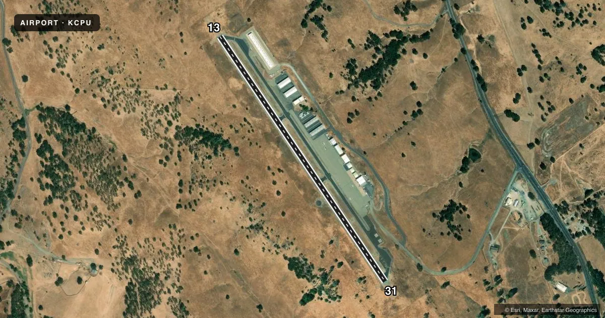
Airport sketch
Runways drawn to scale from FAA survey coordinates, rendered over satellite imagery. Not for navigation.
Approaches & charts
Services on the field
Fuel grades, oxygen, maintenance, ramp storage and lighting — as declared to the FAA by the airport operator.
Fuel & services
- Fuel
- 100LL
- Airframe repair
- Major
- Power plant repair
- Major
- Other services
- AVNCS,INSTR,RNTL
Ramp & ground
- Transient storage
- Tie-down
- Landing fee
- No fee published
- Lighting schedule
- SEE RMK
- Beacon schedule
- SS-SR
- Beacon
- White / Green (civil land)(WG)
- Wind indicator
- Lighted
- Segmented circle
- Yes
Fuel & FBOs
Cheapest 100LL and Jet A on the field and nearby. Always confirm with the FBO before taxi.
Airport notes
Surface conditions, obstructions, local procedures, lighting outages and other notes published with each FAA cycle.
General notes
- EFFECTIVE RY GRADIENT RY 13 0.6% UP.
- FOR CD CTC NORCAL APCH AT 916-361-0516.
Lighting notes
- ACTVT VASI RWY 31; MIRL RWY 13/31 - CTAF.
VFR map & nearby airports
VFR sectional. Tap any ICAO chip to open that airport.
Key facts · KCPU
Answer card- ICAO
- KCPU
- Name
- CALAVERAS COUNTY/MAURY RASMUSSEN FLD
- Location
- SAN ANDREAS, CALIFORNIA
- Elevation
- 1,327.9 ft MSL
- Traffic pattern altitude
- 2,327.9 ft MSL (1,000 AGL)
- Control tower
- Non-towered (use CTAF)
- Total runways
- 1
- Longest runway
- 13/31 · 3,602 ft
- Published ILS approaches
- 0
- Published frequencies
- 4
- Magnetic variation
- 15°
- Current flight rules
- VFR
- Current wind
- 000° at 0 kt
- Favored runway now
- –
Calaveras County/Maury Rasmussen Fld sits in San Andreas, California. The field elevation is 1,327.9 ft MSL. KCPU has one runway. Runway 13/31 is 3,602 ft long with asphalt pavement. There is no control tower. NORCAL Approach handles clearance delivery and approach support. The published frequencies are 125.1 and 363.2 MHz. No ILS approaches are published here.
Pattern altitude is not published. Use the standard 1,000 ft AGL for light piston traffic unless local procedures or ATC say otherwise. That puts the pattern at about 2,327.9 ft MSL. The runway has a 0.6 percent uphill gradient on runway 13. The published lighting notes matter here too. Visual approach slope guidance is available for runway 31. Medium intensity runway lights are activated for runways 13 and 31 on the CTAF.
Calaveras County Airport is the on-field FBO. It carries 100LL. If you are planning a stop here, call ahead at (209) 736-2501. For a first visit, pay attention to the elevation and the single-runway layout. The airport is non-towered. Use the current Chart Supplement for the latest remarks before you go.