METAR & TAF 3O1
3O1 does not publish a METAR.
Showing the nearest reporting station: KMER (CASTLE) · 20.2 NM away. Conditions at 3O1 may differ.
METAR · KMER
Observed 02:55Z
KMER 250255Z 33015KT 10SM CLR
- Wind
- 330° @ 15 kt
- Visibility
- 10 SM
- Temp / Dew
- —
- Altimeter
- —
- Clouds
- CLR
- Density alt
- —
- Ceiling
- Unlimited
- Rules
- VFR
Airport info & contacts
Manager on record, flight service, ARTCC, attendance schedule and pattern altitude — published by the FAA and refreshed every 28 days.
Location
- From city
- 2 NM E
- VFR sectional
- SAN FRANCISCO
- Pattern altitude
- 800 ft AGL · 879 ft MSL
- ARTCC
- ZOA · OAKLAND
- NOTAM facility
- RIU (NOTAM-D)
Airport manager
- Name
- JAMI WESTERVELT
- Phone
- 209-854-6471
- Address
- PO BOX 16, 352 FIFTH STREET, GUSTINE CA 95322-0016
Flight service · Hours
- FSS RIU
- RANCHO MURIETA1-800-WX-BRIEF
- Attendance
- Unattended
Frequencies
Tap any row to copy the frequency to your clipboard.
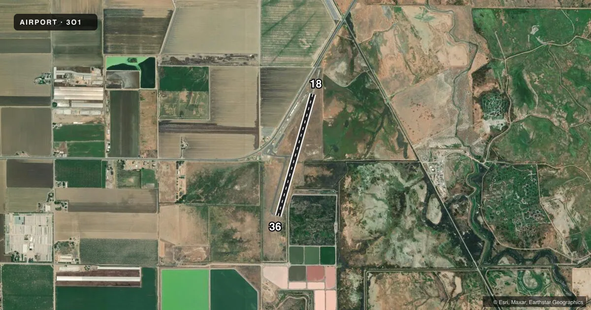
Runways & pattern
Full pagePattern entry · RWY 36
LEFT TRAFFICRunway end performance
| End | TORA | TODA | ASDA | LDA | VGSI | Approach lights | Obstruction |
|---|---|---|---|---|---|---|---|
| 18 | — | — | — | — | PAPI 2-box left(3°) | — | 15', road, 490' from thr, 155' R of cntrln, slope 19 |
| 36 | — | — | — | — | PAPI 2-box left(3°) | — | 35', pline, 1450' from thr, 530' R of cntrln, slope 36 |
Declared distances in feet. TORA = takeoff run available, TODA = takeoff distance, ASDA = accelerate-stop, LDA = landing distance.
Airport sketch
Runways drawn to scale from FAA survey coordinates, rendered over satellite imagery. Not for navigation.
Approaches & charts
Services on the field
Fuel grades, oxygen, maintenance, ramp storage and lighting — as declared to the FAA by the airport operator.
Fuel & services
- Fuel
- 100LL
- Other services
- AGRI
Ramp & ground
- Transient storage
- Tie-down
- Landing fee
- No fee published
- Customs
- Not available
- Lighting schedule
- SEE RMK
- Beacon schedule
- SS-SR
- Beacon
- White / Green (civil land)(WG)
- Wind indicator
- Lighted
- Segmented circle
- Yes
Fuel & FBOs
Cheapest 100LL and Jet A on the field and nearby. Always confirm with the FBO before taxi.
Airport notes
Surface conditions, obstructions, local procedures, lighting outages and other notes published with each FAA cycle.
General notes
- 675 X 50 PAVED RY SAFETY AREA AT NORTH END OF RY UNUSABLE FOR TKOF/LNDG.
- BIRD ACTIVITY INVOF ARPT.
- FOR CD CTC NORCAL APCH AT 916-361-0516.
- ARPT CLSD AT NGT.
- RWY 18/36 MARKINGS IN POOR COND; INDISTINGUISHABLE FROM TFC PAT ALT.
Lighting notes
- MIRL RWY 18/36 PRESET LOW INTST; TO INCREASE INTST ACTVT CTAF. ACTVT PAPI RWY 18 & PAPI RWY 36 CTAF 5 CLICKS. MIRL RWY 18/36 OTS INDEFLY. PAPI RWY 18 & PAPI RWY 36 OTS INDEFLY.
Fuel notes
- 100LLAUTOMATED CREDIT CARD FUEL SYS 24 HRS.
Other notes
- MANAGERCITY HALL
- 18/36RWY 18/36 POOR COND WITH WEEDS GROWING IN THE ALLIGATORING, AND LONGL AND LATERAL CRACKING.
VFR map & nearby airports
VFR sectional. Tap any ICAO chip to open that airport.
Key facts · 3O1
Answer card- ICAO
- 3O1
- Name
- GUSTINE
- Location
- GUSTINE, CALIFORNIA
- Elevation
- 79.2 ft MSL
- Traffic pattern altitude
- 879.2 ft MSL (800 AGL)
- Control tower
- Non-towered (use CTAF)
- Total runways
- 1
- Longest runway
- 18/36 · 3,207 ft
- Published ILS approaches
- 0
- Published frequencies
- 1
- Magnetic variation
- 16°
- Current flight rules
- VFR
- Current wind
- 330° at 15 kt
- Favored runway now
- RWY 36
Gustine Airport is in Gustine, California. The field elevation is 79.2 ft MSL. It has one runway, 18/36, which is 3,207 ft long and paved with asphalt. There is no control tower. CTAF is 122.9. No ILS approaches are published.
Pattern altitude is 800 ft AGL, which is 879.2 ft MSL. The runway headings are 196° and 16° magnetic. The airport is closed at night. Plan daylight operations only. Published remarks also say the north-end runway safety area is unusable for takeoff and landing. Runway 18/36 markings are in poor condition. The runway surface is also reported to be in poor condition with cracking and weeds in the pavement.
Gustine Airport has one on-field FBO listed as Gustine Airport. Fuel grades are not reported in the facts. The airport does have an automated credit card fuel system for 100LL. For current fuel details or ramp questions, call the FBO directly at (209) 854-6471. There is bird activity in the area. For clearance delivery, contact NorCal Approach at 916-361-0516. If you are planning a first visit, review the current Chart Supplement before you go so you are clear on the night closure, runway condition and any operational notes.