METAR & TAF 1C9
1C9 does not publish a METAR.
Showing the nearest reporting station: KCVH (HOLLISTER MUNI) · 4.4 NM away. Conditions at 1C9 may differ.
METAR · KCVH
Observed 15:15Z
KCVH 271515Z AUTO 00000KT 10SM CLR 15/12 A3006 RMK A01
- Wind
- 000° @ 0 kt
- Visibility
- 10 SM
- Temp / Dew
- 15°C / 12°C
- Altimeter
- 30.06 inHg
- Clouds
- CLR
- Density alt
- 15 ft
- Ceiling
- Unlimited
- Rules
- VFR
Airport info & contacts
Manager on record, flight service, ARTCC, attendance schedule and pattern altitude — published by the FAA and refreshed every 28 days.
Location
- From city
- 8 NM NW
- VFR sectional
- SAN FRANCISCO
- ARTCC
- ZOA · OAKLAND
- NOTAM facility
- OAK (NOTAM-D)
Airport manager
- Name
- MONTGOMERY GROVES
- Phone
- 408-242-2492
- Address
- 7901 FRAZIER LAKE ROAD, HOLLISTER CA 95023
Flight service · Hours
- FSS OAK
- OAKLAND1-800-WX-BRIEF
- Attendance
- Unattended
Frequencies
Tap any row to copy the frequency to your clipboard.
Runways & pattern
Full pagePattern entry · RWY 05W
LEFT TRAFFIC| Runway | Heading (°M) | Length | Surface | Traffic |
|---|---|---|---|---|
| 05W/23W | 50° / 230° | 3,000 ft | WATER | 23W R |
| 05/23 | 50° / 230° | 2,500 ft | TURF | 23 R |
Runway end performance
| End | TORA | TODA | ASDA | LDA | VGSI | Approach lights | Obstruction |
|---|---|---|---|---|---|---|---|
| 05W | — | — | — | — | — | — | 40', pline, 1100' from thr, 0' R of cntrln, slope 27 |
| 05 | — | — | — | — | — | — | 40', pline, 1350' from thr, 0' R of cntrln, slope 33 |
Declared distances in feet. TORA = takeoff run available, TODA = takeoff distance, ASDA = accelerate-stop, LDA = landing distance.
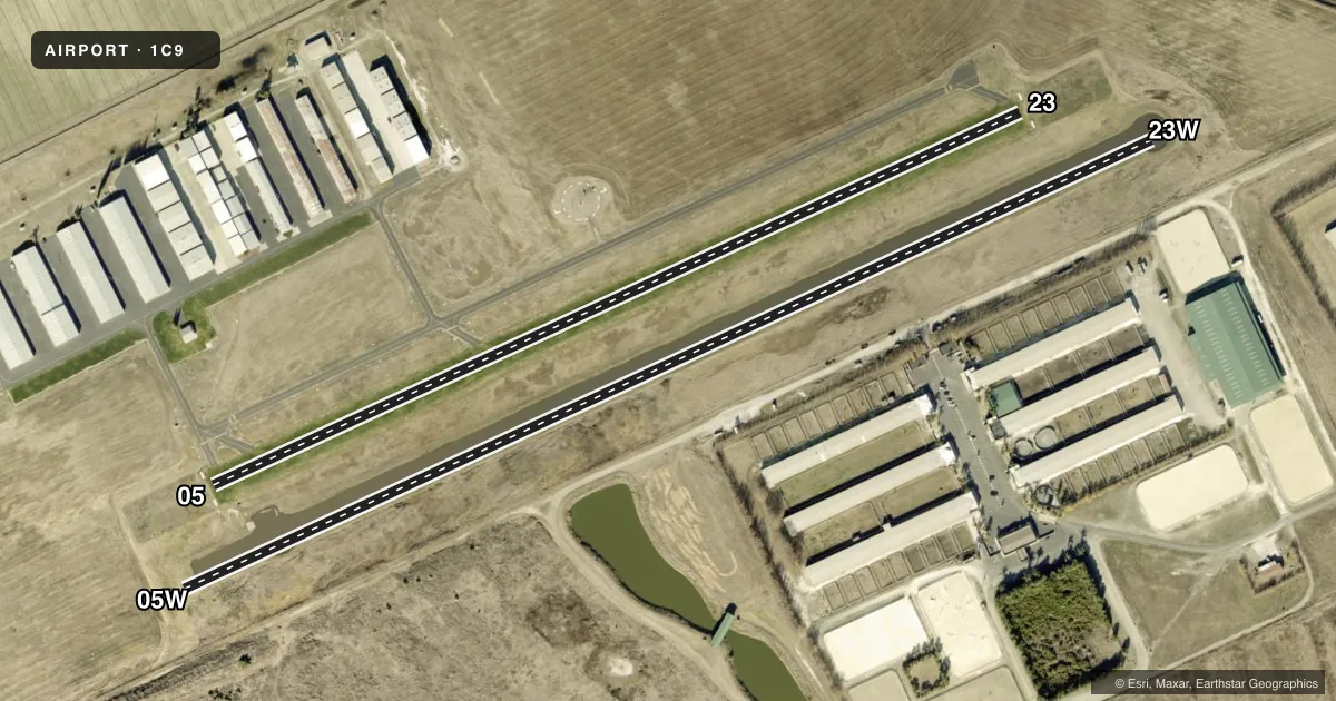
Airport sketch
Runways drawn to scale from FAA survey coordinates, rendered over satellite imagery. Not for navigation.
Approaches & charts
Services on the field
Fuel grades, oxygen, maintenance, ramp storage and lighting — as declared to the FAA by the airport operator.
Fuel & services
- Fuel
- Not available
Ramp & ground
- Transient storage
- Tie-down
- Landing fee
- No fee published
- Lighting schedule
- SEE RMK
- Wind indicator
- Lighted
- Segmented circle
- Yes
Fuel & FBOs
Cheapest 100LL and Jet A on the field and nearby. Always confirm with the FBO before taxi.
Airport notes
Surface conditions, obstructions, local procedures, lighting outages and other notes published with each FAA cycle.
General notes
- RAMP & DOCK FACS AVBL.
- BE ALERT TO SEAPLANE LNDG AREA (WTR CHNL) 200 FT SOUTH OF ADJ/PARL GRASS RWY.
- NO PRACTICE TKOFS & LNDGS RY 05/23 WHEN WET OR SOFT.
- NO MIDFIELD TKOFS OR BACK-TAXI ON RWY 5/23.
- BERM AND DITCH ADJ TO RWY 05 APCH END.
- PAEW VCNTY OF RWY 05/23 OCNLLY DURG DALGHT HRS.
- OCNL IRRIGATION ON TURF RWY AT NGT FROM MIDN TO 0600.
- RWY CLSD BY NOTAM FOR MOWING, TYPICALLY MON. CTN: EQUIP ON RWY DURG MOWING OPS.
- CTN: UTILITY WIRES ACROSS WEST END OF AFLD FOR APPROACH TO RWY 5 & WATERWAY 5W.
- NO TOUCH AND GO OPS.
- BIRDS FQTLY ON OF INVOF OF ARPT.
- FOR CD CTC NORCAL APCH AT 916-361-3748.
- RWY 05/23 IREG SFC
- WILDLIFE HAZ NR MOVMT AREA.
- USE AT YOUR OWN RISK.
Lighting notes
- ACTVT REIL RWY 23; LIRL RWY 05/23 - CTAF. REIL RWY 23 OPR CONSLY DUR DLGT HRS. DURING NGT HRS ACTVT REILRWY 23 - CTAF 7 CLICKS.
Runway surface & condition
- 05/23GROSS WGT LTD TO 6700 LBS.
Approach & departure obstructions
- 0505/23 BOUNDRY MARKERS EACH RY END.
Other notes
- CONDL: VFR USE ONLY.
- MANAGERPRESIDENT NOT LOCATED ON ARPT.
- 05W/23WTYPICAL WATER DEPTH 2.5 FT. WATER DEPTH NOTED AS SHALLOW AS 1.5 FT DEEP. NOT MKD.
VFR map & nearby airports
VFR sectional. Tap any ICAO chip to open that airport.
Key facts · 1C9
Answer card- ICAO
- 1C9
- Name
- FRAZIER LAKE AIRPARK
- Location
- HOLLISTER, CALIFORNIA
- Elevation
- 152 ft MSL
- Traffic pattern altitude
- 1,152 ft MSL (1,000 AGL)
- Control tower
- Non-towered (use CTAF)
- Total runways
- 2
- Longest runway
- 05W/23W · 3,000 ft
- Published ILS approaches
- 0
- Published frequencies
- 2
- Magnetic variation
- 15°
- Current flight rules
- VFR
- Current wind
- 000° at 0 kt
- Favored runway now
- –
Frazier Lake Airpark is in Hollister, California. Field elevation is 152 ft MSL. The airport has two runways. The longest is 3,000 ft on 05W/23W, which is a water runway. The other runway is 05/23 at 2,500 ft on turf. There is no control tower. CTAF and UNICOM are both 123.05.
No ILS approaches are published here. Pattern altitude is not published in the facts, so use the current FAA Chart Supplement before you fly. The published remarks matter here. Birds are frequently on or near the airport. Wildlife hazard is also noted near the movement area. There is a berm and ditch near the 05 approach end. Utility wires cross the west end of the field for approach to runway 5 and waterway 5W. The turf runway has occasional irrigation from midnight to 0600. Runway 05/23 is listed with an irregular surface. Gross weight is limited to 6,700 pounds on 05/23. No touch-and-go operations are allowed. Runway closures for mowing are typically on Monday. Equipment is sometimes on the runway during those periods. For clearance delivery, contact NorCal Approach at 916-361-3748. No on-field FBOs are listed.