METAR & TAF KOAR
Current METAR
Observed 16:35Z
KOAR 271635Z AUTO 24007KT 10SM OVC009 10/05 A3005 RMK AO2
- Wind
- 240° @ 7 kt
- Visibility
- 10 SM
- Temp / Dew
- 10°C / 5°C
- Altimeter
- 30.05 inHg
- Clouds
- OVC
- Density alt
- -592 ft
- Ceiling
- 900 ft AGL
- Rules
- IFR
Airport info & contacts
Manager on record, flight service, ARTCC, attendance schedule and pattern altitude — published by the FAA and refreshed every 28 days.
Location
- From city
- 2 NM NE
- VFR sectional
- SAN FRANCISCO
- ARTCC
- ZOA · OAKLAND
- NOTAM facility
- OAK (NOTAM-D)
Airport manager
- Name
- ADARIAN "AJ" LAWSON
- Phone
- 831-582-0102
- Address
- 781 NEESON ROAD, MARINA CA 93933
Flight service · Hours
- FSS OAK
- OAKLAND1-800-WX-BRIEF
- Attendance
- MON - FRI · 0800-1700
Frequencies
Tap any row to copy the frequency to your clipboard.
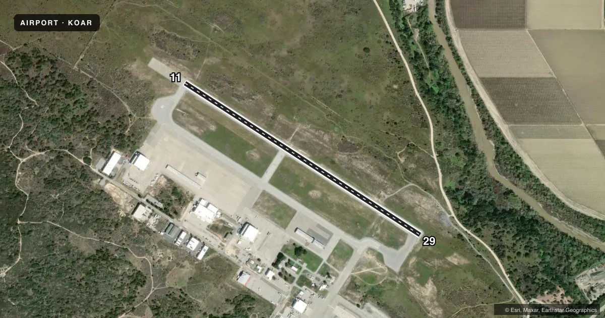
Runways & pattern
Full pagePattern entry · RWY 29
RIGHT TRAFFICRunway end performance
| End | TORA | TODA | ASDA | LDA | VGSI | Approach lights | Obstruction |
|---|---|---|---|---|---|---|---|
| 29 | — | — | — | — | PAPI 2-box left(3°) | — | — |
Declared distances in feet. TORA = takeoff run available, TODA = takeoff distance, ASDA = accelerate-stop, LDA = landing distance.
Airport sketch
Runways drawn to scale from FAA survey coordinates, rendered over satellite imagery. Not for navigation.
Approaches & charts
Services on the field
Fuel grades, oxygen, maintenance, ramp storage and lighting — as declared to the FAA by the airport operator.
Fuel & services
- Fuel
- 100LLA
- Oxygen (bottled)
- HIGH/LOW
- Airframe repair
- Major
- Power plant repair
- Major
- Other services
- AVNCS,PAJA
Ramp & ground
- Transient storage
- Tie-down
- Customs
- Not available
- Lighting schedule
- SEE RMK
- Beacon schedule
- SS-SR
- Beacon
- White / Green (civil land)(WG)
- Wind indicator
- Lighted
- Segmented circle
- Yes
Fuel & FBOs
Cheapest 100LL and Jet A on the field and nearby. Always confirm with the FBO before taxi.
Airport notes
Surface conditions, obstructions, local procedures, lighting outages and other notes published with each FAA cycle.
General notes
- DEP RY 29 EXECUTE 45 DEGREE RIGHT TURN TO AVOID OVERFLIGHT OF NOISE SENSITIVE RESIDENTIAL AREA.
- RY 29 CALM WIND RY.
- ULTRALIGHT & SKYDIVING ACTIVITY ON AND INVOF ARPT.
- SKYDIVING ACTIVITY ON SE SIDE OF AIRPORT
- FOR CD CTC NORCAL APCH AT 916-361-3748.
- 500 FT SWY DEP END RWY 29.
Lighting notes
- ACTVT MIRL RWY 11/29 - CTAF 7 CLICKS.
Fuel notes
- 100LLFUEL AVBL (100LL & JET A) 24 HRS VIA CREDIT CARD LOCK SYS.
Approach & departure obstructions
- 29PAPI OPERS CONTINUOUSLY.
Other notes
- THIS AIRPORT HAS BEEN SURVEYED BY THE NATIONAL GEODETIC SURVEY.
VFR map & nearby airports
VFR sectional. Tap any ICAO chip to open that airport.
Key facts · KOAR
Answer card- ICAO
- KOAR
- Name
- MARINA MUNI
- Location
- MARINA, CALIFORNIA
- Elevation
- 136.6 ft MSL
- Traffic pattern altitude
- 1,136.6 ft MSL (1,000 AGL)
- Control tower
- Non-towered (use CTAF)
- Total runways
- 1
- Longest runway
- 11/29 · 3,483 ft
- Published ILS approaches
- 0
- Published frequencies
- 6
- Magnetic variation
- 15°
- Current flight rules
- IFR
- Current wind
- 240° at 7 kt
- Favored runway now
- RWY 29
Marina Muni sits in Marina, California on the Monterey Bay side of the coast. Field elevation is 136.6 ft MSL. The airport has one runway. Runway 11/29 is 3,483 ft of asphalt, which is the longest runway on the field. There is no control tower. NorCal Approach handles clearance delivery and approach services. No ILS approaches are published here.
Pattern altitude is not published, so use the standard 1,000 ft AGL for light piston operations unless the current Chart Supplement says otherwise. The on-field FBO is Marina Municipal Airport. It carries 100LL and Jet A. Fuel is available 24 hours through a credit card lock system for both grades. Runway 29 has a continuously operating PAPI. Medium intensity runway lighting on 11/29 is activated with seven clicks on CTAF.
A first-time pilot should pay attention to the local traffic mix. Ultralight and skydiving activity occur on and near the airport. Skydiving activity is also noted on the southeast side. Runway 29 is the calm wind runway. Departing runway 29 calls for a 45-degree right turn to avoid noise-sensitive homes. There is also a 500-foot stopway beyond the departure end of runway 29. Check the current Chart Supplement and coordinate with NorCal or the FBO if you need the latest local procedures before arrival.