METAR & TAF E16
Current METAR
Observed 16:30Z
KE16 271630Z AUTO 34010KT 8SM CLR 19/12 A3006 RMK AO2
- Wind
- 340° @ 10 kt
- Visibility
- 8 SM
- Temp / Dew
- 19°C / 12°C
- Altimeter
- 30.06 inHg
- Clouds
- CLR
- Density alt
- 658 ft
- Ceiling
- Unlimited
- Rules
- VFR
Airport info & contacts
Manager on record, flight service, ARTCC, attendance schedule and pattern altitude — published by the FAA and refreshed every 28 days.
Location
- From city
- 1 NM E
- VFR sectional
- SAN FRANCISCO
- ARTCC
- ZOA · OAKLAND
- NOTAM facility
- E16 (NOTAM-D)
Airport manager
- Name
- SCOTT RIDDLE
- Phone
- 408-918-7700
- Address
- 2500 CUNNINGHAM, SAN JOSE CA 95046
Flight service · Hours
- FSS OAK
- OAKLAND1-800-WX-BRIEF
- Attendance
- WED-THU · 1000-1700
Frequencies
Tap any row to copy the frequency to your clipboard.
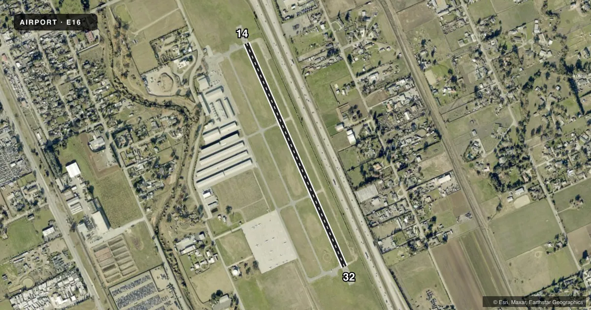
Runways & pattern
Full pagePattern entry · RWY 32
RIGHT TRAFFICRunway end performance
| End | TORA | TODA | ASDA | LDA | VGSI | Approach lights | Obstruction |
|---|---|---|---|---|---|---|---|
| 14 | — | — | — | — | PAPI 2-box left(4°) | — | 41', pole, 1100' from thr, 200' R of cntrln, slope 21 |
| 32 | — | — | — | — | PAPI 2-box left(4°) | — | 32', tree, 1040' from thr, 73' R of cntrln, slope 26 |
Declared distances in feet. TORA = takeoff run available, TODA = takeoff distance, ASDA = accelerate-stop, LDA = landing distance.
Airport sketch
Runways drawn to scale from FAA survey coordinates, rendered over satellite imagery. Not for navigation.
Approaches & charts
Services on the field
Fuel grades, oxygen, maintenance, ramp storage and lighting — as declared to the FAA by the airport operator.
Fuel & services
- Fuel
- AUL94
- Oxygen (bottled)
- HIGH/LOW
- Oxygen (bulk)
- Not available
- Airframe repair
- Major
- Power plant repair
- Major
- Other services
- CHTR,INSTR,PAJA,RNTL,SALES
Ramp & ground
- Transient storage
- Tie-down
- Hangar
- Landing fee
- No fee published
- Customs
- Not available
- Lighting schedule
- SEE RMK
- Beacon schedule
- SEE RMK
- Beacon
- White / Green (civil land)(WG)
- Wind indicator
- Lighted
- Segmented circle
- Yes
Fuel & FBOs
Cheapest 100LL and Jet A on the field and nearby. Always confirm with the FBO before taxi.
Airport notes
Surface conditions, obstructions, local procedures, lighting outages and other notes published with each FAA cycle.
General notes
- NO CROSSWIND TURNS BLO 1300 FT MSL; DEPS CLIMB TO 2000 FT MSL.
- APCHG ACFT FLY DOWNWIND LEGS E OF FREEWAY.
- FOR CD CTC NORCAL APCH AT 916-361-3748.
Lighting notes
- DUSK-DAWN.
- ACTVT MIRL RWY 14/32 - CTAF. PAPI RWYS 14 & 32 ON CONTINUOUSLY.
Fuel notes
- UL94BGNG JANUARY 1, 2022 100LL UNAVBL.
Other notes
- LFT TFC PATTERN RWY 14 TO AVOID FLYING OVER SCHOOL & RGT TFC PATTERN RWY 32 TO AVOID FLYING OVER SCHOOL.
- OWNERERIC PETERSON, DIRECTOR OF AIRPORTS.
VFR map & nearby airports
VFR sectional. Tap any ICAO chip to open that airport.
Key facts · E16
Answer card- ICAO
- E16
- Name
- SAN MARTIN
- Location
- SAN MARTIN, CALIFORNIA
- Elevation
- 283.8 ft MSL
- Traffic pattern altitude
- 1,283.8 ft MSL (1,000 AGL)
- Control tower
- Non-towered (use CTAF)
- Total runways
- 1
- Longest runway
- 14/32 · 3,095 ft
- Published ILS approaches
- 0
- Published frequencies
- 6
- Magnetic variation
- 15°
- Current flight rules
- VFR
- Current wind
- 340° at 10 kt
- Favored runway now
- RWY 32
San Martin Airport sits in San Martin, California. The field elevation is 283.8 ft MSL. It has one runway, 14/32, which is 3,095 ft long and asphalt. This is an uncontrolled airport with no tower. The beacon runs from dusk to dawn. No ILS approaches are published here.
Pattern altitude is not published. Use the standard 1,000 ft AGL for light piston operations unless the current Chart Supplement says otherwise. Published remarks call for left traffic on runway 14 and right traffic on runway 32 to keep aircraft away from the school. Arrivals also fly downwind legs east of the freeway. No crosswind turns are allowed below 1,300 ft MSL. Departures climb to 2,000 ft MSL.
San Martin Aviation is on the field. It carries JET_A and UL94. 100LL is unavailable here. Medium intensity runway lights for 14/32 are pilot-activated on CTAF. Precision approach path indicators operate continuously on both runway ends. For clearance delivery, contact NorCal Approach. The airport sits in a busy Northern California environment, so expect to stay sharp on traffic flow and comply with the published pattern and departure notes.