METAR & TAF KMRY
Current METAR
Observed 00:54Z
KMRY 270054Z 26012G19KT 10SM FEW016 19/13 A3005 RMK AO2 SLP185 T01890133
- Wind
- 260° @ 12G19 kt
- Visibility
- 10 SM
- Temp / Dew
- 19°C / 13°C
- Altimeter
- 30.05 inHg
- Clouds
- FEW
- Density alt
- 637 ft
- Ceiling
- Unlimited
- Rules
- VFR
Airport info & contacts
Manager on record, flight service, ARTCC, attendance schedule and pattern altitude — published by the FAA and refreshed every 28 days.
Location
- From city
- 3 NM SE
- VFR sectional
- SAN FRANCISCO
- Pattern altitude
- 1,500 ft AGL · 1,757 ft MSL
- ARTCC
- ZOA · OAKLAND
- NOTAM facility
- MRY (NOTAM-D)
Airport manager
- Name
- CHRIS MORELLO
- Phone
- 831-648-7000
- Address
- 200 FRED KANE DR., SUITE 200, MONTEREY CA 93940
Flight service · Hours
- FSS OAK
- OAKLAND1-800-WX-BRIEF
- Attendance
- ALL
Frequencies
Tap any row to copy the frequency to your clipboard.
Runways & pattern
Full pagePattern entry · RWY 28L
RIGHT TRAFFIC| Runway | Heading (°M) | Length | Surface | Traffic |
|---|---|---|---|---|
| 10R/28LFavored | 98° / 278° | 7,175 ft | ASPH | 28L R |
| 10L/28R | 98° / 278° | 3,503 ft | ASPH | 28R R |
Runway end performance
| End | TORA | TODA | ASDA | LDA | VGSI | Approach lights | Obstruction |
|---|---|---|---|---|---|---|---|
| 10R | 7,175' | 7,175' | 7,175' | 7,000' | PAPI 4-box left(3°) | MALSR | — |
| 28L | 7,175' | 7,175' | 7,175' | 7,000' | PAPI 4-box right(3.5°) | — | — |
| 10L | — | — | — | — | PAPI 2-box left(3°) | — | — |
| 28R | — | — | — | — | PAPI 2-box left(3.85°) | — | — |
Declared distances in feet. TORA = takeoff run available, TODA = takeoff distance, ASDA = accelerate-stop, LDA = landing distance.
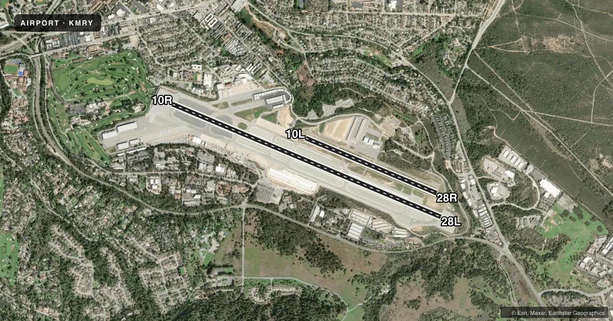
Airport sketch
Runways drawn to scale from FAA survey coordinates, rendered over satellite imagery. Not for navigation.
Approaches & charts
ILS · 2
Services on the field
Fuel grades, oxygen, maintenance, ramp storage and lighting — as declared to the FAA by the airport operator.
Fuel & services
- Fuel
- 100LLAUL94
- Oxygen (bottled)
- Low pressure
- Oxygen (bulk)
- Low pressure
- Airframe repair
- Major
- Power plant repair
- Major
- Other services
- AFRT,AVNCS,CHTR,INSTR,RNTL,SALES
Ramp & ground
- Transient storage
- Tie-down
- Landing fee
- No fee published
- Customs
- Not available
- Lighting schedule
- SEE RMK
- Beacon schedule
- SS-SR
- Beacon
- White / Green (civil land)(WG)
- Wind indicator
- Lighted
- Segmented circle
- Yes
Fuel & FBOs
Cheapest 100LL and Jet A on the field and nearby. Always confirm with the FBO before taxi.
Airport notes
Surface conditions, obstructions, local procedures, lighting outages and other notes published with each FAA cycle.
General notes
- ROTARY WING ACFT EXPECT TO FOLLOW FIXED WING PAT TO RWY LNDG.
- LTD TRANSIENT PARKING PPR REQUIRED FOR LARGE AND TURBINE POWERED MULT ENG ACFT; (831) 648-7000 OPTION 2.
- ON DEP NO TURNS BLO 900 FT UNLESS ATC DIRECTED.
- NOISE ABATEMENT PROCEDURES IN EFFECT 2300-0700.
- PLEASE AVOID FLTS OVR RESIDENTIAL AREAS, N AND S. CTC ARPT OPNS 831-648-7000 OPTION 2 OR WWW.MONTEREYAIRPORT.COM FOR PROCS.
- ACFT WITH WINGSPAN GREATER THAN 95 FT MAY NOT TAXI PAST THE TERMINAL ON TWY ALPHA WHEN AN MD-80 OR 757 IS PARKED AT TERMINAL.
- ATCT NON-VISIBILITY AREA TAXIWAY ALPHA EAST HOLDING BAY.
- ACFT WITH WINGSPAN GREATER THAN 65' PROHIBITED ON TWY BRAVO BETWEEN TWY ECHO AND TWY DELTA.
- FACILITY CONSTRAINTS FOR COMMERCIAL DIVERSIONS: ADG III AND LARGER WITH SEATING CAPACITY MORE THEN 150 PAX ARE HIGHLY DISCOURAGED. CBP PROCESSING FACILITIES UNAVAILABLE.
- FOR CD OR CNL IFR WHEN ATCT CLSD, CTC NORCAL APP CON ON 133.5; IF UNA, CTC NORCAL APCH AT 916-361-3748.
- FIRE STN APN CLSD TO HEL TFC.
- AVOID FLYING RWY 28L RNAV Y WHEN POSS TO RDC NOISE IMPACTS.
- RWY 28L RNAV AND RNP APCHS ARE NOT TO BE USED FOR PRACTICE APCHS.
Lighting notes
- WHEN ATCT CLSD, ACTVT MALSR RWY 10R, REIL RWY 28L, PAPI RWY 10L, 10R, 28L & 28R, HIRL RWY 10R/28L - CTAF. WHEN ATCT CLOSED REIL RWY 10L & 28R; MIRL RWY 10L/28R UNAVBL.
Fuel notes
- ASUSTAINABLE AVIATION FUEL (SAF) AVBL.
Runway surface & condition
- 10L/28RPCR VALUE: 370/F/B/X/T
- 10R/28LPCR VALUE: 370/F/B/X/T
- 10L/28RRWY 10L/28R NOT AVBL FOR PART 121/PART 380 OPS WITH SKED PAX CARRYING OPS MORE THAN 9 PAX SEATS AND NON-SKED PAX CARRYING OPS MORE THAN 30 PAX SEATS.
Approach & departure obstructions
- 28LUNUSBL BYD 2 DEG L OF RWY CNTRLN AND WI .75 NM OF RWY THR.
- 28LAPCH RATIO 50:1 TO DSPLCD THR.
Arresting gear
- 10R_EMASENGINEERED MATERIAL ARRESTING SYSTEM (EMAS) 389 FT IN LENGTH BY 170 FT IN WIDTH LCTD AT THE DER 10R.
- 28L_EMASENGINEERED MATERIAL ARRESTING SYSTEM (EMAS) 389 FT IN LENGTH BY 170 FT IN WIDTH LCTD AT THE DER 28L.
Other notes
- CTC FBO FOR RATES AND CHARGES. LNDG FEE CHARGED FOR ACFT OVER 6,000 LBS AND HELICOPTERS. OVERNIGHT TIEDOWN FEE AT FBO.
- MANAGERARPT OPS DUTY MGR, 831-648-7000 X400; OPERATIONS@MONTEREYAIRPORT.COM.
VFR map & nearby airports
VFR sectional. Tap any ICAO chip to open that airport.
Key facts · KMRY
Answer card- ICAO
- KMRY
- Name
- MONTEREY RGNL
- Location
- MONTEREY, CALIFORNIA
- Elevation
- 256.6 ft MSL
- Traffic pattern altitude
- 1,756.6 ft MSL (1,500 AGL)
- Control tower
- Towered · 0600-2100
- Total runways
- 2
- Longest runway
- 10R/28L · 7,175 ft
- Published ILS approaches
- 2
- Published frequencies
- 18
- Magnetic variation
- 15°
- Current flight rules
- VFR
- Current wind
- 260° at 12 kt
- Favored runway now
- RWY 28L
Monterey Regional Airport sits in Monterey, California. Field elevation is 256.6 ft MSL. The airport has two asphalt runways. The longest is 7,175 ft on 10R/28L. The other runway is 10L/28R at 3,503 ft. The tower is open 0600-2100. Outside those hours, check the current FAA Chart Supplement for the latest procedures before you go.
ILS approaches are available for runway ends 10R and 28L. Pattern altitude is 1,500 ft AGL, which is 1,756.6 ft MSL. The airport sits close to the coast. Expect marine layer changes and shifting visibility to matter on arrival and departure. Noise abatement is in effect from 2300 to 0700. On departure, no turns below 900 ft unless ATC directs otherwise.
On field, Del Monte Aviation carries 100LL, Jet A, Jet A Prist and UL94. Monterey Jet Center carries 100LL, Jet A and Jet A Prist. Published remarks also note limited transient parking for large and turbine powered multiengine aircraft with prior permission required. Aircraft over 6,000 lb and helicopters may be charged landing fees. Large commercial diversion aircraft are highly discouraged. Customs processing is not available.