METAR & TAF KCVH
Current METAR
Observed 15:15Z
KCVH 271515Z AUTO 00000KT 10SM CLR 15/12 A3006 RMK A01
- Wind
- 000° @ 0 kt
- Visibility
- 10 SM
- Temp / Dew
- 15°C / 12°C
- Altimeter
- 30.06 inHg
- Clouds
- CLR
- Density alt
- 112 ft
- Ceiling
- Unlimited
- Rules
- VFR
Airport info & contacts
Manager on record, flight service, ARTCC, attendance schedule and pattern altitude — published by the FAA and refreshed every 28 days.
Location
- From city
- 3 NM N
- VFR sectional
- SAN FRANCISCO
- Pattern altitude
- 800 ft AGL · 1,031 ft MSL
- ARTCC
- ZOA · OAKLAND
- NOTAM facility
- OAK (NOTAM-D)
Airport manager
- Name
- JEFF CRECHRIOU
- Phone
- 831-636-4365
- Address
- 60 AIRPORT DRIVE, HOLLISTER CA 95023
Flight service · Hours
- FSS OAK
- OAKLAND1-800-WX-BRIEF
- Attendance
- 0800-1700
Frequencies
Tap any row to copy the frequency to your clipboard.
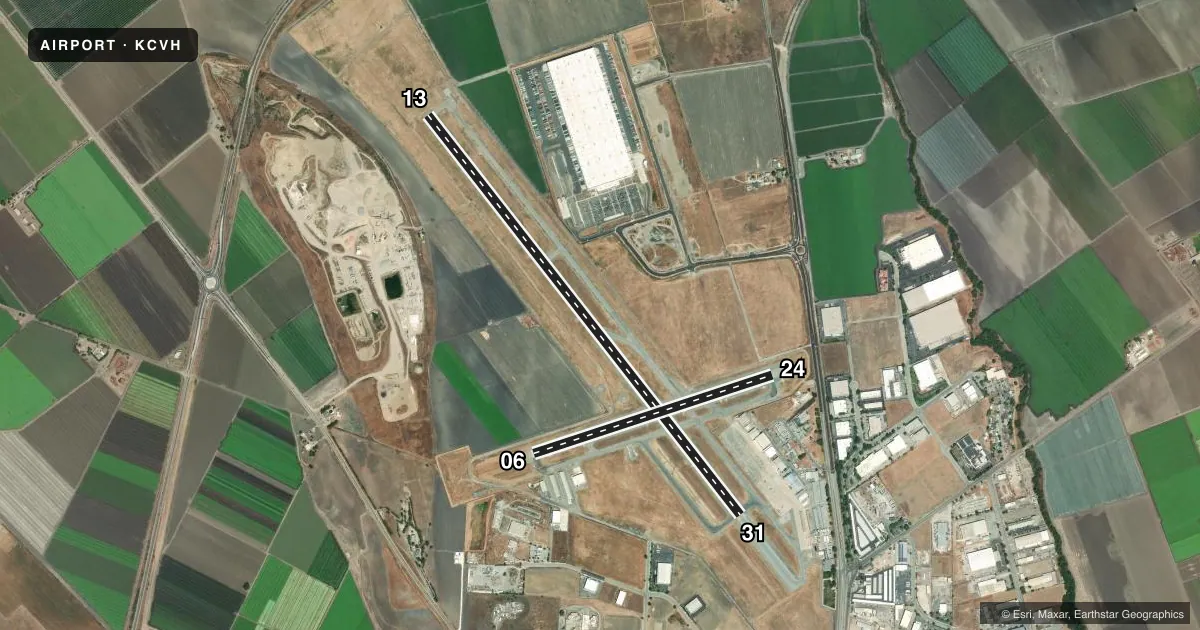
Runways & pattern
Full pagePattern entry · RWY 13
LEFT TRAFFIC| Runway | Heading (°M) | Length | Surface | Traffic |
|---|---|---|---|---|
| 13/31 | 127° / 307° | 6,350 ft | ASPH | Standard L |
| 06/24 | 57° / 237° | 3,149 ft | ASPH | Standard L |
Runway end performance
| End | TORA | TODA | ASDA | LDA | VGSI | Approach lights | Obstruction |
|---|---|---|---|---|---|---|---|
| 13 | — | — | — | — | PAPI 2-box left(3°) | — | — |
| 31 | — | — | — | — | PAPI 2-box left(3°) | — | — |
| 06 | — | — | — | — | — | — | 65', hill, 1700' from thr, 100' R of cntrln, slope 23 |
| 24 | — | — | — | — | VASI 2-box left(3.75°) | — | 15', road, 510' from thr, 0' R of cntrln, slope 20 |
Declared distances in feet. TORA = takeoff run available, TODA = takeoff distance, ASDA = accelerate-stop, LDA = landing distance.
Airport sketch
Runways drawn to scale from FAA survey coordinates, rendered over satellite imagery. Not for navigation.
Approaches & charts
Services on the field
Fuel grades, oxygen, maintenance, ramp storage and lighting — as declared to the FAA by the airport operator.
Fuel & services
- Fuel
- 100LLA
- Oxygen (bottled)
- Not available
- Oxygen (bulk)
- Not available
- Airframe repair
- Major
- Power plant repair
- Major
- Other services
- GLD,INSTR,RNTL,SALES
Ramp & ground
- Transient storage
- Tie-down
- Landing fee
- No fee published
- Customs
- Not available
- Lighting schedule
- SEE RMK
- Beacon schedule
- SS-SR
- Beacon
- White / Green (civil land)(WG)
- Wind indicator
- Lighted
- Segmented circle
- Yes
Fuel & FBOs
Cheapest 100LL and Jet A on the field and nearby. Always confirm with the FBO before taxi.
Airport notes
Surface conditions, obstructions, local procedures, lighting outages and other notes published with each FAA cycle.
General notes
- MODEL ACFT CLUB CONDUCTING FLT OPNS 3 MILES WNW OF ARPT HEADING OF 290 DEGREES FM ARPT SURFACE TO 500' AGL.
- CAUTION - WATCH FOR FIRE FIGHTING ACFT MAY THRU OCT.
- GLIDER ACTIVITY ON AND INVOF ARPT.
- RECOMMEND PILOTS TO BEGIN RY 31 TAKEOFF ROLL AT OR BEYOND THE THLD (PAST TAXIWAY B).
- FOR CD CTC NORCAL APCH AT 916-361-3748.
Lighting notes
- ACTVT REIL RWY 24, 13, & 31; VASI RWY 24; PAPI RWY 13 & 31; MIRL RWY 06/24 & 13/31 - CTAF.
Fuel notes
- 100LLFUEL AVBL 24 HRS CREDIT CARD LOCK SYSTEM.
Other notes
- TPA FOR HELICOPTERS 500 FT AGL.
- 1AMGR AT ARPT MON-FRI 0800-1500.
- MANAGERFAX (831)636-4366.
VFR map & nearby airports
VFR sectional. Tap any ICAO chip to open that airport.
Key facts · KCVH
Answer card- ICAO
- KCVH
- Name
- HOLLISTER MUNI
- Location
- HOLLISTER, CALIFORNIA
- Elevation
- 230.6 ft MSL
- Traffic pattern altitude
- 1,030.6 ft MSL (800 AGL)
- Control tower
- Non-towered (use CTAF)
- Total runways
- 2
- Longest runway
- 13/31 · 6,350 ft
- Published ILS approaches
- 0
- Published frequencies
- 4
- Magnetic variation
- 15°
- Current flight rules
- VFR
- Current wind
- 000° at 0 kt
- Favored runway now
- –
Hollister Muni sits in Hollister, California at 230.6 ft MSL. It has two asphalt runways. The longest is 13/31 at 6,350 ft. Runway 06/24 is 3,149 ft. There is no control tower. CTAF and UNICOM are both 123.0. NorCal Approach uses 124.525 and 348.675 for approach and departure services. No ILS approaches are published here.
Pattern altitude is 800 ft AGL, which is 1,030.6 ft MSL. Helicopters use 500 ft AGL. That matters here because the field has glider activity on and near the airport. There is also model aircraft activity 3 miles west-northwest of the field on a 290-degree line from the airport surface up to 500 ft AGL. Firefighting aircraft may also be in the area through October.
Hollister Jet Center is on the field. It carries 100LL, Jet A and Jet A Prist. Fuel is available 24 hours with a credit card lock system. Runway 24 has VASI. Runways 13 and 31 have PAPI. REIL is on runways 24, 13 and 31. If you are new to the airport, pay attention to the runway 31 note. The published remark says to begin the takeoff roll at or beyond the threshold past taxiway B.