METAR & TAF KSNS
Current METAR
Observed 12:53Z
KSNS 271253Z 28006KT 10SM OVC007 14/13 A3003 RMK AO2 SLP176 T01440128
- Wind
- 280° @ 6 kt
- Visibility
- 10 SM
- Temp / Dew
- 14°C / 13°C
- Altimeter
- 30.03 inHg
- Clouds
- OVC
- Density alt
- -152 ft
- Ceiling
- 700 ft AGL
- Rules
- IFR
Airport info & contacts
Manager on record, flight service, ARTCC, attendance schedule and pattern altitude — published by the FAA and refreshed every 28 days.
Location
- From city
- 3 NM SE
- VFR sectional
- SAN FRANCISCO
- Pattern altitude
- 800 ft AGL · 884 ft MSL
- ARTCC
- ZOA · OAKLAND
- NOTAM facility
- SNS (NOTAM-D)
Airport manager
- Name
- MATT NELSON
- Phone
- 831-758-7214
- Address
- 30 MORTENSEN AVE, SALINAS CA 93905
Flight service · Hours
- FSS OAK
- OAKLAND1-800-WX-BRIEF
- Attendance
- ALL
Frequencies
Tap any row to copy the frequency to your clipboard.
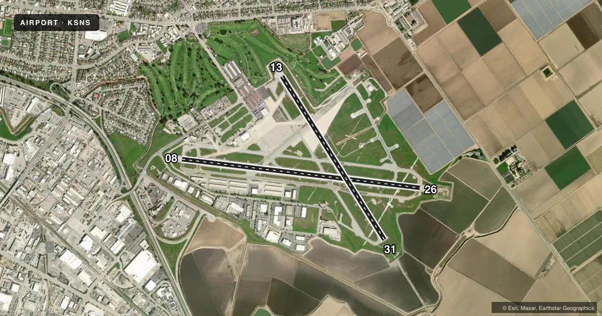
Runways & pattern
Full pagePattern entry · RWY 26
LEFT TRAFFIC| Runway | Heading (°M) | Length | Surface | Traffic |
|---|---|---|---|---|
| 08/26Favored | 84° / 264° | 6,004 ft | ASPH | 08 R |
| 13/31 | 135° / 315° | 4,825 ft | ASPH | 31 R |
Runway end performance
| End | TORA | TODA | ASDA | LDA | VGSI | Approach lights | Obstruction |
|---|---|---|---|---|---|---|---|
| 08 | — | — | — | — | VASI 2-box left(3°) | — | — |
| 26 | — | — | — | — | VASI 2-box left(3°) | — | — |
| 13 | — | — | — | — | VASI 4-box left(3°) | — | 45', trees, 1733' from thr, 310' R of cntrln, slope 34 |
| 31 | — | — | — | — | PAPI 2-box left(3°) | MALSR | — |
Declared distances in feet. TORA = takeoff run available, TODA = takeoff distance, ASDA = accelerate-stop, LDA = landing distance.
Airport sketch
Runways drawn to scale from FAA survey coordinates, rendered over satellite imagery. Not for navigation.
Approaches & charts
ILS · 1
Services on the field
Fuel grades, oxygen, maintenance, ramp storage and lighting — as declared to the FAA by the airport operator.
Fuel & services
- Fuel
- 100LLA
- Oxygen (bottled)
- High pressure
- Oxygen (bulk)
- Not available
- Airframe repair
- Major
- Power plant repair
- Major
- Other services
- AGRI,CHTR,INSTR,RNTL,SALES
Ramp & ground
- Transient storage
- Tie-down
- Hangar
- Landing fee
- No fee published
- Customs
- Not available
- Lighting schedule
- SEE RMK
- Beacon schedule
- SS-SR
- Beacon
- White / Green (civil land)(WG)
- Wind indicator
- Lighted
- Segmented circle
- No
Fuel & FBOs
Cheapest 100LL and Jet A on the field and nearby. Always confirm with the FBO before taxi.
Airport notes
Surface conditions, obstructions, local procedures, lighting outages and other notes published with each FAA cycle.
General notes
- PORTIONS OF TWY B BETWEEN D & N LIMITED ATCT SERVICES PROVIDED
- 6 FT TALL SECURITY FENCE 400 FT PRIOR TO RY 13 THLD ON CNTRLN AND STEEPLY DESCENDING TERRAIN 350 FT PRIOR TO RY 31 THLD ON CNTRLN BOTH IN RY 13/31 SAFETY AREA.
- FOR CD WHEN ATCT IS CLSD CTC NORCAL APCH AT 916-361-3748.
Lighting notes
- WHEN ATCT CLSD ACTVT MALSR RWY 31; REIL RWY 13 & 26; PAPI RWY 31; HIRL RWY 13/31; MIRL RWY 08/26; H1 - CTAF. VASI RWY 08, 13, & 26 OPR CONSLY.
Runway surface & condition
- 13/31200 FT ASPH STWY RY 31.
Other notes
- MANAGEREARLP@CI.SALINAS.CA.US
VFR map & nearby airports
VFR sectional. Tap any ICAO chip to open that airport.
Key facts · KSNS
Answer card- ICAO
- KSNS
- Name
- SALINAS MUNI
- Location
- SALINAS, CALIFORNIA
- Elevation
- 84.4 ft MSL
- Traffic pattern altitude
- 884.4 ft MSL (800 AGL)
- Control tower
- Towered · 0600-1900 OCT-MAR; 0500-1900 APR-SEP
- Total runways
- 2
- Longest runway
- 08/26 · 6,004 ft
- Published ILS approaches
- 1
- Published frequencies
- 10
- Magnetic variation
- 13°
- Current flight rules
- IFR
- Current wind
- 280° at 6 kt
- Favored runway now
- RWY 26
Salinas Muni is in Salinas, California. Field elevation is 84.4 ft MSL. The airport has two asphalt runways. The longest is runway 08/26 at 6,004 ft. Runway 13/31 is 4,825 ft. The tower is open 0600-1900 October through March. It is open 0500-1900 April through September.
There is one ILS approach on runway 31. Pattern altitude is 800 ft AGL, which is 884.4 ft MSL. The airport sits under NorCal Class C service, so plan for the usual radio work. Read back clearances carefully. GateOne Salinas is on the field. It carries 100LL, Jet A and Jet A Prist. If you need current ramp or fuel details, call them directly at (831) 422-9400.
A few published remarks matter here. When the tower is closed, runway 31 lighting is activated through the approach lighting system, with runway alignment indicator lights and a PAPI for runway 31. Runways 13 and 26 also have end identifier lights. There is a security fence near the runway 13 side. Steeply descending terrain is near the runway 31 side in the 13/31 safety area. Taxiway B between D and N has limited ATC services in spots. If you are arriving after tower hours, contact NorCal Approach for clearance delivery. Use the current Chart Supplement for any operational changes before you go.