METAR & TAF KKIC
KKIC does not publish a METAR.
Showing the nearest reporting station: KSNS (SALINAS MUNI) · 35.1 NM away. Conditions at KKIC may differ.
METAR · KSNS
Observed 16:53Z
KSNS 271653Z 31008KT 10SM CLR 18/13 A3004 RMK AO2 SLP181 T01830128
- Wind
- 310° @ 8 kt
- Visibility
- 10 SM
- Temp / Dew
- 18°C / 13°C
- Altimeter
- 30.04 inHg
- Clouds
- CLR
- Density alt
- 675 ft
- Ceiling
- Unlimited
- Rules
- VFR
Airport info & contacts
Manager on record, flight service, ARTCC, attendance schedule and pattern altitude — published by the FAA and refreshed every 28 days.
Location
- From city
- 1 NM NE
- VFR sectional
- SAN FRANCISCO
- Pattern altitude
- 800 ft AGL · 1,174 ft MSL
- ARTCC
- ZOA · OAKLAND
- NOTAM facility
- OAK (NOTAM-D)
Airport manager
- Name
- MARICRUZ AGUILAR
- Phone
- 831-233-0293
- Address
- 212 SOUTH VANDERHURST AVE, KING CITY CA 93930-2922
Flight service · Hours
- FSS OAK
- OAKLAND1-800-WX-BRIEF
- Attendance
- MON-FRI · 0800-1700
Frequencies
Tap any row to copy the frequency to your clipboard.
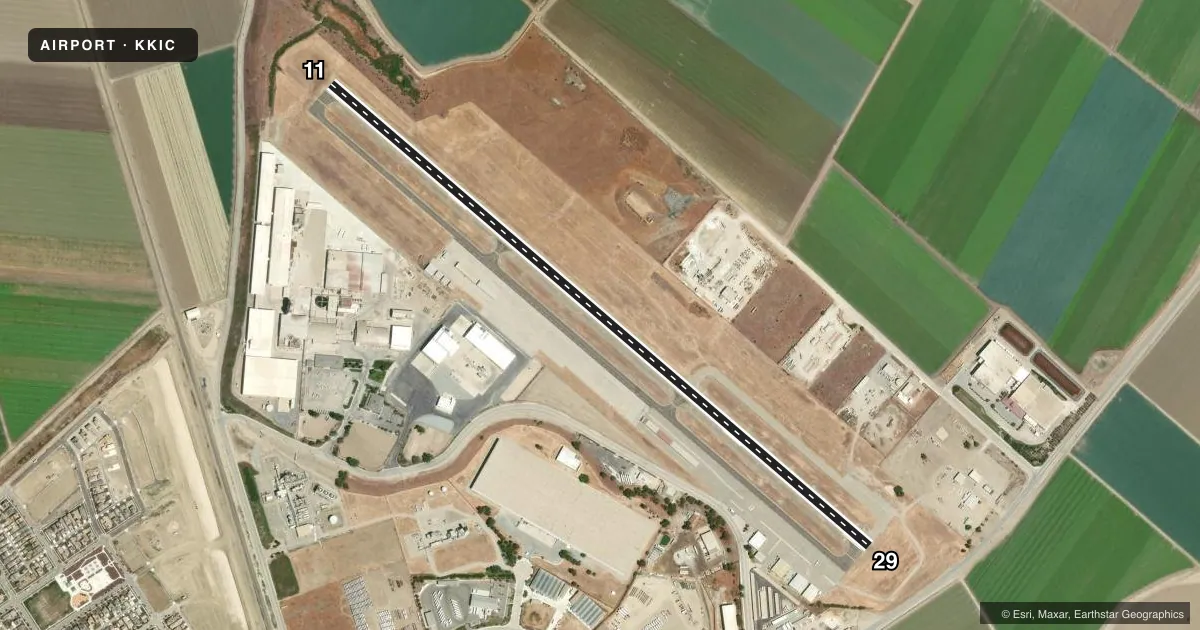
Runways & pattern
Full pagePattern entry · RWY 29
LEFT TRAFFICRunway end performance
| End | TORA | TODA | ASDA | LDA | VGSI | Approach lights | Obstruction |
|---|---|---|---|---|---|---|---|
| 11 | — | — | — | — | PAPI 2-box left(3.5°) | — | 4', berm, 280' from thr, 0' R of cntrln, slope 20 |
| 29 | — | — | — | — | PAPI 2-box left(3°) | — | 7', road, 400' from thr, 0' R of cntrln, slope 28 |
Declared distances in feet. TORA = takeoff run available, TODA = takeoff distance, ASDA = accelerate-stop, LDA = landing distance.
Airport sketch
Runways drawn to scale from FAA survey coordinates, rendered over satellite imagery. Not for navigation.
Approaches & charts
Services on the field
Fuel grades, oxygen, maintenance, ramp storage and lighting — as declared to the FAA by the airport operator.
Fuel & services
- Fuel
- 100LL
- Oxygen (bottled)
- Not available
- Oxygen (bulk)
- Not available
- Airframe repair
- Not available
- Power plant repair
- Not available
- Other services
- INSTR
Ramp & ground
- Transient storage
- Tie-down
- Landing fee
- No fee published
- Customs
- Not available
- Lighting schedule
- SS-SR
- Beacon schedule
- SS-SR
- Beacon
- White / Green (civil land)(WG)
- Wind indicator
- Lighted
- Segmented circle
- Yes
Fuel & FBOs
Cheapest 100LL and Jet A on the field and nearby. Always confirm with the FBO before taxi.
Airport notes
Surface conditions, obstructions, local procedures, lighting outages and other notes published with each FAA cycle.
General notes
- INTENSIVE AEROBATIC ACTIVITY INVOF AIRPORT.
- FOR CD CTC OAKLAND ARTCC AT 510-745-3380.
Fuel notes
- 100LLFUEL AVBL 24 HRS.
Other notes
- ESTBD PRIOR TO MAY 1959.
- MANAGERCITY MANAGER.
- MANAGERARPT PHONE 831-385-6575 - KING CITY AVN.
VFR map & nearby airports
VFR sectional. Tap any ICAO chip to open that airport.
Key facts · KKIC
Answer card- ICAO
- KKIC
- Name
- MESA DEL REY
- Location
- KING CITY, CALIFORNIA
- Elevation
- 374.2 ft MSL
- Traffic pattern altitude
- 1,174.2 ft MSL (800 AGL)
- Control tower
- Non-towered (use CTAF)
- Total runways
- 1
- Longest runway
- 11/29 · 4,479 ft
- Published ILS approaches
- 0
- Published frequencies
- 1
- Magnetic variation
- 15°
- Current flight rules
- VFR
- Current wind
- 310° at 8 kt
- Favored runway now
- RWY 29
Mesa Del Rey is in King City, California. The field elevation is 374.2 ft MSL. It has one runway. Runway 11/29 is 4,479 ft long with an asphalt surface. The airport is non-towered. CTAF is 122.9. The pattern altitude is 800 ft AGL, which is 1,174.2 ft MSL. No ILS approaches are published here.
King City Aviation is on the field. The published remarks say 100LL fuel is available 24 hours. The airport phone for King City Aviation is 831-385-6575. The remarks also note intensive aerobatic activity in the vicinity of the airport. That is worth planning around, especially if you are arriving VFR or doing local pattern work. Clearance delivery contact is Oakland ARTCC at 510-745-3380. The airport manager is the city manager. If you need current operational details, call the airport operator or the FBO directly before departure. This is a good field to brief carefully because the pattern is low at 800 ft AGL and there is no tower to separate traffic.