METAR & TAF 3O8
3O8 does not publish a METAR.
Showing the nearest reporting station: KHJO (HANFORD MUNI) · 29.8 NM away. Conditions at 3O8 may differ.
METAR · KHJO
Observed 15:53Z
KHJO 271553Z AUTO 33007KT 10SM CLR 24/08 A2999 RMK AO2 SLP154 T02440083
- Wind
- 330° @ 7 kt
- Visibility
- 10 SM
- Temp / Dew
- 24°C / 8°C
- Altimeter
- 29.99 inHg
- Clouds
- CLR
- Density alt
- 1,576 ft
- Ceiling
- Unlimited
- Rules
- VFR
Airport info & contacts
Manager on record, flight service, ARTCC, attendance schedule and pattern altitude — published by the FAA and refreshed every 28 days.
Location
- From city
- 9 NM NE
- VFR sectional
- SAN FRANCISCO
- ARTCC
- ZOA · OAKLAND
- NOTAM facility
- RIU (NOTAM-D)
Airport manager
- Name
- ROGER VANDERBERG
- Phone
- 559-935-0717
- Address
- 24505 W. DORIS AVE., COALINGA CA 93210-9667
Flight service · Hours
- FSS RIU
- RANCHO MURIETA1-800-WX-BRIEF
- Attendance
- 0600-1900
Frequencies
Tap any row to copy the frequency to your clipboard.
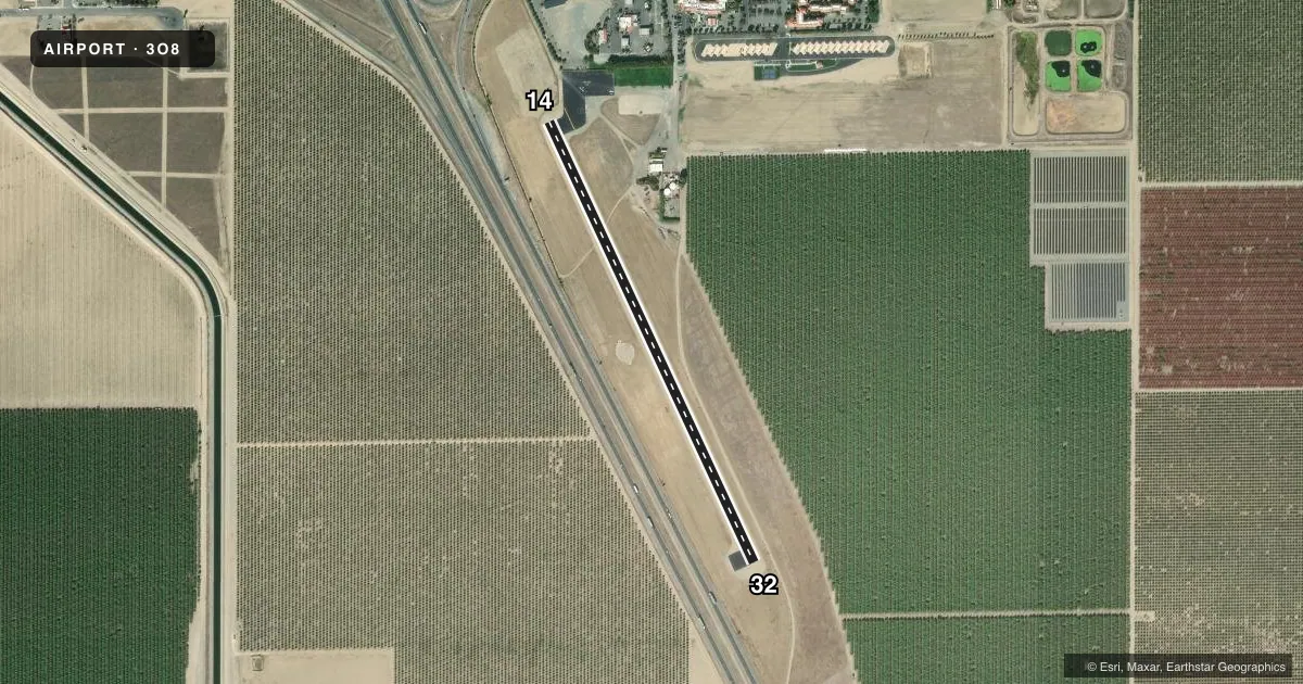
Runways & pattern
Full pagePattern entry · RWY 32
LEFT TRAFFICRunway end performance
| End | TORA | TODA | ASDA | LDA | VGSI | Approach lights | Obstruction |
|---|---|---|---|---|---|---|---|
| 14 | — | — | — | — | — | — | 48', pole, 1200' from thr, 30' R of cntrln, slope 20 |
| 32 | — | — | — | — | — | — | 40', pline, 1800' from thr, 0' R of cntrln, slope 40 |
Declared distances in feet. TORA = takeoff run available, TODA = takeoff distance, ASDA = accelerate-stop, LDA = landing distance.
Airport sketch
Runways drawn to scale from FAA survey coordinates, rendered over satellite imagery. Not for navigation.
Approaches & charts
Services on the field
Fuel grades, oxygen, maintenance, ramp storage and lighting — as declared to the FAA by the airport operator.
Fuel & services
- Fuel
- 100LL
Ramp & ground
- Transient storage
- Tie-down
- Landing fee
- No fee published
- Lighting schedule
- SS-SR
- Wind indicator
- Lighted
- Segmented circle
- Yes
Fuel & FBOs
Cheapest 100LL and Jet A on the field and nearby. Always confirm with the FBO before taxi.
Airport notes
Surface conditions, obstructions, local procedures, lighting outages and other notes published with each FAA cycle.
General notes
- CTN ELEC PWR LINE 40 FT AGL 0.3 NM S OF ARPT.
- NO RUN-UPS ON APCH END OF RWY 32.
- FOR CD CTC OAKLAND ARTCC AT 510-745-3380.
Fuel notes
- 100LLFUEL AVBL 24 HRS FM SERVICE STATION 559-935-0717.
Other notes
- OWNER24 HR PHONE AT OWNERS RESTAURANT 559-935-0717.
VFR map & nearby airports
VFR sectional. Tap any ICAO chip to open that airport.
Key facts · 3O8
Answer card- ICAO
- 3O8
- Name
- HARRIS RANCH
- Location
- COALINGA, CALIFORNIA
- Elevation
- 470 ft MSL
- Traffic pattern altitude
- 1,470 ft MSL (1,000 AGL)
- Control tower
- Non-towered (use CTAF)
- Total runways
- 1
- Longest runway
- 14/32 · 2,820 ft
- Published ILS approaches
- 0
- Published frequencies
- 1
- Magnetic variation
- 15°
- Current flight rules
- VFR
- Current wind
- 330° at 7 kt
- Favored runway now
- RWY 32
Harris Ranch (3O8) sits near Coalinga, California. The field elevation is 470 ft MSL. It has one runway. Runway 14/32 is 2,820 ft long and asphalt. There is no control tower. CTAF is 122.9. No ILS approaches are published here.
The pattern altitude is not published. Use the standard 1,000 ft AGL for light piston operations unless the current Chart Supplement says otherwise. Harris Ranch Inn & Restaurant is on the field. It carries 100LL. The published remarks also note 24-hour fuel service by phone at the restaurant number. For clearance delivery, Oakland ARTCC is listed in the remarks. That is useful if you need IFR handling before departure.
A first-time pilot should pay attention to the runway environment. No run-ups are permitted on the approach end of runway 32. There is also a power line about 40 ft AGL located 0.3 NM south of the airport. With no tower and one short runway, plan your arrival and departure carefully. Check the current Chart Supplement for any additional local procedures before you go.