METAR & TAF KPRB
Current METAR
Observed 12:53Z
KPRB 271253Z AUTO 32005KT 10SM CLR 14/11 A3005 RMK AO2 SLP167 T01390111
- Wind
- 320° @ 5 kt
- Visibility
- 10 SM
- Temp / Dew
- 14°C / 11°C
- Altimeter
- 30.05 inHg
- Clouds
- CLR
- Density alt
- 759 ft
- Ceiling
- Unlimited
- Rules
- VFR
Airport info & contacts
Manager on record, flight service, ARTCC, attendance schedule and pattern altitude — published by the FAA and refreshed every 28 days.
Location
- From city
- 4 NM NE
- VFR sectional
- LOS ANGELES
- ARTCC
- ZOA · OAKLAND
- NOTAM facility
- PRB (NOTAM-D)
Airport manager
- Name
- MARK W. SCANDALIS
- Phone
- 805-237-3877
- Address
- 4912 WING WAY, PASO ROBLES CA 93446
Flight service · Hours
- FSS HHR
- HAWTHORNE1-800-WX-BRIEF
- Attendance
- 0700-1800
Frequencies
Tap any row to copy the frequency to your clipboard.
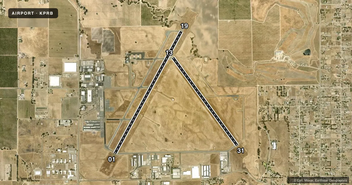
Runways & pattern
Full pagePattern entry · RWY 31
LEFT TRAFFIC| Runway | Heading (°M) | Length | Surface | Traffic |
|---|---|---|---|---|
| 01/19 | 14° / 194° | 6,008 ft | ASPH | Standard L |
| 13/31Favored | 129° / 309° | 4,701 ft | ASPH | Standard L |
Runway end performance
| End | TORA | TODA | ASDA | LDA | VGSI | Approach lights | Obstruction |
|---|---|---|---|---|---|---|---|
| 19 | — | — | — | — | PAPI 4-box left(3°) | — | — |
| 31 | — | — | — | — | PAPI 4-box left(3°) | — | 54', tree, 1950' from thr, 0' R of cntrln, slope 32 |
Declared distances in feet. TORA = takeoff run available, TODA = takeoff distance, ASDA = accelerate-stop, LDA = landing distance.
Airport sketch
Runways drawn to scale from FAA survey coordinates, rendered over satellite imagery. Not for navigation.
Approaches & charts
Services on the field
Fuel grades, oxygen, maintenance, ramp storage and lighting — as declared to the FAA by the airport operator.
Fuel & services
- Fuel
- 100LLA
- Oxygen (bottled)
- Low pressure
- Airframe repair
- Major
- Power plant repair
- Minor
- Other services
- INSTR,RNTL
Ramp & ground
- Transient storage
- Tie-down
- Landing fee
- No fee published
- Customs
- Not available
- Lighting schedule
- SEE RMK
- Beacon schedule
- SS-SR
- Beacon
- White / Green (civil land)(WG)
- Wind indicator
- Lighted
- Segmented circle
- Yes
Fuel & FBOs
Cheapest 100LL and Jet A on the field and nearby. Always confirm with the FBO before taxi.
Airport notes
Surface conditions, obstructions, local procedures, lighting outages and other notes published with each FAA cycle.
General notes
- PPR FOR AIRCRAFT OVER 80,000 LBS. CONTACT AMGR 805-237-3877
- RWY 19 DSGND CALM WIND RWY.
- FOR CD IF UNA TO CTC ON FSS FREQ, CTC OAKLAND ARTCC AT 510-745-3380.
- V22 OSPREY ARPT OPS RSTRD TO BTN 0700 TO 1530 LOCAL.
- V22 OSPREY OPS PPR RQRD.
Lighting notes
- RY LGTS OPER DUSK-2200; AFTER 2200 ACTVT HIRL RY 01/19 MIRL RY 13/31 PAPI RYS 19 & 31, RY H1 PERIMETER LGTS - CTAF.
Approach & departure obstructions
- H1STANDARD HELIPAD MARKINGS.
Other notes
- MSCANDALIS@PRCITY.COM
- 1FEE FOR CALL OUT SVC OTR HRS, 805-246-1443.
VFR map & nearby airports
VFR sectional. Tap any ICAO chip to open that airport.
Key facts · KPRB
Answer card- ICAO
- KPRB
- Name
- PASO ROBLES MUNI
- Location
- PASO ROBLES, CALIFORNIA
- Elevation
- 838.7 ft MSL
- Traffic pattern altitude
- 1,838.7 ft MSL (1,000 AGL)
- Control tower
- Non-towered (use CTAF)
- Total runways
- 2
- Longest runway
- 01/19 · 6,008 ft
- Published ILS approaches
- 0
- Published frequencies
- 2
- Magnetic variation
- 15°
- Current flight rules
- VFR
- Current wind
- 320° at 5 kt
- Favored runway now
- RWY 31
Paso Robles Muni sits in Paso Robles, California. The field elevation is 838.7 ft MSL. It has two asphalt runways. The longest is runway 01/19 at 6,008 ft. Runway 13/31 is 4,701 ft. There is no control tower, so expect CTAF and UNICOM self-announce traffic on 123.0. No ILS approaches are published here, so plan with the current charted procedures before you go.
Pattern altitude is not published. Use 1,000 ft AGL for light piston traffic unless the current Chart Supplement says otherwise. Loyd's Aviation is on the field. It carries 100LL and Jet A. The published remarks matter here. Runway lights operate from dusk to 2200. After 2200, pilots need to activate the lights on CTAF. Runway 19 is the calm wind runway. V22 Osprey operations are restricted to 0700 to 1530 local time and require prior permission. Aircraft over 80,000 pounds also need prior permission. If you need after-hours call out service, check with the field directly before you launch. For a first-time arrival, the big thing is to plan for an uncontrolled field with published lighting procedures and no ILS backup.