METAR & TAF KSBP
Current METAR
Observed 05:56Z
KSBP 260556Z AUTO 29003KT 10SM CLR 16/12 A2995 RMK AO2 SLP138 T01560122 10239 20156 51009
- Wind
- 290° @ 3 kt
- Visibility
- 10 SM
- Temp / Dew
- 16°C / 12°C
- Altimeter
- 29.95 inHg
- Clouds
- CLR
- Density alt
- 346 ft
- Ceiling
- Unlimited
- Rules
- VFR
Airport info & contacts
Manager on record, flight service, ARTCC, attendance schedule and pattern altitude — published by the FAA and refreshed every 28 days.
Location
- From city
- 3 NM S
- VFR sectional
- LOS ANGELES
- ARTCC
- ZLA · LOS ANGELES
- NOTAM facility
- SBP (NOTAM-D)
Airport manager
- Name
- COURTNEY JOHNSON
- Phone
- 805-781-5218
- Address
- 975 AIRPORT DRIVE, SUITE 1, SAN LUIS OBISPO CA 93401
Flight service · Hours
- FSS HHR
- HAWTHORNE1-800-WX-BRIEF
- Attendance
- 0600-1700
Frequencies
Tap any row to copy the frequency to your clipboard.
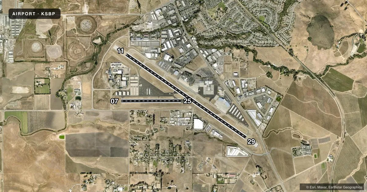
Runways & pattern
Full pagePattern entry · RWY 29
LEFT TRAFFIC| Runway | Heading (°M) | Length | Surface | Traffic |
|---|---|---|---|---|
| 11/29Favored | 110° / 290° | 6,101 ft | ASPH | Standard L |
| 07/25 | 75° / 255° | 2,500 ft | ASPH | Standard L |
Runway end performance
| End | TORA | TODA | ASDA | LDA | VGSI | Approach lights | Obstruction |
|---|---|---|---|---|---|---|---|
| 11 | 6,100' | 6,100' | 6,100' | 5,300' | VASI 4-box left(3°) | MALSR | — |
| 29 | 6,100' | 6,100' | 6,100' | 5,600' | VASI 4-box left(3.25°) | — | — |
| 07 | 2,500' | 2,500' | 2,500' | 2,500' | — | — | 10', road, 410' from thr, slope 21 |
| 25 | 2,500' | 2,500' | 2,500' | 2,500' | — | — | — |
Declared distances in feet. TORA = takeoff run available, TODA = takeoff distance, ASDA = accelerate-stop, LDA = landing distance.
Airport sketch
Runways drawn to scale from FAA survey coordinates, rendered over satellite imagery. Not for navigation.
Approaches & charts
ILS · 1
Services on the field
Fuel grades, oxygen, maintenance, ramp storage and lighting — as declared to the FAA by the airport operator.
Fuel & services
- Fuel
- 100LLA
- Oxygen (bottled)
- HIGH/LOW
- Oxygen (bulk)
- High pressure
- Airframe repair
- Major
- Power plant repair
- Major
- Other services
- AFRT,AVNCS,CARGO,CHTR,INSTR,RNTL,SALES,SURV
Ramp & ground
- Transient storage
- Tie-down
- Landing fee
- No fee published
- Customs
- Not available
- Lighting schedule
- SEE RMK
- Beacon schedule
- SS-SR
- Beacon
- White / Green (civil land)(WG)
- Wind indicator
- Lighted
- Segmented circle
- Yes
Fuel & FBOs
Cheapest 100LL and Jet A on the field and nearby. Always confirm with the FBO before taxi.
Airport notes
Surface conditions, obstructions, local procedures, lighting outages and other notes published with each FAA cycle.
General notes
- RECURRING FLOCKS OF WATERFOWL ON AND IN VICINITY OF ARPT DURG WINTER MONTHS.
- TAXILANE WIDTHS LESS THAN STANDARD.
- NOISE SENSITIVE ARPT; TCH 50 FT; FOR NOISE ABATEMENT INFO CTC AMGR (805) 781-5205.
- RY 29 DESIGNATED CALM WIND RY.
- ATCT UNABLE TO SEE ACFT IN HOLDING BAY AT NW END OF TWY A. MOVEMENT FM HOLDING BAY REQUIRES ATCT APVL DURG ATCT HRS.
- TRANSIENT PARKING EXCEEDING 2 HRS CTC FBO EXCEPT FOR AIR CARRIERS.
- PUSHBACK FM TRML GATES AT PILOT'S DISCRETION. DO NOT CALL GND CTL FOR PUSHBACK.
- TWY A RUN-UP AREA FOR RWY 29, JETS USE MNM BREAKAWAY PWR.
- TWY A BTN TWYS C AND F WILL BE PDCLY RSTRD FOR ACFT WITH WINGSPAN OF 79 FT OR GTR DRG OPNS ON RWY 11/29.
Lighting notes
- ACTVT MALSR RWY 11; REIL RWY 29; VASI RWY 11; HIRL RWY 11/29 - CTAF. VASI RWY 29 OPR CONSLY.
Runway surface & condition
- 07/25PCR VALUE: 90/F/D/X/T
- 11/29PCR VALUE: 390/F/D/X/T
- 07/25RWY 07/25 NOT AVBL FOR PART 121/PART 380 OPS WITH SKED PAX CARRYING OPS MORE THAN 9 PAX SEATS AND NON-SKED PAX CARRYING OPS MORE THAN 30 PAX SEATS.
- 11/29BLAST PAD DEP END RY 11: 600 FT X 200 FT. BLAST PAD DEP END RY 29: 600 FT X 200 FT.
Approach & departure obstructions
- 11RWY 11 VASI UNUSBL BYD 5 DEGS RIGHT OF RWY CNTRLN.
Arresting gear
- 11_EMASENGINEERED MATERIAL ARRESTING SYSTEM (EMAS) 300 FT IN LENGTH BY 170 FT IN WIDTH LCTD AT THE DER 11.
- 29_EMASENGINEERED MATERIAL ARRESTING SYSTEM (EMAS) 312 FT IN LENGTH BY 170 FT IN WIDTH LCTD AT THE DER 29.
Other notes
- PRIOR TO 15 MAY 1959.
- REFIL CUSTOMER BOTTLE.
- TPA 991 AGL SINGLE ENG; 1491 AGL MULTI-ENG, JET & HIGH PER.
- TSNT TIE DWN PRKING AVBL W SIDE, ADJ SLF SERVE FUEL FACILITY
- MANAGERDEPUTY DIR: TIM O'KEEFFE 805-788-2000.
VFR map & nearby airports
VFR sectional. Tap any ICAO chip to open that airport.
Key facts · KSBP
Answer card- ICAO
- KSBP
- Name
- SAN LUIS OBISPO COUNTY RGNL
- Location
- SAN LUIS OBISPO, CALIFORNIA
- Elevation
- 212.3 ft MSL
- Traffic pattern altitude
- 1,212.3 ft MSL (1,000 AGL)
- Control tower
- Towered · 0600-2000
- Total runways
- 2
- Longest runway
- 11/29 · 6,101 ft
- Published ILS approaches
- 1
- Published frequencies
- 8
- Magnetic variation
- 15°
- Current flight rules
- VFR
- Current wind
- 290° at 3 kt
- Favored runway now
- RWY 29
San Luis Obispo County Rgnl is in San Luis Obispo, California. Field elevation is 212.3 ft MSL. The airport has two asphalt runways. The longest is runway 11/29 at 6,101 ft. Runway 07/25 is 2,500 ft.
The field is towered. The control tower is open 0600-2000. One ILS approach is published for runway 11. Pattern altitude is not published in the usual way, so use the Chart Supplement remarks. Single-engine traffic uses 991 ft AGL. Multi-engine, jet and high performance traffic uses 1,491 ft AGL.
ACI Jet is on the field. It carries 100LL, Jet A and Jet A Prist. Call them at (805) 548-1350 for current service details. The remarks also note that taxiway widths are less than standard. Taxiways southwest of runway 11/29 are closed to aircraft operations. That matters for taxi planning on the ground. Runway 29 is the calm wind runway. Winter waterfowl are also a recurring factor here. Keep a sharp scan on taxi, takeoff and landing.
For a first-time arrival, the big picture is simple. Expect a controlled airport with local procedures. Expect a single ILS on 11. Runway 29 is the calm wind choice. The tower cannot see aircraft in the holding bay at the northwest end of taxiway A. Get tower approval before moving from that area during tower hours.