METAR & TAF L52
L52 does not publish a METAR.
Showing the nearest reporting station: KSBP (SAN LUIS OBISPO COUNTY RGNL) · 8.2 NM away. Conditions at L52 may differ.
METAR · KSBP
Observed 12:56Z
KSBP 271256Z 31004KT 1/4SM FG VV002 12/12 A2998 RMK AO2 SLP150 T01220117
- Wind
- 310° @ 4 kt
- Visibility
- 0.25 SM
- Temp / Dew
- 12°C / 12°C
- Altimeter
- 29.98 inHg
- Clouds
- VV
- Density alt
- -417 ft
- Ceiling
- 200 ft AGL
- Rules
- LIFR
Airport info & contacts
Manager on record, flight service, ARTCC, attendance schedule and pattern altitude — published by the FAA and refreshed every 28 days.
Location
- From city
- 1 NM W
- VFR sectional
- LOS ANGELES
- Pattern altitude
- 986 ft AGL · 1,000 ft MSL
- ARTCC
- ZLA · LOS ANGELES
- NOTAM facility
- HHR (NOTAM-D)
Airport manager
- Name
- COURTNEY JOHNSON
- Phone
- 805-781-5218
- Address
- 975 AIRPORT DRIVE, SUITE 1, SAN LUIS OBISPO CA 93401-8417
Flight service · Hours
- FSS HHR
- HAWTHORNE1-800-WX-BRIEF
- Attendance
- Unattended
Frequencies
Tap any row to copy the frequency to your clipboard.
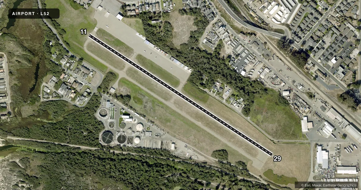
Runways & pattern
Full pagePattern entry · RWY 29
LEFT TRAFFICRunway end performance
| End | TORA | TODA | ASDA | LDA | VGSI | Approach lights | Obstruction |
|---|---|---|---|---|---|---|---|
| 11 | — | — | — | — | — | — | 8', brush, 380' from thr, 80' R of cntrln, slope 22 |
| 29 | — | — | — | — | — | — | 15', trees, 506' from thr, 53' R of cntrln, slope 20 |
Declared distances in feet. TORA = takeoff run available, TODA = takeoff distance, ASDA = accelerate-stop, LDA = landing distance.
Airport sketch
Runways drawn to scale from FAA survey coordinates, rendered over satellite imagery. Not for navigation.
Approaches & charts
Services on the field
Fuel grades, oxygen, maintenance, ramp storage and lighting — as declared to the FAA by the airport operator.
Fuel & services
- Fuel
- 100LL
- Oxygen (bottled)
- Not available
- Oxygen (bulk)
- Not available
- Other services
- CHTR,INSTR,RNTL
Ramp & ground
- Transient storage
- Tie-down
- Landing fee
- No fee published
- Customs
- Not available
- Lighting schedule
- SEE RMK
- Beacon schedule
- SEE RMK
- Beacon
- White / Green (civil land)(WG)
- Wind indicator
- Lighted
- Segmented circle
- Yes
Fuel & FBOs
Cheapest 100LL and Jet A on the field and nearby. Always confirm with the FBO before taxi.
Airport notes
Surface conditions, obstructions, local procedures, lighting outages and other notes published with each FAA cycle.
General notes
- UNSFCD AREAS SOFT AND UNUSBL.
- RECURRING FLOCKS OF WATERFOWL ON AND INVOF ARPT.
- ULTRALIGHT ACT ON AND INVOF ARPT.
- BE ALERT FOR KITES FLOWN ALONG BEACH 1/2 MILE W OF RWY.
- TAXILANES VERY NRW NR BLDGS & PARKED ACFT.
- EXTREMELY NOISE SENSITIVE ARPT & COMMUNITY; FOR TKOF RWY 29 PILOTS ARE REQD TO MNTN RWY HDG TIL XNG THE SHORELINE.
- TWY LGTS AT EXIT ONLY.
- FOR CD CTC LOS ANGELES ARTCC AT 661-575-2079.
Lighting notes
- DUSK-DAWN.
- ACTVT MIRL RWY 11/29 - CTAF.
Fuel notes
- 100LLSELF SVC FUEL AVBL 24 HRS.
Other notes
- ARPT LCTD 2 SM S OF PISMO BEACH.
- MANAGERCOUNTY AIRPORT MANAGER LOCATED IN SAN LUIS OBISPO.
- OWNERC.A.E.
- MANAGERPHONE AT ARPT 805-788-2000
VFR map & nearby airports
VFR sectional. Tap any ICAO chip to open that airport.
Key facts · L52
Answer card- ICAO
- L52
- Name
- OCEANO COUNTY
- Location
- OCEANO, CALIFORNIA
- Elevation
- 14 ft MSL
- Traffic pattern altitude
- 1,000 ft MSL (986 AGL)
- Control tower
- Non-towered (use CTAF)
- Total runways
- 1
- Longest runway
- 11/29 · 2,325 ft
- Published ILS approaches
- 0
- Published frequencies
- 2
- Magnetic variation
- 15°
- Current flight rules
- LIFR
- Current wind
- 310° at 4 kt
- Favored runway now
- RWY 29
Oceano County Airport (L52) is in Oceano, California, about 2 statute miles south of Pismo Beach. Field elevation is 14 ft MSL. The airport has one runway, 11/29, which is 2,325 ft long. There is no control tower. CTAF and UNICOM are both 122.7.
No ILS approaches are published here. Pattern altitude is 986 ft AGL, which is 1,000 ft MSL. The field sits in a very noise-sensitive coastal area. For runway 29 departures, pilots are required to hold runway heading until crossing the shoreline. That matters here. Ultralight activity is on and near the airport. Kites may also be flown along the beach about one half mile west of the runway.
ACI Jet - Oceano is on the field. It carries AVGAS 100LL. Unspecified areas are soft and unusable. Taxilanes are very narrow near buildings and parked aircraft, so taxi slowly and keep a close eye on wing clearance. Taxiway lights are at exit only. The beacon runs from dusk to dawn. If you need clearance delivery, contact Los Angeles ARTCC at 661-575-2079. For a first visit, plan for a busy low-level environment and verify current airport details with the airport operator or the current FAA Chart Supplement before you go.