METAR & TAF KSBA
Current METAR
Observed 10:53Z
KSBA 261053Z 00000KT 5SM BR CLR 18/17 A2991 RMK AO2 SLP127 T01830167 $
- Wind
- 000° @ 0 kt
- Visibility
- 5 SM
- Temp / Dew
- 18°C / 17°C
- Altimeter
- 29.91 inHg
- Clouds
- CLR
- Density alt
- 389 ft
- Ceiling
- Unlimited
- Rules
- MVFR
Airport info & contacts
Manager on record, flight service, ARTCC, attendance schedule and pattern altitude — published by the FAA and refreshed every 28 days.
Location
- From city
- 7 NM W
- VFR sectional
- LOS ANGELES
- ARTCC
- ZLA · LOS ANGELES
- NOTAM facility
- SBA (NOTAM-D)
Airport manager
- Name
- CHRISTOPHER HASTERT
- Phone
- 805-967-7111
- Address
- 601 FIRESTONE RD, SANTA BARBARA CA 93117
Flight service · Hours
- FSS HHR
- HAWTHORNE1-800-WX-BRIEF
- Attendance
- 0600-2300
Frequencies
Tap any row to copy the frequency to your clipboard.
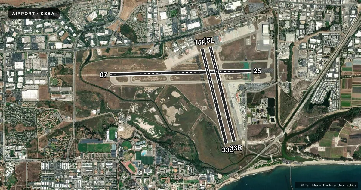
Runways & pattern
Full pagePattern entry · RWY 07
RIGHT TRAFFIC| Runway | Heading (°M) | Length | Surface | Traffic |
|---|---|---|---|---|
| 07/25 | 75° / 255° | 6,052 ft | ASPH | 07 R |
| 15R/33L | 152° / 332° | 4,184 ft | ASPH | 33L R |
| 15L/33R | 152° / 332° | 4,180 ft | ASPH | 33R R |
Runway end performance
| End | TORA | TODA | ASDA | LDA | VGSI | Approach lights | Obstruction |
|---|---|---|---|---|---|---|---|
| 07 | 6,052' | 6,052' | 6,052' | 6,052' | — | MALSR | 77', tree, 3100' from thr, 350' R of cntrln, slope 37 |
| 25 | 6,052' | 6,052' | 6,052' | 6,052' | PAPI 4-box left(3°) | — | 6', fence, 275' from thr, 0' R of cntrln, slope 12 |
| 15R | 4,184' | 4,184' | 4,184' | 4,184' | — | — | 53', tree, 600' from thr, 200' R of cntrln, slope 8 |
| 33L | 4,184' | 4,184' | 4,184' | 4,184' | — | — | 65', tree, 1300' from thr, 400' R of cntrln, slope 17 |
| 15L | 4,180' | 4,180' | 4,180' | 3,963' | — | — | 37', bldg, 900' from thr, 4' R of cntrln, slope 19 |
| 33R | 4,180' | 4,180' | 4,180' | 4,180' | — | — | — |
Declared distances in feet. TORA = takeoff run available, TODA = takeoff distance, ASDA = accelerate-stop, LDA = landing distance.
Airport sketch
Runways drawn to scale from FAA survey coordinates, rendered over satellite imagery. Not for navigation.
Approaches & charts
ILS · 1
Services on the field
Fuel grades, oxygen, maintenance, ramp storage and lighting — as declared to the FAA by the airport operator.
Fuel & services
- Fuel
- 100LLA
- Oxygen (bottled)
- HIGH/LOW
- Oxygen (bulk)
- HIGH/LOW
- Airframe repair
- Major
- Power plant repair
- Major
- Other services
- AFRT,AGRI,AVNCS,CARGO,CHTR,INSTR,SALES
Ramp & ground
- Transient storage
- Tie-down
- Landing fee
- Yes
- Customs
- Not available
- Lighting schedule
- SEE RMK
- Beacon schedule
- SS-SR
- Beacon
- White / Green (civil land)(WG)
- Wind indicator
- Lighted
- Segmented circle
- Yes
Fuel & FBOs
Cheapest 100LL and Jet A on the field and nearby. Always confirm with the FBO before taxi.
Airport notes
Surface conditions, obstructions, local procedures, lighting outages and other notes published with each FAA cycle.
General notes
- NUMEROUS FLOCKS OF BIRDS ON AND INVOF ARPT.
- PURE JET TOUCH/GO OR LOW APCHS PROHIBITED.
- DUE TO LMTD RAMP SPACE AT THE AIRLINE TRML NON-SKED TRNSP CAT ACFT WITH MORE THAN 30 PASSENGER SEATS ARE RQRD TO CTC ARPT OPNS 805-681-4803 24 HRS PRIOR TO ARR.
- NOISE ABATEMENT PROCS IN EFCT CTC ARPT OPNS 805-692-6025.
- RWY 15L/33R DALGT HRS ONLY.
- COML AIRLINE RAMP CLSD TO ALL GA ACFT.
- NO CUSTOMS PSNL OR FACS ARE AVBL AND INTL ACFT WILL NOT BE ALLOWED TO LAND UNLESS AN EMERG EXISTS.
- ALL ACR ACFT CTC ATC ON FREQ 121.7 PRIOR TO PUSHBACK FROM TRML RAMP AND RON PRKG 0600-2300. ESCORTS RQRD FROM RON PRKG WHEN ATC IS CLSD; CTC ARPT OPS 805-681-4803.
Lighting notes
- WHEN ATCT CLSD ACTVT MALSR RWY 07; REIL RWYS 15R & 25; HIRL RWY 07/25; MIRL RWY 15R/33L - CTAF. PAPI RWY 25 OPR CONSLY.
Fuel notes
- 100LL100LL FUEL 24 HR CREDIT CARD SVC AVBL.
- AFEE FOR JET A FUEL AFTER HRS CALL (805) 454-0051 OR 967-5608.
Runway surface & condition
- 07/25PCR VALUE: 658/F/D/X/T
- 15L/33RPCR VALUE: 45/F/D/X/T
- 15R/33LPCR VALUE: 45/F/D/X/T
- 15L/33RRWY 15L/33R NOT AVBL FOR PART 121/PART 380 OPS WITH SKED PAX CARRYING OPS MORE THAN 9 PAX SEATS AND NON-SKED PAX CARRYING OPS MORE THAN 30 PAX SEATS.
- 15R/33LRWY 15R/33L NOT AVBL FOR PART 121/PART 380 OPS WITH SKED PAX CARRYING OPS MORE THAN 9 PAX SEATS AND NON-SKED PAX CARRYING OPS MORE THAN 30 PAX SEATS.
Other notes
- LDG FEE FOR PART 135 OPRS AND TSNT ACFT WITH MAX GWT OF 10000 LBS OR MORE. FEES WILL BE BILLED/MAILED.
- TPA 990 FT SML ACFT; 1490 FT LRG ACFT.
- MANAGERMICHAEL SMITH - OPS MGR - MJSMITH@SANTABARBARACA.GOV
VFR map & nearby airports
VFR sectional. Tap any ICAO chip to open that airport.
Key facts · KSBA
Answer card- ICAO
- KSBA
- Name
- SANTA BARBARA MUNI
- Location
- SANTA BARBARA, CALIFORNIA
- Elevation
- 13.5 ft MSL
- Traffic pattern altitude
- 1,013.5 ft MSL (1,000 AGL)
- Control tower
- Towered · 0600-2300
- Total runways
- 3
- Longest runway
- 07/25 · 6,052 ft
- Published ILS approaches
- 1
- Published frequencies
- 21
- Magnetic variation
- 14°
- Current flight rules
- MVFR
- Current wind
- 000° at 0 kt
- Favored runway now
- –
Santa Barbara Muni sits in Santa Barbara, California, right on the coast. Field elevation is 13.5 ft MSL. The airport has 3 asphalt runways. The longest is runway 07/25 at 6,052 ft. The airport is towered from 0600 to 2300. One ILS approach is published for runway 07.
Pattern altitude is not published in the facts. Use the current FAA Chart Supplement before flying the pattern. This field sits in Class C airspace. Expect normal SoCal traffic flow and stay sharp on radio work.
Signature Aviation and Atlantic Aviation are on the field. Both carry 100LL and Jet A. Runway 15L/33R is daylight only. Noise abatement procedures are in effect. Contact airport operations before arrival if you need the current local guidance. The remarks also say birds are numerous on and near the airport. That matters here. Keep a close scan on climbout, approach and taxi.
The commercial airline ramp is closed to all general aviation aircraft. Air traffic control contact is required on 121.7 before pushback from the terminal ramp. International arrivals are not allowed because no customs personnel or facilities are available. If you are bringing a larger aircraft or planning overnight parking, check the published remarks and call airport operations first.