METAR & TAF KOXR
Current METAR
Observed 10:51Z
KOXR 271051Z AUTO 00000KT 9SM CLR 19/16 A2990 RMK AO2 SLP125 T01890161
- Wind
- 000° @ 0 kt
- Visibility
- 9 SM
- Temp / Dew
- 19°C / 16°C
- Altimeter
- 29.90 inHg
- Clouds
- CLR
- Density alt
- 560 ft
- Ceiling
- Unlimited
- Rules
- VFR
Airport info & contacts
Manager on record, flight service, ARTCC, attendance schedule and pattern altitude — published by the FAA and refreshed every 28 days.
Location
- From city
- 1 NM W
- VFR sectional
- LOS ANGELES
- ARTCC
- ZLA · LOS ANGELES
- NOTAM facility
- OXR (NOTAM-D)
Airport manager
- Name
- KEITH FREITAS
- Phone
- 805-388-4372
- Address
- 2889 W 5TH ST, OXNARD CA 93030
Flight service · Hours
- FSS HHR
- HAWTHORNE1-800-WX-BRIEF
- Attendance
- 0500-0030
Frequencies
Tap any row to copy the frequency to your clipboard.
Runways & pattern
Full pagePattern entry · RWY 07
LEFT TRAFFICRunway end performance
| End | TORA | TODA | ASDA | LDA | VGSI | Approach lights | Obstruction |
|---|---|---|---|---|---|---|---|
| 07 | 5,953' | 5,953' | 5,654' | 5,654' | PAPI 4-box right(3°) | — | — |
| 25 | 5,953' | 5,953' | 5,953' | 5,500' | PAPI 4-box left(3°) | MALSF | 70', pole, 2300' from thr, 210' R of cntrln, slope 30 |
Declared distances in feet. TORA = takeoff run available, TODA = takeoff distance, ASDA = accelerate-stop, LDA = landing distance.
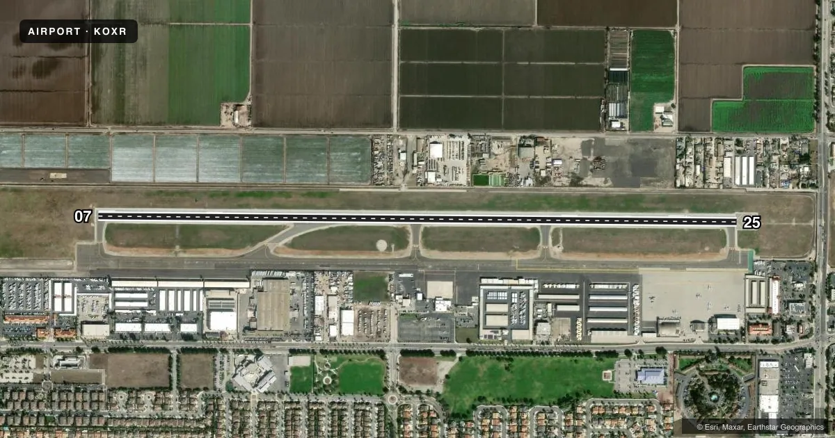
Airport sketch
Runways drawn to scale from FAA survey coordinates, rendered over satellite imagery. Not for navigation.
Approaches & charts
ILS · 1
Services on the field
Fuel grades, oxygen, maintenance, ramp storage and lighting — as declared to the FAA by the airport operator.
Fuel & services
- Fuel
- 100LLA
- Oxygen (bottled)
- Not available
- Oxygen (bulk)
- HIGH/LOW
- Airframe repair
- Major
- Power plant repair
- Major
- Other services
- AFRT,AGRI,CARGO,CHTR,INSTR,PAJA,RNTL,SALES
Ramp & ground
- Transient storage
- Tie-down
- Customs
- Not available
- Lighting schedule
- SEE RMK
- Beacon schedule
- SS-SR
- Beacon
- White / Green (civil land)(WG)
- Wind indicator
- Lighted
- Segmented circle
- Yes
Fuel & FBOs
Cheapest 100LL and Jet A on the field and nearby. Always confirm with the FBO before taxi.
Airport notes
Surface conditions, obstructions, local procedures, lighting outages and other notes published with each FAA cycle.
General notes
- NO TOUCH & GO, STOP & GO, OR TAXI BACK OPNS 2000-0700 LCL AFTER THREE CONSECUTIVE PATS, THEN TAXI BACK ONLY.
- ARPT OPNS LCTD AT BASE OF ATCT; CTC ON 134.95 WHEN ATCT CLSD OR CALL 805-947-6804.
- FLY FRIENDLY PROCS IN EFCT. AVOID HIGH PWR SETTINGS OVER RESIDENTIAL AREA. KEEP DNWND NORTH OF WOOLEY RD. TURN LEFT CROSSWIND LEG BFR CANAL OR FLY 1/2 MILE PAST SHORELINE. EXP RIGHT TFC RWY 25. SEE ARPT WEBSITE FOR FULL PROC.
- WILDLIFE ON AND INVOF AIRPORT.
- ARPT OPNS SUPVR ADDNL CTC DIR OF ARPTS - (805) 388-4200.
- PRCHT JUMPING SW CORNER OF ARPT.
Lighting notes
- WHEN ATCT CLSD, ACTVT MALSF RWY 25, REIL RWY 07, MIRL RWY 07-25 - CTAF.
Runway surface & condition
- 07/25PCR VALUE: 371/F/D/X/T
Approach & departure obstructions
- 07UPON REQUEST.
- 2545:1 DSPLCD THR. 123 FT AGL SPIRE DSPLCD 200 FT LEFT.
Other notes
- UNSKED ACR OPNS INVOLVING ACFT WITH MORE THAN 9 PAX SEATS ARE NOT AUTHD WO PRIOR COORD WITH ARPT AND CFMN THAT ARFF SVCS ARE AVBL PRIOR TO LDG OR TKOF, CTC 805-947-6804.
- <LANDING FEE OVER 12500 LBS.
- TPA 1000 AGL SNGL ENG; 1400 AGL MULTI-ENG & JETS.
- MANAGERARPT OPNS SUPVR. ADDNL CTC DIR OF ARPTS - KEITH FREITAS 805-388-4200.
- PAJAPARACHUTE ACT AT SW END OF ARPT.
VFR map & nearby airports
VFR sectional. Tap any ICAO chip to open that airport.
Key facts · KOXR
Answer card- ICAO
- KOXR
- Name
- OXNARD
- Location
- OXNARD, CALIFORNIA
- Elevation
- 44.8 ft MSL
- Traffic pattern altitude
- 1,044.8 ft MSL (1,000 AGL)
- Control tower
- Towered · 0700-2100
- Total runways
- 1
- Longest runway
- 07/25 · 5,953 ft
- Published ILS approaches
- 1
- Published frequencies
- 7
- Magnetic variation
- 15°
- Current flight rules
- VFR
- Current wind
- 000° at 0 kt
- Favored runway now
- –
OXNARD is in Oxnard, California. The field elevation is 44.8 ft MSL. It has one runway, 07/25, which is 5,953 ft long and paved with asphalt. The tower is open daily from 0700 to 2100. The airport has one ILS approach. It serves runway 25. Pattern altitude is published at 1,000 ft AGL for single-engine aircraft. It is 1,400 ft AGL for multi-engine aircraft and jets.
Two on-field FBOs are confirmed here. Oxnard Aircraft & Jet Center carries 100LL, Jet A and Jet A Prist. Axis Air carries 100LL, Jet A and Jet A Prist. When the tower is closed, use CTAF 134.95 and follow the published lighting activation for runway 25, runway 07 and the MIRL system. The published remarks also call for fly-friendly procedures. Keep power settings down over residential areas. Expect right traffic for runway 25. Wildlife is reported on and near the airport, so keep a sharp scan on taxi, takeoff and landing. The field sits near the coast, so expect local traffic flow discipline. Review the current Chart Supplement before you go for any updated procedures or restrictions.