METAR & TAF KSZP
KSZP does not publish a METAR.
Showing the nearest reporting station: KCMA (CAMARILLO) · 8.2 NM away. Conditions at KSZP may differ.
METAR · KCMA
Observed 16:55Z
KCMA 261655Z 25007KT 8SM CLR 24/18 A2992 RMK AO2 SLP139 T02390183
- Wind
- 250° @ 7 kt
- Visibility
- 8 SM
- Temp / Dew
- 24°C / 18°C
- Altimeter
- 29.92 inHg
- Clouds
- CLR
- Density alt
- 1,390 ft
- Ceiling
- Unlimited
- Rules
- VFR
Airport info & contacts
Manager on record, flight service, ARTCC, attendance schedule and pattern altitude — published by the FAA and refreshed every 28 days.
Location
- From city
- 1 NM SE
- VFR sectional
- LOS ANGELES
- Pattern altitude
- 600 ft AGL · 850 ft MSL
- ARTCC
- ZLA · LOS ANGELES
- NOTAM facility
- HHR (NOTAM-D)
Airport manager
- Name
- ROWENA MASON
- Phone
- 805-933-1155
- Address
- 28 WRIGHT TAXI, SANTA PAULA CA 93060
Flight service · Hours
- FSS HHR
- HAWTHORNE1-800-WX-BRIEF
- Attendance
- 0800-1700
Frequencies
Tap any row to copy the frequency to your clipboard.
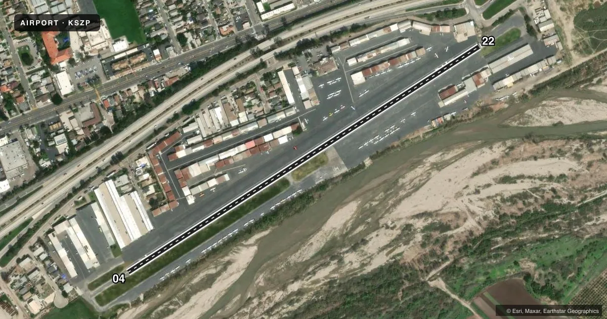
Runways & pattern
Full pagePattern entry · RWY 22
LEFT TRAFFICRunway end performance
| End | TORA | TODA | ASDA | LDA | VGSI | Approach lights | Obstruction |
|---|---|---|---|---|---|---|---|
| 04 | — | — | — | — | — | — | 16', bldg, 350' from thr, 95' R of cntrln, slope 9 |
| 22 | — | — | — | — | — | — | 16', trees, 200' from thr, 125' R of cntrln, slope 0 |
Declared distances in feet. TORA = takeoff run available, TODA = takeoff distance, ASDA = accelerate-stop, LDA = landing distance.
Airport sketch
Runways drawn to scale from FAA survey coordinates, rendered over satellite imagery. Not for navigation.
Approaches & charts
Services on the field
Fuel grades, oxygen, maintenance, ramp storage and lighting — as declared to the FAA by the airport operator.
Fuel & services
- Fuel
- 100LL
- Oxygen (bottled)
- Not available
- Oxygen (bulk)
- Not available
- Airframe repair
- Major
- Power plant repair
- Major
- Other services
- INSTR,RNTL,SALES,TOW
Ramp & ground
- Transient storage
- Tie-down
- Landing fee
- No fee published
- Customs
- Not available
- Wind indicator
- Yes
- Segmented circle
- Yes
Fuel & FBOs
Cheapest 100LL and Jet A on the field and nearby. Always confirm with the FBO before taxi.
Airport notes
Surface conditions, obstructions, local procedures, lighting outages and other notes published with each FAA cycle.
General notes
- NIGHT OPNS PROHIBITED.
- +4 FT SIGN IN PRMARY SFC AT NE END OF ARPT.
- ULTRALIGHTS; BANNER TOWING; GLIDERS; RC MODELS OPER IN THE VICINITY.
- DAILY AEROBATIC ACTIVITY 3-18 MILES EAST UP TO 5,255 FT AGL, MONITOR ON 122.775.
- BE ALERT TO WIRES CROSSING OVER RIVER BED ADJACENT TO RY 04/22. LOCATIONS: 1.5 MILES & 3.5 MILES SW APCH END RY 04. ALSO, 1,500 FT AND 2.5 MILES NE APCH END RY 22.
- HEL MUST USE DSGND HELI LCTD MID-FIELD ON THE SOUTH SIDE. ALL APCHS/DEPS ARE FROM THE SOUTH
- TSNT HEL RSRTD TO THE HELI. HOVER TAXI NOT AUTH.
- 2200 FT MT 1 NM S OF ARPT; FOR NOISE ABATEMENT MNTN 1500 FT UPWIND OVR CITY.
- NO OHD APCHS; NO 45 DEG ENTRIES; NO CROSSWIND ENTRIES OVR RWY.
- STAS NOT RCMDD.
- ENTER PAT FM EXTDD DOWNWIND LEG OR ENTER FM A CROSSWIND LEG AT LEAST 1 MI BYD THE DEP END OF ACTIVE RWY.
- FOR CD CTC LOS ANGELES ARTCC AT 661-575-2079.
Fuel notes
- 100LL24 HR SELF-FUELING AVBL WITH ALL MAJOR CREDIT CARDS.
Approach & departure obstructions
- 22RWY 22 APCH RATIO 20:1 TO DSPLCD THLD TREES & WIRES; APCH RATIO TO DSPLCD THLD 14:1 OVER +16 FT BLDG 220 FT FROM DSPLCD THLD 135 FT RIGHT.
Other notes
- ESTBD BEFORE 5/15/59.
- MANAGERSZPAIRPORT@GMAIL.COM
VFR map & nearby airports
VFR sectional. Tap any ICAO chip to open that airport.
Key facts · KSZP
Answer card- ICAO
- KSZP
- Name
- SANTA PAULA
- Location
- SANTA PAULA, CALIFORNIA
- Elevation
- 250 ft MSL
- Traffic pattern altitude
- 850 ft MSL (600 AGL)
- Control tower
- Non-towered (use CTAF)
- Total runways
- 1
- Longest runway
- 04/22 · 2,665 ft
- Published ILS approaches
- 0
- Published frequencies
- 1
- Magnetic variation
- 14°
- Current flight rules
- VFR
- Current wind
- 250° at 7 kt
- Favored runway now
- RWY 22
Santa Paula Airport (KSZP) is in Santa Paula, California. Field elevation is 250 ft MSL. The airport has one runway. Runway 04/22 is 2,665 ft of asphalt, so plan for a short-field mindset if you are bringing in a heavier aircraft. There is no control tower. CTAF is 122.9.
Pattern altitude is 600 ft AGL, which is 850 ft MSL. No ILS approaches are published. The field sits in a busy local training environment. Ultralights, banner towing, gliders and radio-controlled models operate nearby. Daily aerobatic activity also occurs east of the airport, so keep a sharp scan and monitor 122.775 for that traffic.
Santa Paula Airport, the on-field FBO, carries 100LL. Twenty-four hour self-fueling is available with major credit cards. Published remarks also call out restricted helicopter operations. Helicopters must use the designated mid-field area on the south side. All helicopter approaches and departures are from the south. Fixed-wing pilots should use the published pattern entry procedures. Enter from the extended downwind leg or from a crosswind leg at least 1 mile beyond the departure end of the active runway. Avoid overhead, 45-degree and crosswind entries over the runway. Night operations are prohibited. Runway 22 also has published obstacle and tree clearance concerns on approach, so review the current Chart Supplement before you go.