METAR & TAF KCMA
Current METAR
Observed 16:55Z
KCMA 261655Z 25007KT 8SM CLR 24/18 A2992 RMK AO2 SLP139 T02390183
- Wind
- 250° @ 7 kt
- Visibility
- 8 SM
- Temp / Dew
- 24°C / 18°C
- Altimeter
- 29.92 inHg
- Clouds
- CLR
- Density alt
- 1,175 ft
- Ceiling
- Unlimited
- Rules
- VFR
Airport info & contacts
Manager on record, flight service, ARTCC, attendance schedule and pattern altitude — published by the FAA and refreshed every 28 days.
Location
- From city
- 3 NM W
- VFR sectional
- LOS ANGELES
- Pattern altitude
- 800 ft AGL · 877 ft MSL
- ARTCC
- ZLA · LOS ANGELES
- NOTAM facility
- CMA (NOTAM-D)
Airport manager
- Name
- KEITH FREITAS
- Phone
- 805-388-4372
- Address
- 555 AIRPORT WAY, SUITE B, CAMARILLO CA 93010-8544
Flight service · Hours
- FSS HHR
- HAWTHORNE1-800-WX-BRIEF
- Attendance
- 0700-2300
Frequencies
Tap any row to copy the frequency to your clipboard.
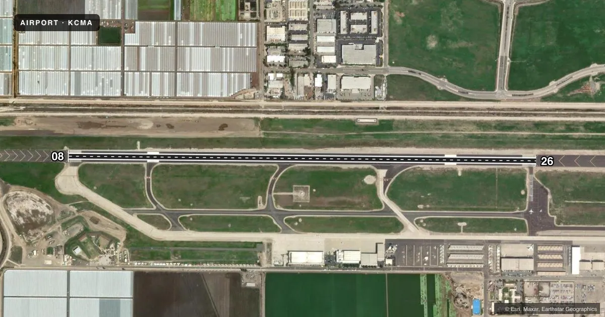
Runways & pattern
Full pagePattern entry · RWY 26
LEFT TRAFFICRunway end performance
| End | TORA | TODA | ASDA | LDA | VGSI | Approach lights | Obstruction |
|---|---|---|---|---|---|---|---|
| 08 | — | — | — | — | PAPI 4-box left(3°) | — | — |
| 26 | — | — | — | — | PAPI 4-box left(3°) | — | — |
Declared distances in feet. TORA = takeoff run available, TODA = takeoff distance, ASDA = accelerate-stop, LDA = landing distance.
Airport sketch
Runways drawn to scale from FAA survey coordinates, rendered over satellite imagery. Not for navigation.
Approaches & charts
Services on the field
Fuel grades, oxygen, maintenance, ramp storage and lighting — as declared to the FAA by the airport operator.
Fuel & services
- Fuel
- 100LLA
- Oxygen (bottled)
- Not available
- Oxygen (bulk)
- Low pressure
- Airframe repair
- Major
- Power plant repair
- Major
- Other services
- AVNCS,CHTR,INSTR,RNTL,SALES
Ramp & ground
- Transient storage
- Tie-down
- Landing fee
- Yes
- Customs
- Not available
- Lighting schedule
- SEE RMK
- Beacon schedule
- SS-SR
- Beacon
- White / Green (civil land)(WG)
- Wind indicator
- Lighted
- Segmented circle
- Yes
Fuel & FBOs
Cheapest 100LL and Jet A on the field and nearby. Always confirm with the FBO before taxi.
Airport notes
Surface conditions, obstructions, local procedures, lighting outages and other notes published with each FAA cycle.
General notes
- UNLGTD MTN 1173 FT MSL; BEGINNING 5 MILES FM EAST END RY 26. UNLGTD MTN 1814 FT MSL 5 MILES TO ESE OF APCH END RY 26.
- WILDLIFE ON AND INVOF ARPT.
- NO LDGS/TAXIING/TKOFS ON CHEVERONED AREA EAST OF RY 26 THR.
- NOISE: EXTREME NOISE SENSITIVE AREA.
- BE ALERT TO HIGH PERFORMANCE MIL ACFT OPNS INVOF ARPT.
- NO FORMATION TKOFS OR LDGS.
- HEL TRNG PADS TO THE N OF TWY B AND RY 8/26.
- UPON ARR CTC FBO OR ARPT OPS 805-947-6803 FOR ASSISTANCE.
- NOISE ORDINANCE CURFEW: ALL ACFT NO TKOFS BTN 0000 AND 0500 EXCP MIL, GOVT, MERCY FLTS & EMERG RESP.
- NOISE: AVOID OVERFLIGHT OF RESIDENTIAL COMMUNITIES EAST AND NORTH OF ARPT WHEN POSS.
- NOISE: ALL JET/TURBINE ACFT AVOID FLTS BTN 10PM AND 6AM LOCAL TO RDC NOISE OVER COMMUNITY.
- NOISE: ARR USE RWY 8, IF ABLE, WHEN ATCT CLSD.
- NOISE: FLY FRIENDLY PROCEDURES IN EFFECT. VISIT VENTURA COUNTY AIRPORTS WEBSITE FOR DETAILS.
- WT RSTRD TO ACFT WITH MAX TKOF WT BLW 115OOO LBS DUAL WHEEL GEAR.
Lighting notes
- WHEN ATCT CLSD ACTVT MIRL RY 08/26, REIL RYS 08 AND 26 AND PAPI RYS 8 AND 26 - CTAF.
- ULTRALIGHT ACTIVITY SW QUAD OF ARPT.
Fuel notes
- 100LLFUEL AVBL 24 HRS SELF SERVE.
Other notes
- <LNDG FEE FOR ACFT OVER 12,500 LBS.
- TPA SINGLE ENGINE 800 FT AGL; MULTI ENGINE AND JETS 1000 FT AGL.
- MANAGERKEITH.FREITAS@VENTURA.ORG
VFR map & nearby airports
VFR sectional. Tap any ICAO chip to open that airport.
Key facts · KCMA
Answer card- ICAO
- KCMA
- Name
- CAMARILLO
- Location
- CAMARILLO, CALIFORNIA
- Elevation
- 76.8 ft MSL
- Traffic pattern altitude
- 876.8 ft MSL (800 AGL)
- Control tower
- Towered · 0700-2100
- Total runways
- 1
- Longest runway
- 08/26 · 6,013 ft
- Published ILS approaches
- 0
- Published frequencies
- 12
- Magnetic variation
- 14°
- Current flight rules
- VFR
- Current wind
- 250° at 7 kt
- Favored runway now
- RWY 26
Camarillo Airport is in Camarillo, California. The field elevation is 76.8 ft MSL. It has one runway, 08/26, which is 6,013 ft long. The control tower is open 0700-2100. No ILS approaches are published here.
The traffic pattern altitude is 800 ft AGL, which is 876.8 ft MSL. That is the number to brief, not a recomputed value. The airport sits in a busy part of Ventura County. Expect local traffic and be ready for high performance military aircraft in the area. Fly friendly procedures are in effect. Avoid overflight of residential communities east and north of the airport when possible.
Three on-field FBOs are listed. Sun Air Jets, Channel Islands Aviation and AIR 7 all carry 100LL, Jet A and Jet A Prist. If you need current ramp help or arrival coordination, the published remarks say to contact the FBO or airport operations at 805-947-6803. When the tower is closed, runway lights on 08/26 can be activated on CTAF. The published remarks also note a noise curfew. No aircraft may take off between 0000 and 0500 except military, government, mercy flights and emergency response. Jet and turbine aircraft must also avoid flights between 2200 and 0600 local time.