METAR & TAF KIZA
Current METAR
Observed 23:55Z
KIZA 252355Z AUTO 26011KT 10SM CLR 30/13 A2990 RMK AO2
- Wind
- 260° @ 11 kt
- Visibility
- 10 SM
- Temp / Dew
- 30°C / 13°C
- Altimeter
- 29.90 inHg
- Clouds
- CLR
- Density alt
- 2,661 ft
- Ceiling
- Unlimited
- Rules
- VFR
Airport info & contacts
Manager on record, flight service, ARTCC, attendance schedule and pattern altitude — published by the FAA and refreshed every 28 days.
Location
- From city
- 1 NM SE
- VFR sectional
- LOS ANGELES
- ARTCC
- ZLA · LOS ANGELES
- NOTAM facility
- IZA (NOTAM-D)
Airport manager
- Name
- DAVE ROMERO
- Phone
- 805-688-8390
- Address
- 900 AIRPORT ROAD, P.O. BOX 1572, SANTA YNEZ CA 93460
Flight service · Hours
- FSS HHR
- HAWTHORNE1-800-WX-BRIEF
- Attendance
- 0700-1900
Frequencies
Tap any row to copy the frequency to your clipboard.
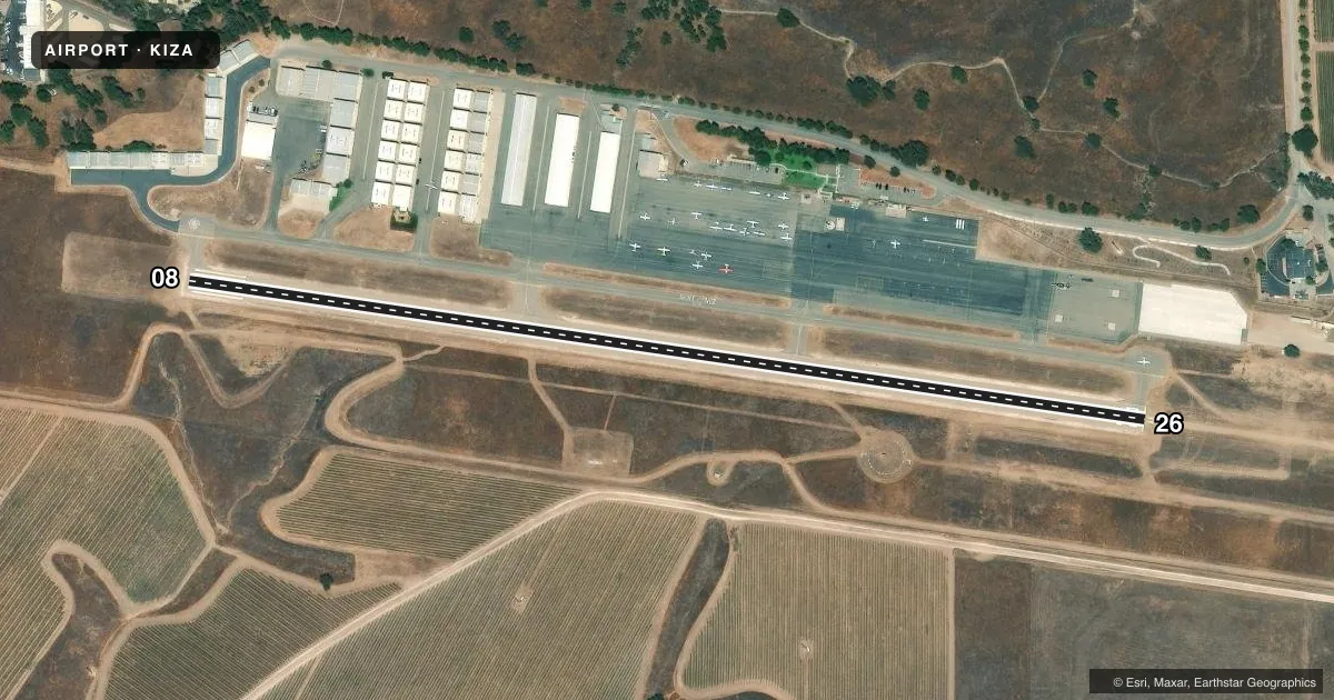
Runways & pattern
Full pagePattern entry · RWY 26
LEFT TRAFFICRunway end performance
| End | TORA | TODA | ASDA | LDA | VGSI | Approach lights | Obstruction |
|---|---|---|---|---|---|---|---|
| 08 | — | — | — | — | PAPI 2-box left(3°) | — | 17', hill, 750' from thr, 150' R of cntrln, slope 32 |
| 26 | — | — | — | — | PAPI 2-box left(3°) | — | — |
Declared distances in feet. TORA = takeoff run available, TODA = takeoff distance, ASDA = accelerate-stop, LDA = landing distance.
Airport sketch
Runways drawn to scale from FAA survey coordinates, rendered over satellite imagery. Not for navigation.
Approaches & charts
Services on the field
Fuel grades, oxygen, maintenance, ramp storage and lighting — as declared to the FAA by the airport operator.
Fuel & services
- Fuel
- 100LLA
- Oxygen (bottled)
- Not available
- Oxygen (bulk)
- Not available
- Airframe repair
- Not available
- Power plant repair
- Not available
- Other services
- CHTR,GLD,INSTR,RNTL,TOW
Ramp & ground
- Transient storage
- Tie-down
- Landing fee
- No fee published
- Customs
- Not available
- Lighting schedule
- SEE RMK
- Beacon schedule
- SS-SR
- Beacon
- White / Green (civil land)(WG)
- Wind indicator
- Lighted
- Segmented circle
- Yes
Fuel & FBOs
Cheapest 100LL and Jet A on the field and nearby. Always confirm with the FBO before taxi.
Airport notes
Surface conditions, obstructions, local procedures, lighting outages and other notes published with each FAA cycle.
General notes
- RWY 26 TKOF RCMD HDG 210 DEG AT ARPT PERIMETER IF SAFETY PMT FOR NOISE ABATEMENT.
- GLIDER OPNS ON DIRT APCH ZONE RWY 26; GLIDERS OPERG RIGHT TFC RWY 26.
- ULTRALIGHT OPNS SOUTH OF RWY 08/26.
- HELICOPTERS APCH FROM NORTH & SOUTH ON EAST END OF ARPT
- FOR CD CTC LOS ANGELES ARTCC AT 661-575-2079.
Lighting notes
- MIRL RWY 08/26 PRESET LOW INTST; TO INCR INTST & ACTVT REIL RWY 08 & 26; TWY LGTS - CTAF. PAPI RWY 08 & 26 OPR CONSLY.
Fuel notes
- 100LLFUEL AVBL 24 HRS USING AUTOMATED SYSTEM.
VFR map & nearby airports
VFR sectional. Tap any ICAO chip to open that airport.
Key facts · KIZA
Answer card- ICAO
- KIZA
- Name
- SANTA YNEZ/KUNKLE FLD
- Location
- SANTA YNEZ, CALIFORNIA
- Elevation
- 674.3 ft MSL
- Traffic pattern altitude
- 1,674.3 ft MSL (1,000 AGL)
- Control tower
- Non-towered (use CTAF)
- Total runways
- 1
- Longest runway
- 08/26 · 2,803 ft
- Published ILS approaches
- 0
- Published frequencies
- 4
- Magnetic variation
- 14°
- Current flight rules
- VFR
- Current wind
- 260° at 11 kt
- Favored runway now
- RWY 26
Santa Ynez/Kunkle Fld sits in Santa Ynez, California. Field elevation is 674.3 ft MSL. The airport has one runway. Runway 08/26 is 2,803 ft long with asphalt pavement. There is no control tower. Pattern altitude is not published, so use the standard 1,000 ft AGL for light piston traffic unless the current Chart Supplement says otherwise.
There are no published ILS approaches here. The field is served by Santa Barbara approach and departure frequencies. CTAF and UNICOM are both 122.8. The on-field FBO is Santa Ynez Airport. It carries 100LL, JET A and JET A Prist. Fuel is available 24 hours through an automated system.
A few local items matter on a first visit. Glider operations occur in the dirt approach zone for runway 26. Gliders use right traffic for runway 26. Ultralight operations are south of runway 08/26. Runway 26 has a recommended takeoff heading of 210 degrees at the airport perimeter if safety permits for noise abatement. Medium intensity runway lights are preset to low intensity. Use CTAF to increase intensity and to activate runway end identifier lights on runways 08 and 26. Precision approach path indicators on both ends operate continuously. Helicopters approach from the north and south on the east end of the airport.