METAR & TAF KLPC
Current METAR
Observed 16:51Z
KLPC 261651Z AUTO VRB05KT 10SM OVC006 16/16 A3002 RMK AO2 SLP166 T01560156
- Wind
- VAR @ 5 kt
- Visibility
- 10 SM
- Temp / Dew
- 16°C / 16°C
- Altimeter
- 30.02 inHg
- Clouds
- OVC
- Density alt
- 105 ft
- Ceiling
- 600 ft AGL
- Rules
- IFR
Airport info & contacts
Manager on record, flight service, ARTCC, attendance schedule and pattern altitude — published by the FAA and refreshed every 28 days.
Location
- From city
- 2 NM N
- VFR sectional
- LOS ANGELES
- Pattern altitude
- 813 ft AGL · 901 ft MSL
- ARTCC
- ZLA · LOS ANGELES
- NOTAM facility
- LPC (NOTAM-D)
Airport manager
- Name
- RICHARD FERNBAUGH
- Phone
- 805-875-8268
- Address
- CITY OF LOMPOC, 100 CIVIC CENTER PLAZA, LOMPOC CA 93436-8001
Flight service · Hours
- FSS HHR
- HAWTHORNE1-800-WX-BRIEF
- Attendance
- 0800-1700
Frequencies
Tap any row to copy the frequency to your clipboard.
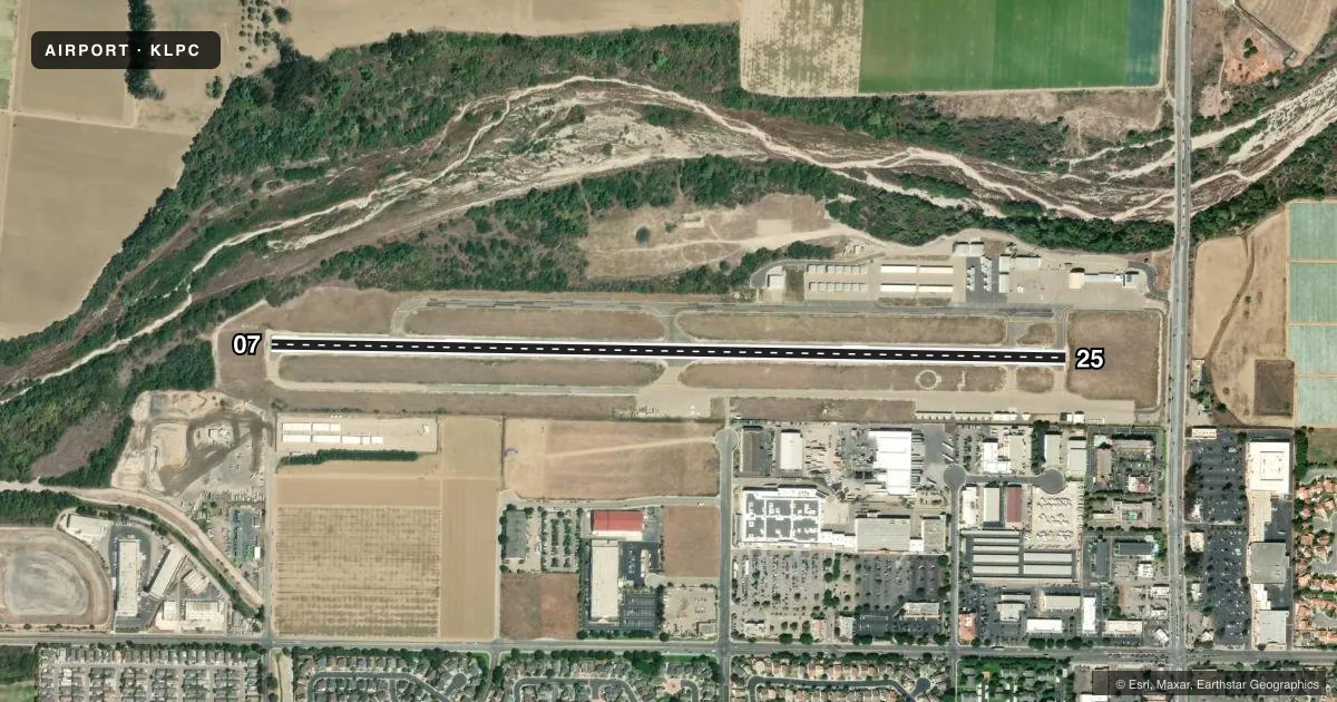
Runways & pattern
Full pagePattern entry · RWY 25
RIGHT TRAFFICRunway end performance
| End | TORA | TODA | ASDA | LDA | VGSI | Approach lights | Obstruction |
|---|---|---|---|---|---|---|---|
| 07 | — | — | — | — | — | — | 25', brush, 720' from thr, 0' R of cntrln, slope 20 |
| 25 | — | — | — | — | PAPI 4-box left(3.25°) | — | 25', pline, 1050' from thr, 0' R of cntrln, slope 34 |
Declared distances in feet. TORA = takeoff run available, TODA = takeoff distance, ASDA = accelerate-stop, LDA = landing distance.
Airport sketch
Runways drawn to scale from FAA survey coordinates, rendered over satellite imagery. Not for navigation.
Approaches & charts
Services on the field
Fuel grades, oxygen, maintenance, ramp storage and lighting — as declared to the FAA by the airport operator.
Fuel & services
- Fuel
- 100LLA
- Oxygen (bottled)
- High pressure
- Oxygen (bulk)
- High pressure
- Airframe repair
- Major
- Power plant repair
- Major
- Other services
- AGRI,INSTR,RNTL
Ramp & ground
- Transient storage
- Tie-down
- Landing fee
- No fee published
- Customs
- Not available
- Lighting schedule
- SEE RMK
- Beacon schedule
- SS-SR
- Beacon
- White / Green (civil land)(WG)
- Wind indicator
- Lighted
- Segmented circle
- Yes
Fuel & FBOs
Cheapest 100LL and Jet A on the field and nearby. Always confirm with the FBO before taxi.
Airport notes
Surface conditions, obstructions, local procedures, lighting outages and other notes published with each FAA cycle.
General notes
- DEER ON & INVOF ARPT.
- ULTRALIGHT AND SKYDIVING ACT IN VCNTY OF ARPT DALGT HRS MON-SUN. XNG MID-FLD DUR SKYDIVING OPS NOT ADZD.
- FOR CD CTC LOS ANGELES ARTCC AT 661-575-2079.
Lighting notes
- ACTVT REIL RWY 25; MIRL RWY 07/25 - CTAF. PAPI RWY 25 ON CONSLY.
Fuel notes
- 100LLFUEL AVBL 24 HRS; SELF-SERVICE CREDIT CARD ONLY.
VFR map & nearby airports
VFR sectional. Tap any ICAO chip to open that airport.
Key facts · KLPC
Answer card- ICAO
- KLPC
- Name
- LOMPOC
- Location
- LOMPOC, CALIFORNIA
- Elevation
- 88.1 ft MSL
- Traffic pattern altitude
- 901.1 ft MSL (813 AGL)
- Control tower
- Non-towered (use CTAF)
- Total runways
- 1
- Longest runway
- 07/25 · 4,600 ft
- Published ILS approaches
- 0
- Published frequencies
- 4
- Magnetic variation
- 15°
- Current flight rules
- IFR
- Current wind
- 000° at 5 kt
- Favored runway now
- RWY 25
Lompoc Airport sits in Lompoc, California. Field elevation is 88.1 ft MSL. The airport has one runway, 07/25, which is 4,600 ft long. There is no control tower. Pattern altitude is 813 ft AGL, which is 901.1 ft MSL.
No ILS approaches are published here. For clearance delivery, contact Los Angeles ARTCC at 661-575-2079. The field uses CTAF 122.7 for local traffic. The published approach frequencies are handled by Santa Barbara.
Lompoc Airport has one on-field FBO. Lompoc Airport carries 100LL and Jet A. Fuel is available 24 hours. Self-service is credit card only. Runway 25 has runway end identifier lights. Medium intensity runway lights on 07 and 25 are controlled by CTAF. The PAPI on runway 25 is on continuously.
A first-time pilot should pay attention to the local traffic picture. Ultralight and skydiving activity occur near the airport daily. Crossing midfield during skydiving operations is not advised. Deer are also on and near the airport. That makes a good lookout important on taxi, takeoff and landing. The runway is long enough for normal GA use. The field still calls for standard discipline on the radio and a careful scan outside.