METAR & TAF F34
F34 does not publish a METAR.
Showing the nearest reporting station: KMAE (MADERA MUNI) · 18.6 NM away. Conditions at F34 may differ.
METAR · KMAE
Observed 12:55Z
KMAE 271255Z AUTO 31004KT 10SM CLR 14/10 A2995 RMK AO2 SLP137 T01440100 $
- Wind
- 310° @ 4 kt
- Visibility
- 10 SM
- Temp / Dew
- 14°C / 10°C
- Altimeter
- 29.95 inHg
- Clouds
- CLR
- Density alt
- 38 ft
- Ceiling
- Unlimited
- Rules
- VFR
Airport info & contacts
Manager on record, flight service, ARTCC, attendance schedule and pattern altitude — published by the FAA and refreshed every 28 days.
Location
- From city
- 1 NM W
- VFR sectional
- SAN FRANCISCO
- Pattern altitude
- 850 ft AGL · 1,007 ft MSL
- ARTCC
- ZOA · OAKLAND
- NOTAM facility
- RIU (NOTAM-D)
Airport manager
- Name
- BEN GALLEGOS
- Phone
- 559-659-2043
- Address
- 1133 P STREET, FIREBAUGH CA 93622
Flight service · Hours
- FSS RIU
- RANCHO MURIETA1-800-WX-BRIEF
- Attendance
- Unattended
Frequencies
Tap any row to copy the frequency to your clipboard.
Runways & pattern
Full pagePattern entry · RWY 30
LEFT TRAFFICRunway end performance
| End | TORA | TODA | ASDA | LDA | VGSI | Approach lights | Obstruction |
|---|---|---|---|---|---|---|---|
| 12 | — | — | — | — | — | — | 10', road, 400' from thr, 0' R of cntrln, slope 20 |
| 30 | — | — | — | — | VASI 2-box left(3°) | — | 15', road, 700' from thr, 0' R of cntrln, slope 33 |
Declared distances in feet. TORA = takeoff run available, TODA = takeoff distance, ASDA = accelerate-stop, LDA = landing distance.
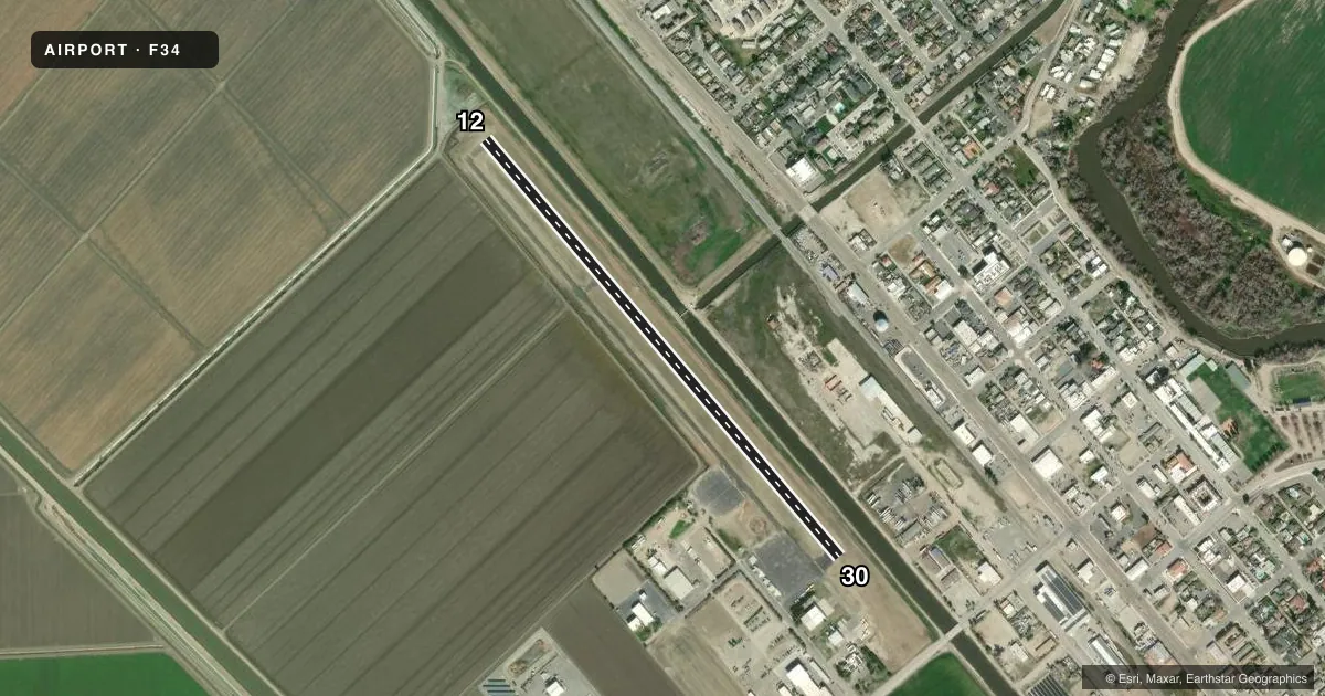
Airport sketch
Runways drawn to scale from FAA survey coordinates, rendered over satellite imagery. Not for navigation.
Approaches & charts
Services on the field
Fuel grades, oxygen, maintenance, ramp storage and lighting — as declared to the FAA by the airport operator.
Fuel & services
- Fuel
- Not available
- Oxygen (bottled)
- Not available
- Oxygen (bulk)
- Not available
- Airframe repair
- Not available
- Power plant repair
- Not available
- Other services
- AGRI
Ramp & ground
- Transient storage
- Tie-down
- Landing fee
- No fee published
- Customs
- Not available
- Lighting schedule
- SEE RMK
- Beacon schedule
- SS-SR
- Beacon
- White / Green (civil land)(WG)
- Wind indicator
- Lighted
- Segmented circle
- Yes
Fuel & FBOs
Cheapest 100LL and Jet A on the field and nearby. Always confirm with the FBO before taxi.
Airport notes
Surface conditions, obstructions, local procedures, lighting outages and other notes published with each FAA cycle.
General notes
- FOR CD CTC NORCAL APCH AT 916-361-6874.
- RWY SAFETY AREA 140 FT BYD RWY 30 END.
Lighting notes
- ACTVT MIRL RY 12/30 AND VASI RY 30 - CTAF.
Approach & departure obstructions
- 12RWY 12 +2' BERM, 6' FENCE & 5' DITCH 80'-140' FM RWY END 125'L TO 125'R.
Other notes
- MANAGERCITY MGR. MAINTENANCE CONTACT PUBLIC WORKS, BEN GALLEGOS 559-659-2043
VFR map & nearby airports
VFR sectional. Tap any ICAO chip to open that airport.
Key facts · F34
Answer card- ICAO
- F34
- Name
- FIREBAUGH
- Location
- FIREBAUGH, CALIFORNIA
- Elevation
- 157.2 ft MSL
- Traffic pattern altitude
- 1,007.2 ft MSL (850 AGL)
- Control tower
- Non-towered (use CTAF)
- Total runways
- 1
- Longest runway
- 12/30 · 3,102 ft
- Published ILS approaches
- 0
- Published frequencies
- 3
- Magnetic variation
- 16°
- Current flight rules
- VFR
- Current wind
- 310° at 4 kt
- Favored runway now
- RWY 30
Firebaugh Airport sits in Firebaugh, California. Field elevation is 157.2 ft MSL. The airport has one runway. Runway 12/30 is 3,102 ft long on asphalt. There is no control tower. Pattern altitude is 850 ft AGL, which is 1,007.2 ft MSL.
No ILS approaches are published here. For clearance delivery, contact NorCal Approach at 916-361-6874. CTAF is 122.9. NorCal Approach frequencies listed for the field are 120.95 and 269.45. The runway lights are medium intensity. The visual approach slope indicator on runway 30 is activated by CTAF.
There are no on-field FBOs listed, so plan on verifying services before you go. Check with the airport operator or the FBO directly by phone for current fuel availability and ramp details. Published remarks also note a berm, fence and ditch near runway 12. That makes the departure end worth a close look during your preflight and landing planning. The runway safety area also extends 140 feet beyond the runway 30 end. For a first visit, treat this as a small non-towered field with limited published approach support. Use the current Chart Supplement for any noise or operating notes before you launch.