METAR & TAF 2O6
2O6 does not publish a METAR.
Showing the nearest reporting station: KMAE (MADERA MUNI) · 9.9 NM away. Conditions at 2O6 may differ.
METAR · KMAE
Observed 07:55Z
KMAE 270755Z AUTO 28008KT 10SM CLR 20/13 A2995 RMK AO2 SLP136 T02000128 $
- Wind
- 280° @ 8 kt
- Visibility
- 10 SM
- Temp / Dew
- 20°C / 13°C
- Altimeter
- 29.95 inHg
- Clouds
- CLR
- Density alt
- 864 ft
- Ceiling
- Unlimited
- Rules
- VFR
Airport info & contacts
Manager on record, flight service, ARTCC, attendance schedule and pattern altitude — published by the FAA and refreshed every 28 days.
Location
- From city
- 1 NM SE
- VFR sectional
- SAN FRANCISCO
- ARTCC
- ZOA · OAKLAND
- NOTAM facility
- RIU (NOTAM-D)
Airport manager
- Name
- JASON ROGERS
- Phone
- (559) 267-3157
- Address
- 130 SOUTH 2ND STREET, CHOWCHILLA CA 93610
Flight service · Hours
- FSS RIU
- RANCHO MURIETA1-800-WX-BRIEF
- Attendance
- Unattended
Frequencies
Tap any row to copy the frequency to your clipboard.
Runways & pattern
Full pagePattern entry · RWY 30
RIGHT TRAFFICRunway end performance
| End | TORA | TODA | ASDA | LDA | VGSI | Approach lights | Obstruction |
|---|---|---|---|---|---|---|---|
| 12 | — | — | — | — | — | — | 60', ant, 1500' from thr, 100' R of cntrln, slope 21 |
| 30 | — | — | — | — | — | — | 50', tower, 500' from thr, 300' R of cntrln, slope 6 |
Declared distances in feet. TORA = takeoff run available, TODA = takeoff distance, ASDA = accelerate-stop, LDA = landing distance.
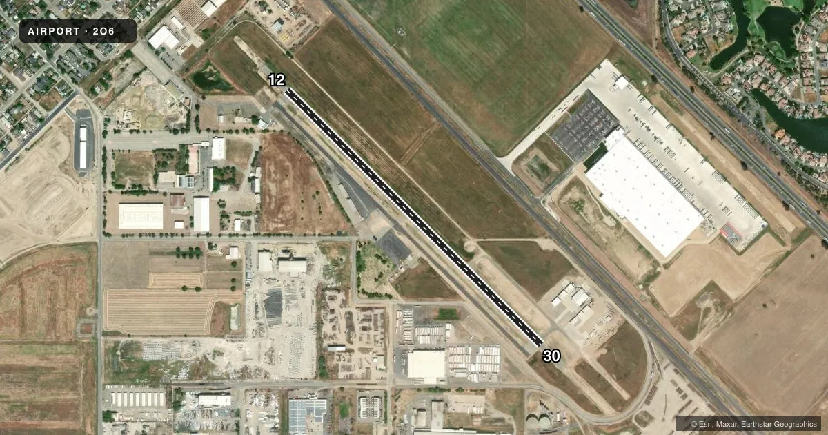
Airport sketch
Runways drawn to scale from FAA survey coordinates, rendered over satellite imagery. Not for navigation.
Approaches & charts
Services on the field
Fuel grades, oxygen, maintenance, ramp storage and lighting — as declared to the FAA by the airport operator.
Fuel & services
- Fuel
- Not available
- Oxygen (bottled)
- Not available
- Oxygen (bulk)
- Not available
- Other services
- AGRI
Ramp & ground
- Transient storage
- Tie-down
- Landing fee
- No fee published
- Customs
- Not available
- Lighting schedule
- SEE RMK
- Wind indicator
- Lighted
- Segmented circle
- Yes
Fuel & FBOs
Cheapest 100LL and Jet A on the field and nearby. Always confirm with the FBO before taxi.
Airport notes
Surface conditions, obstructions, local procedures, lighting outages and other notes published with each FAA cycle.
General notes
- APCH TO RWY 12 +35' POWERLINES 1150' FM THR ON EXTNDD RY CNTRLN.
- FOR CD CTC NORCAL APCH AT 916-361-0516.
Lighting notes
- ACTVT MIRL RY 12/30 - CTAF.
Runway surface & condition
- 12/30300 FT STOPWAYS AT BOTH ENDS OF RY.
Approach & departure obstructions
- 1250 FT TOWER 300 FT LEFT OF RWY 30 CNTRLN.
Other notes
- MANAGEREXT 300
VFR map & nearby airports
VFR sectional. Tap any ICAO chip to open that airport.
Key facts · 2O6
Answer card- ICAO
- 2O6
- Name
- CHOWCHILLA
- Location
- CHOWCHILLA, CALIFORNIA
- Elevation
- 243 ft MSL
- Traffic pattern altitude
- 1,243 ft MSL (1,000 AGL)
- Control tower
- Non-towered (use CTAF)
- Total runways
- 1
- Longest runway
- 12/30 · 3,253 ft
- Published ILS approaches
- 0
- Published frequencies
- 1
- Magnetic variation
- 15°
- Current flight rules
- VFR
- Current wind
- 280° at 8 kt
- Favored runway now
- RWY 30
Chowchilla Airport sits in Chowchilla, California at 243 ft MSL. It has one runway, 12/30, which is 3,253 ft long and asphalt. The field is not towered. CTAF is 122.9. No ILS approaches are published here.
The pattern altitude is not published. Use the standard 1,000 ft AGL pattern for light piston aircraft unless the current Chart Supplement or local procedure says otherwise. Runway 12/30 has medium intensity lighting that is activated by CTAF. There are 300-foot stopways at both ends of the runway. For clearance delivery, contact NorCal Approach at 916-361-0516.
There are a few items a first-time pilot should have in mind. A 50-foot tower sits 300 feet left of the runway 30 centerline. Runway 12 has 35-foot powerlines 1,150 feet from the threshold on the extended centerline. There are no on-field FBOs listed, so verify services with the airport operator or call ahead before you go. If you need current noise, curfew, or operational details, check the current FAA Chart Supplement before flying in.