METAR & TAF KHJO
Current METAR
Observed 10:53Z
KHJO 271053Z AUTO 33009KT 10SM CLR 22/09 A2993 RMK AO2 SLP133 T02170089
- Wind
- 330° @ 9 kt
- Visibility
- 10 SM
- Temp / Dew
- 22°C / 9°C
- Altimeter
- 29.93 inHg
- Clouds
- CLR
- Density alt
- 1,125 ft
- Ceiling
- Unlimited
- Rules
- VFR
Airport info & contacts
Manager on record, flight service, ARTCC, attendance schedule and pattern altitude — published by the FAA and refreshed every 28 days.
Location
- From city
- 1 NM SE
- VFR sectional
- SAN FRANCISCO
- ARTCC
- ZOA · OAKLAND
- NOTAM facility
- HJO (NOTAM-D)
Airport manager
- Name
- BOB LOOGMAN
- Phone
- 559-585-2589
- Address
- 900 SOUTH 10TH AVENUE, HANFORD CA 93230
Flight service · Hours
- FSS RIU
- RANCHO MURIETA1-800-WX-BRIEF
- Attendance
- 0800-1700
Frequencies
Tap any row to copy the frequency to your clipboard.
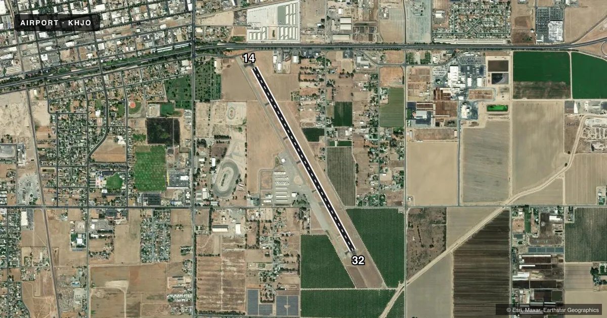
Runways & pattern
Full pagePattern entry · RWY 32
RIGHT TRAFFICRunway end performance
| End | TORA | TODA | ASDA | LDA | VGSI | Approach lights | Obstruction |
|---|---|---|---|---|---|---|---|
| 14 | — | — | — | — | PAPI 4-box right(4°) | — | 17', road, 245' from thr, 0' R of cntrln, slope 2 |
| 32 | — | — | — | — | PAPI 4-box left(3°) | — | — |
Declared distances in feet. TORA = takeoff run available, TODA = takeoff distance, ASDA = accelerate-stop, LDA = landing distance.
Airport sketch
Runways drawn to scale from FAA survey coordinates, rendered over satellite imagery. Not for navigation.
Approaches & charts
Services on the field
Fuel grades, oxygen, maintenance, ramp storage and lighting — as declared to the FAA by the airport operator.
Fuel & services
- Fuel
- 100LL
- Oxygen (bottled)
- HIGH/LOW
- Oxygen (bulk)
- Not available
- Airframe repair
- Major
- Power plant repair
- Minor
- Other services
- CHTR,INSTR,SALES
Ramp & ground
- Transient storage
- Tie-down
- Landing fee
- No fee published
- Customs
- Not available
- Lighting schedule
- SEE RMK
- Beacon schedule
- SS-SR
- Beacon
- White / Green (civil land)(WG)
- Wind indicator
- Lighted
- Segmented circle
- Yes
Fuel & FBOs
Cheapest 100LL and Jet A on the field and nearby. Always confirm with the FBO before taxi.
Airport notes
Surface conditions, obstructions, local procedures, lighting outages and other notes published with each FAA cycle.
General notes
- FOR CD CTC FRESNO APCH AT 559-454-9805.
Lighting notes
- AFTER DARK ACTVT REIL RWY 32; MIRL RWY 14/32 - CTAF.
Fuel notes
- 100LLFUEL SELF-SERVICE AVBL 24 HRS.
Approach & departure obstructions
- 32PAPI RY 32 UNUSBL BYD 2 NM.
VFR map & nearby airports
VFR sectional. Tap any ICAO chip to open that airport.
Key facts · KHJO
Answer card- ICAO
- KHJO
- Name
- HANFORD MUNI
- Location
- HANFORD, CALIFORNIA
- Elevation
- 239.5 ft MSL
- Traffic pattern altitude
- 1,239.5 ft MSL (1,000 AGL)
- Control tower
- Non-towered (use CTAF)
- Total runways
- 1
- Longest runway
- 14/32 · 5,179 ft
- Published ILS approaches
- 0
- Published frequencies
- 4
- Magnetic variation
- 14°
- Current flight rules
- VFR
- Current wind
- 330° at 9 kt
- Favored runway now
- RWY 32
Hanford Muni is in Hanford, California. The field elevation is 239.5 ft MSL. It has one runway, 14/32, which is 5,179 ft long and asphalt. There is no control tower. Clearance delivery is handled through Fresno Approach. The published frequency is 123.9. No ILS approaches are published here.
Pattern altitude is not published. Use the standard 1,000 ft AGL pattern unless the current Chart Supplement says otherwise. That puts the light piston pattern at about 1,240 ft MSL based on the field elevation, but verify the current published pattern before you fly. The runway headings are magnetic. Runway 14 is 151°. Runway 32 is 331°.
There are no on-field FBOs listed in the facts. Self-service 100LL is available 24 hours. After dark, runway 32 REIL and the medium intensity runway lights on runways 14 and 32 are activated by CTAF. One operational note matters here. The PAPI for runway 32 is unusable beyond 2 NM. If you are planning a night arrival or a first visit, brief the lighting setup and confirm your approach path early. This is a non-towered field in the Central Valley, so keep your radio work tight and verify current procedures with the FAA Chart Supplement before departure.