METAR & TAF KFAT
Current METAR
Observed 11:53Z
KFAT 271153Z 32008KT 10SM CLR 21/08 A2993 RMK AO2 SLP129 T02110078 10283 20211 51001 $
- Wind
- 320° @ 8 kt
- Visibility
- 10 SM
- Temp / Dew
- 21°C / 8°C
- Altimeter
- 29.93 inHg
- Clouds
- CLR
- Density alt
- 1,124 ft
- Ceiling
- Unlimited
- Rules
- VFR
Airport info & contacts
Manager on record, flight service, ARTCC, attendance schedule and pattern altitude — published by the FAA and refreshed every 28 days.
Location
- From city
- 5 NM NE
- VFR sectional
- SAN FRANCISCO
- Pattern altitude
- 967 ft AGL · 1,303 ft MSL
- ARTCC
- ZOA · OAKLAND
- NOTAM facility
- FAT (NOTAM-D)
Airport manager
- Name
- FRANCISCO PARTIDA
- Phone
- 559-621-4531
- Address
- 4995 E CLINTON WAY, FRESNO CA 93722
Flight service · Hours
- FSS RIU
- RANCHO MURIETA1-800-WX-BRIEF
- Attendance
- ALL
Frequencies
Tap any row to copy the frequency to your clipboard.
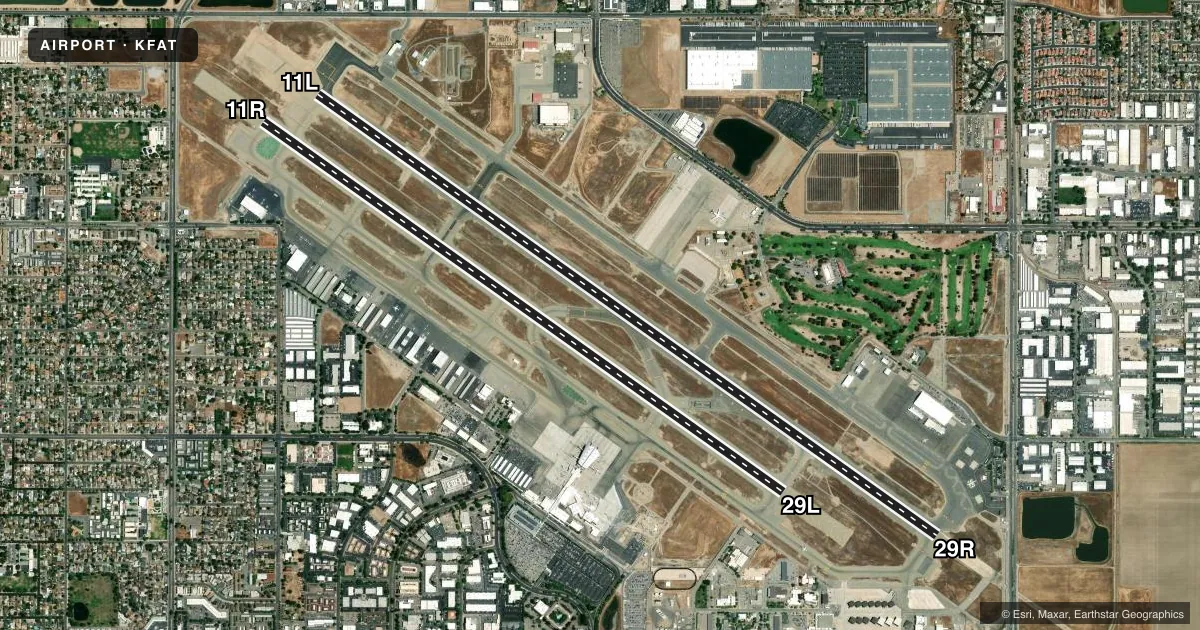
Runways & pattern
Full pagePattern entry · RWY 29R
RIGHT TRAFFIC| Runway | Heading (°M) | Length | Surface | Traffic |
|---|---|---|---|---|
| 11L/29RFavored | 112° / 292° | 9,539 ft | ASPH | 29R R |
| 11R/29L | 112° / 292° | 8,008 ft | ASPH | 11R R |
Runway end performance
| End | TORA | TODA | ASDA | LDA | VGSI | Approach lights | Obstruction |
|---|---|---|---|---|---|---|---|
| 11L | 9,539' | 9,539' | 9,279' | 9,279' | PAPI 4-box left(3°) | — | 67', tree, 755' from thr, 780' R of cntrln, slope 8 |
| 29R | 9,539' | 9,539' | 9,539' | 9,227' | PAPI 4-box left(3°) | ALSF2 | 16', road, 750' from thr, 580' R of cntrln, slope 34 |
| 11R | 8,008' | 8,008' | 8,008' | 8,008' | — | — | — |
| 29L | 8,008' | 8,008' | 8,008' | 8,008' | PAPI 4-box left(3°) | — | — |
Declared distances in feet. TORA = takeoff run available, TODA = takeoff distance, ASDA = accelerate-stop, LDA = landing distance.
Airport sketch
Runways drawn to scale from FAA survey coordinates, rendered over satellite imagery. Not for navigation.
Approaches & charts
ILS · 2
Services on the field
Fuel grades, oxygen, maintenance, ramp storage and lighting — as declared to the FAA by the airport operator.
Fuel & services
- Fuel
- 100AA++
- Oxygen (bottled)
- HIGH/LOW
- Oxygen (bulk)
- High pressure
- Airframe repair
- Major
- Power plant repair
- Major
- Other services
- AFRT,AVNCS,CARGO,CHTR,INSTR,RNTL,SALES,SURV
Ramp & ground
- Transient storage
- Tie-down
- Hangar
- Landing fee
- No fee published
- Customs
- Not available
- Beacon schedule
- SS-SR
- Beacon
- White / Green (civil land)(WG)
- Wind indicator
- Lighted
- Segmented circle
- Yes
Fuel & FBOs
Cheapest 100LL and Jet A on the field and nearby. Always confirm with the FBO before taxi.
Airport notes
Surface conditions, obstructions, local procedures, lighting outages and other notes published with each FAA cycle.
General notes
- FRESNO YOSEMITE INTL IS NOISE SENSITIVE; NOISE ABATEMENT PROCEDURES IN EFFECT.
- NO MULT APCHS AND LNDGS MON-SAT 2200-0700 AND SUN 1800-1000.
- POSSIBLE WAKE TURBULENCE OR WIND SHEAR ARR TO RY 29L OR DEP FM RY 11R. JET TESTING CONDUCTED AT AIR NATIONAL GUARD RAMP LCTD AT SE CORNER OF ARPT.
- NUMEROUS BIRDS INVOF ARPT.
- LGTD RY DISTANCE REMAINING MARKERS ON SOUTH SIDE OF RY 11R/29L; LGTD RY DISTANCE REMAINING MARKERS BOTH SIDES OF RY 11L/29R- 11L DRM ON NORTH SIDE; 29R DRM ON SOUTH SIDE.
- RETRACTABLE BAK-12/14 AVBL ON RWY 11L AND RWY 29R ARE KEPT IN RECESSED PSN UNTIL REQ FOR USE; TWR MUST BE NTFD AT LEAST 5 SECS PRIOR TO ENGAGEMENT SO THAT THE A-GEAR CABLE MAY BE RAISED. MB-100 ARST CABLE INSTLD AT RWY 11R BLAST PAD FOR RWY 29L DEPS ONLY.
- MILITARY: ANG: CTC ANG OPS FOR LCL BIRD WATCH COND (BWC).
- MILITARY: SVC: RWY 29R AND 11L A-GEAR CABLE AVBL UPON REQ ONLY; DEFAULT POSN DOWN.
- TWY B3 CLSD BTN RWY 11L/29R AND RWY 11R/29L.
- TWY A LTD TO ACFT DESIGN GROUP II.
- ATCT CLNC RQRD TO PUSH ON MOV AREA.
- PPR FOR ENG START AT ACR TRML GATES & ENG RUN-UP.
Runway surface & condition
- 11L/29RPCR VALUE: 505/F/A/X/T
- 11R/29LPCR VALUE: 492/F/A/X/T
- 11L/29RRY 11L/29R RY 11L 1000 FT BLAST PAD; RY 29R 850 FT BLAST PAD.
- 11R/29LRY 11R/29L RY 11R 1000 FT BLAST PAD; RY 29L 1000 FT BLAST PAD.
Arresting gear
- 11L_BAK-14BAK-14 BAK-12B(B) (1500')
- 29R_BAK-14BAK-14 BAK-12B(B) (1310')
Other notes
- FEE FOR ACFT OVER 12500 LBS GWT.
- TPA: 967 FT AGL 1303 FT MSL SINGLE ENGINE ACFT ; 1467 FT AGL 1803 FT MSL MULTI-ENGINE ACFT; 1967 FT AGL 2303 FT MSL TURBOJET; HELICOPTERS 467 FT AGL 803 FT MSL.
- MANAGEROPS MGR - SEVAN GHAZARIANS: OFC 559-621-4508; CELL 559-840-7315; 24 HR OPNS 559-978-1835.
VFR map & nearby airports
VFR sectional. Tap any ICAO chip to open that airport.
Key facts · KFAT
Answer card- ICAO
- KFAT
- Name
- FRESNO YOSEMITE INTL
- Location
- FRESNO, CALIFORNIA
- Elevation
- 335.5 ft MSL
- Traffic pattern altitude
- 1,302.5 ft MSL (967 AGL)
- Control tower
- Towered · 24
- Total runways
- 2
- Longest runway
- 11L/29R · 9,539 ft
- Published ILS approaches
- 2
- Published frequencies
- 21
- Magnetic variation
- 13°
- Current flight rules
- VFR
- Current wind
- 320° at 8 kt
- Favored runway now
- RWY 29R
Fresno Yosemite Intl sits in Fresno, California. Field elevation is 335.5 ft MSL. The airport has 2 runways. The longest is 11L/29R at 9,539 ft. The tower is open 24 hours. Two ILS approaches are published. They serve runway ends 11L and 29R.
Pattern altitude is 967 ft AGL, which is 1,302.5 ft MSL for single-engine aircraft. Multi-engine, turbojet and helicopter pattern altitudes are also published in the Chart Supplement. Check the current FAA Chart Supplement for the exact value that applies to your aircraft.
Atlantic Aviation is on the field. It carries 100LL and Jet A. Signature Aviation is also on the field. It carries 100LL and Jet A. If you need current ramp or service details, call the FBO directly before departure.
This is a controlled airport with Class C listed in the published frequencies. The field also has published night restrictions on multiple approaches and landings. That matters for late arrivals and training traffic. Taxiway B3 is closed between the two runways. The runways are long enough for most GA and turbine operations. The airport also has published blast pads, arresting gear notes and a landing fee for aircraft over 12,500 lb gross weight. Review the current Chart Supplement before you go.