METAR & TAF L45
L45 does not publish a METAR.
Showing the nearest reporting station: KBFL (MEADOWS FLD) · 7.2 NM away. Conditions at L45 may differ.
METAR · KBFL
Observed 09:54Z
KBFL 270954Z AUTO 32006KT 10SM CLR 22/12 A2994 RMK AO2 SLP131 T02170117 $
- Wind
- 320° @ 6 kt
- Visibility
- 10 SM
- Temp / Dew
- 22°C / 12°C
- Altimeter
- 29.94 inHg
- Clouds
- CLR
- Density alt
- 1,284 ft
- Ceiling
- Unlimited
- Rules
- VFR
Airport info & contacts
Manager on record, flight service, ARTCC, attendance schedule and pattern altitude — published by the FAA and refreshed every 28 days.
Location
- From city
- 3 NM S
- VFR sectional
- LOS ANGELES
- Pattern altitude
- 800 ft AGL · 1,178 ft MSL
- ARTCC
- ZLA · LOS ANGELES
- NOTAM facility
- RIU (NOTAM-D)
Airport manager
- Name
- KEVIN PEOPLES
- Phone
- 661-326-3781
- Address
- 4101 TRUXTUN AVENUE, BAKERSFIELD CA 93309
Flight service · Hours
- FSS RIU
- RANCHO MURIETA1-800-WX-BRIEF
- Attendance
- 0700-1700
Frequencies
Tap any row to copy the frequency to your clipboard.
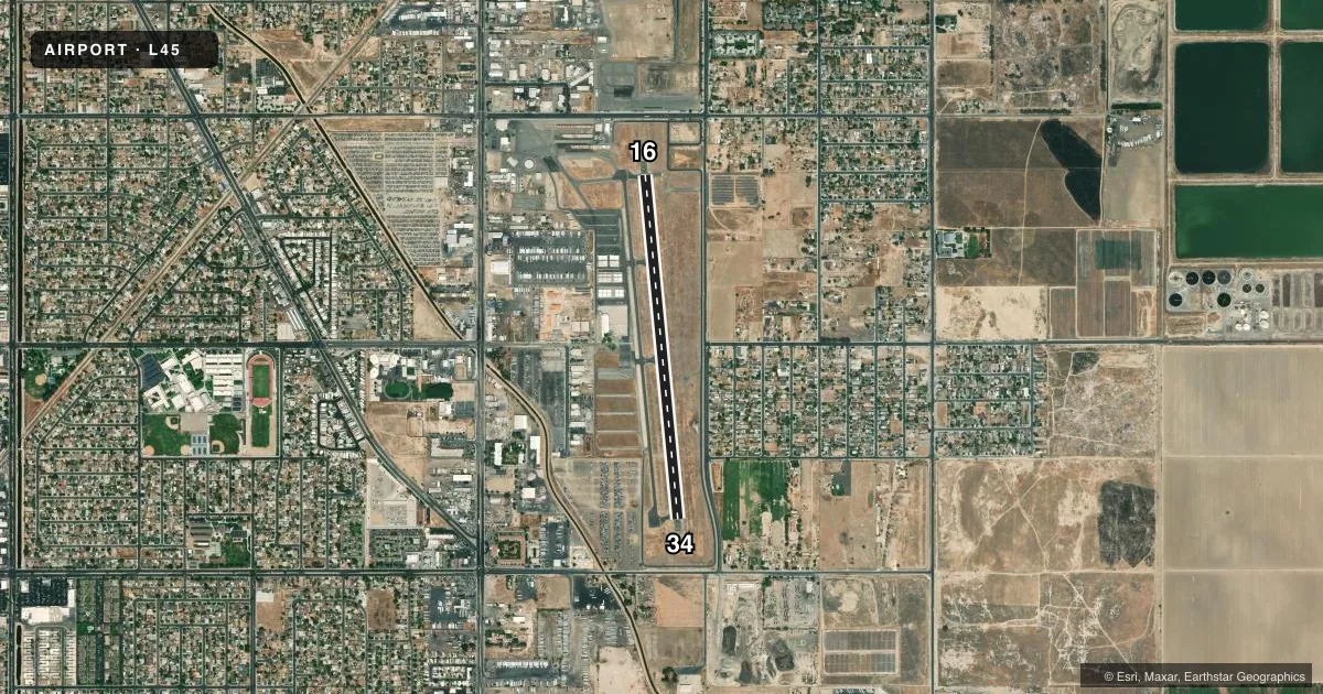
Runways & pattern
Full pagePattern entry · RWY 34
LEFT TRAFFICRunway end performance
| End | TORA | TODA | ASDA | LDA | VGSI | Approach lights | Obstruction |
|---|---|---|---|---|---|---|---|
| 16 | — | — | — | — | — | — | 15', road, 650' from thr, 170' R of cntrln, slope 30 |
| 34 | — | — | — | — | PAPI 2-box left(4.1°) | — | 103', pline, 2500' from thr, 0' R of cntrln, slope 22 |
Declared distances in feet. TORA = takeoff run available, TODA = takeoff distance, ASDA = accelerate-stop, LDA = landing distance.
Airport sketch
Runways drawn to scale from FAA survey coordinates, rendered over satellite imagery. Not for navigation.
Approaches & charts
Services on the field
Fuel grades, oxygen, maintenance, ramp storage and lighting — as declared to the FAA by the airport operator.
Fuel & services
- Fuel
- 100LLA
- Airframe repair
- Major
- Power plant repair
- Major
- Other services
- CHTR,INSTR,RNTL
Ramp & ground
- Transient storage
- Tie-down
- Landing fee
- No fee published
- Customs
- Not available
- Lighting schedule
- SEE RMK
- Beacon schedule
- SS-SR
- Beacon
- White / Green (civil land)(WG)
- Wind indicator
- Lighted
- Segmented circle
- Yes
Fuel & FBOs
Cheapest 100LL and Jet A on the field and nearby. Always confirm with the FBO before taxi.
Airport notes
Surface conditions, obstructions, local procedures, lighting outages and other notes published with each FAA cycle.
General notes
- +100 FT POLE LINE 1/2 MILE SOUTH OF ARPT.
- (E98) ALSO ONE HEX HANGER & 20 OPEN - SHADE HANGARS.
- FOR CD CTC LOS ANGELES ARTCC AT 661-575-2079.
Lighting notes
- ACTVT REIL RWY 16 AND RWY 34; MIRL RWY 16/34 - CTAF. PAPI RWY 34 OPER CONSLY. ACTVT MIRL RWY 16/34 THREE CLICKS FOR ON; LGTS GO OUT AFTER 15 MINS.
Fuel notes
- AFULL SERVICE USING FUELING TRUCK.
Runway surface & condition
- 16/34150 FT PAVED STOPWAY AT EACH END OF RWY.
Other notes
- ESTABD PRIOR TO 1959.
- MANAGEREMERGENCY 661-327-7111
VFR map & nearby airports
VFR sectional. Tap any ICAO chip to open that airport.
Key facts · L45
Answer card- ICAO
- L45
- Name
- BAKERSFIELD MUNI
- Location
- BAKERSFIELD, CALIFORNIA
- Elevation
- 378.3 ft MSL
- Traffic pattern altitude
- 1,178.3 ft MSL (800 AGL)
- Control tower
- Non-towered (use CTAF)
- Total runways
- 1
- Longest runway
- 16/34 · 4,000 ft
- Published ILS approaches
- 0
- Published frequencies
- 4
- Magnetic variation
- 14°
- Current flight rules
- VFR
- Current wind
- 320° at 6 kt
- Favored runway now
- RWY 34
Bakersfield Muni is in Bakersfield, California. The field elevation is 378.3 ft MSL. It has one runway. Runway 16/34 is 4,000 ft of asphalt, so this is a short-field airport by airline standards but workable for light aircraft and many business aircraft. There is no control tower. CTAF and UNICOM are both 122.8. Published approach support does not include an ILS, so plan with the current charted procedures and verify weather minimums before you go.
Pattern altitude is 800 ft AGL, which is 1,178.3 ft MSL. The airport uses 14° magnetic variation, so cross-check headings carefully when you brief the runway. Published remarks note runway end identifier lights on both ends of 16/34. The medium intensity runway lights are activated by CTAF. The PAPI on runway 34 operates continuously. The runway lights can also be turned on with three clicks on CTAF. There is a 150-foot paved stopway at each end of runway 16/34.
BEST Aviation is on the field. It carries AVGAS 100LL and JET A. Full service is available by fueling truck. For clearance delivery, contact Los Angeles ARTCC at the published number before departure if you need it. Pilots should also note the 100-foot pole line half a mile south of the airport.