METAR & TAF KBTY
KBTY does not publish a METAR.
Showing the nearest reporting station: KTPH (TONOPAH) · 73.4 NM away. Conditions at KBTY may differ.
METAR · KTPH
Observed 06:56Z
KTPH 270656Z AUTO 00000KT 10SM CLR 27/M02 A3015 RMK AO2 SLP107 T02721017
- Wind
- 000° @ 0 kt
- Visibility
- 10 SM
- Temp / Dew
- 27°C / -2°C
- Altimeter
- 30.15 inHg
- Clouds
- CLR
- Density alt
- 5,084 ft
- Ceiling
- Unlimited
- Rules
- VFR
Airport info & contacts
Manager on record, flight service, ARTCC, attendance schedule and pattern altitude — published by the FAA and refreshed every 28 days.
Location
- From city
- 3 NM SW
- VFR sectional
- LAS VEGAS
- ARTCC
- ZLA · LOS ANGELES
- NOTAM facility
- RNO (NOTAM-D)
Airport manager
- Name
- THOMAS BOLLING
- Phone
- 775-751-6270
- Address
- 2041 E. CALVADA BLVD. N. SUITE #3, PAHRUMP NV 89048
Flight service · Hours
- FSS RNO
- RENO1-800-WX-BRIEF
- Attendance
- Unattended
Frequencies
Tap any row to copy the frequency to your clipboard.
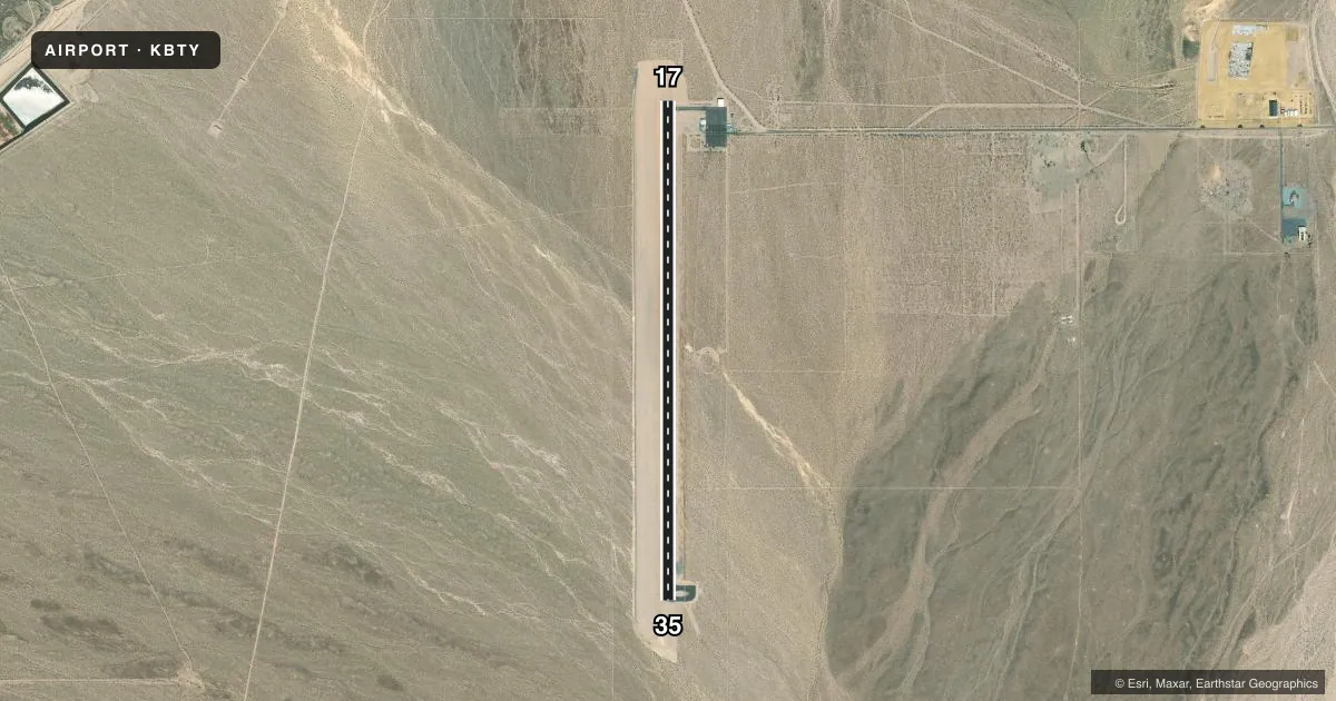
Runways & pattern
Full pagePattern entry · RWY 17
LEFT TRAFFICAirport sketch
Runways drawn to scale from FAA survey coordinates, rendered over satellite imagery. Not for navigation.
Approaches & charts
Services on the field
Fuel grades, oxygen, maintenance, ramp storage and lighting — as declared to the FAA by the airport operator.
Fuel & services
- Fuel
- 100LL
- Other services
- AMB,GLD
Ramp & ground
- Transient storage
- Tie-down
- Landing fee
- No fee published
- Customs
- Not available
- Lighting schedule
- SEE RMK
- Beacon schedule
- SS-SR
- Beacon
- White / Green (civil land)(WG)
- Wind indicator
- Yes
- Segmented circle
- Yes
Fuel & FBOs
Cheapest 100LL and Jet A on the field and nearby. Always confirm with the FBO before taxi.
Airport notes
Surface conditions, obstructions, local procedures, lighting outages and other notes published with each FAA cycle.
General notes
- LOW FLYING MIL ACFT INVOF ARPT.
- FOR CD, IF UNA TO CTC ON FSS FREQ, CTC NELLIS APCH AT 702-652-4172.
Lighting notes
- ACTVT MIRL RWY 17/35 - CTAF.
Approach & departure obstructions
- 17TRRN RISES 3:1 FOR 2 MI TO BASE OF MTN.
Other notes
- ESTABD PRIOR TO 15 MAY 1959.
VFR map & nearby airports
VFR sectional. Tap any ICAO chip to open that airport.
Key facts · KBTY
Answer card- ICAO
- KBTY
- Name
- BEATTY
- Location
- BEATTY, NEVADA
- Elevation
- 3,169 ft MSL
- Traffic pattern altitude
- 4,169 ft MSL (1,000 AGL)
- Control tower
- Non-towered (use CTAF)
- Total runways
- 1
- Longest runway
- 17/35 · 5,615 ft
- Published ILS approaches
- 0
- Published frequencies
- 1
- Magnetic variation
- 12°
- Current flight rules
- VFR
- Current wind
- 000° at 0 kt
- Favored runway now
- –
KBTY is in Beatty, Nevada. The field elevation is 3,169 ft MSL. It has one runway. Runway 16/34 is 5,615 ft long with an asphalt surface. There is no control tower. CTAF is 122.9.
No ILS approaches are published here. The pattern altitude is not published, so use the standard 1,000 ft AGL unless the current Chart Supplement says otherwise. That puts the light piston pattern at 4,169 ft MSL. The airport sits in desert terrain, so density altitude can matter on warm days. Terrain also rises to the base of the mountain off runway 16 on a 3-to-1 slope for two miles. Plan your departure and arrival with that in mind.
Published remarks also note medium intensity runway lights on 16/34. They are activated by the CTAF. Low flying military aircraft may be in the area. If you need clearance delivery and cannot reach Flight Service on the published frequency, contact Nellis Approach at 702-652-4172. No on-field FBOs are listed, so call the airport operator directly or the field on CTAF for current fuel and service availability before you go.