METAR & TAF 3Q0
3Q0 does not publish a METAR.
Showing the nearest reporting station: KHTH (HAWTHORNE INDUSTRIAL) · 27.1 NM away. Conditions at 3Q0 may differ.
METAR · KHTH
Observed 17:55Z
KHTH 261755Z AUTO VRB03KT 10SM CLR 30/M08 A3013 RMK A01
- Wind
- VAR @ 3 kt
- Visibility
- 10 SM
- Temp / Dew
- 30°C / -8°C
- Altimeter
- 30.13 inHg
- Clouds
- CLR
- Density alt
- 7,190 ft
- Ceiling
- Unlimited
- Rules
- VFR
Airport info & contacts
Manager on record, flight service, ARTCC, attendance schedule and pattern altitude — published by the FAA and refreshed every 28 days.
Location
- From city
- 0 NM SE
- VFR sectional
- SAN FRANCISCO
- ARTCC
- ZOA · OAKLAND
- NOTAM facility
- RNO (NOTAM-D)
Airport manager
- Name
- CHARLES FROST
- Phone
- 775-573-2214
- Address
- BOX 407, MINA NV 89422
Flight service · Hours
- FSS RNO
- RENO1-800-WX-BRIEF
- Attendance
- Unattended
Frequencies
Tap any row to copy the frequency to your clipboard.
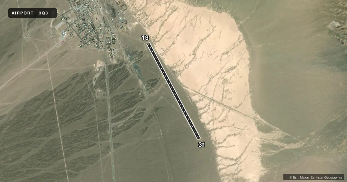
Runways & pattern
Full pagePattern entry · RWY 31
LEFT TRAFFICAirport sketch
Runways drawn to scale from FAA survey coordinates, rendered over satellite imagery. Not for navigation.
Approaches & charts
Services on the field
Fuel grades, oxygen, maintenance, ramp storage and lighting — as declared to the FAA by the airport operator.
Fuel & services
- Fuel
- Not available
- Oxygen (bottled)
- Not available
- Oxygen (bulk)
- Not available
- Airframe repair
- Not available
- Power plant repair
- Not available
Ramp & ground
- Transient storage
- Tie-down
- Landing fee
- No fee published
- Customs
- Not available
- Wind indicator
- Yes
- Segmented circle
- Yes
Fuel & FBOs
Cheapest 100LL and Jet A on the field and nearby. Always confirm with the FBO before taxi.
Airport notes
Surface conditions, obstructions, local procedures, lighting outages and other notes published with each FAA cycle.
General notes
- RY 13/31 HAS 2 FT BERMS ON BOTH SIDES FULL LENGTH OF RY.
- RY 13/31 HAS UNCONTROLLED VEHICLE ACCESS.
- ULTRALIGHTS ON & INVOF ARPT.
- REMOTE CONTROLLED AIRCRAFT INVOF ARPT.
- WILD HORSES, BURROS, AND BIG HORN SHEEP IN AIRPORT ENVIRONMENT
- TWY TO OFF RWY PRKG AREA BLOCKED BY 3 FT HIGH CATTLE GUARD RAILS THAT COULD DAMAGE LOW WING ACFT.
- FOR CD CTC OAKLAND ARTCC AT 510-745-3380.
Approach & departure obstructions
- 1313/31 THLDS MARKED WITH WHITE TIRES.
Other notes
- ESTABD PRIOR TO 5/15/59.
VFR map & nearby airports
VFR sectional. Tap any ICAO chip to open that airport.
Key facts · 3Q0
Answer card- ICAO
- 3Q0
- Name
- MINA
- Location
- MINA, NEVADA
- Elevation
- 4,557 ft MSL
- Traffic pattern altitude
- 5,557 ft MSL (1,000 AGL)
- Control tower
- Non-towered (use CTAF)
- Total runways
- 1
- Longest runway
- 13/31 · 4,600 ft
- Published ILS approaches
- 0
- Published frequencies
- 1
- Magnetic variation
- 15°
- Current flight rules
- VFR
- Current wind
- 000° at 3 kt
- Favored runway now
- RWY 31
MINA Airport (3Q0) sits in Mina, Nevada at 4,557 ft MSL. It has one runway. Runway 13/31 is 4,600 ft long and is dirt. The airport is not towered. CTAF is 122.9. No ILS approaches are published here.
Pattern altitude is not published. Use standard light piston traffic pattern planning at 1,000 ft AGL unless the current Chart Supplement says otherwise. The runway headings are magnetic. Runway 13 is 152°. Runway 31 is 332°.
There are no on-field FBOs listed. Check with the airport operator or the FBO directly by phone before arrival if you need fuel or services. Published remarks matter here. Runway 13/31 has 2-foot berms along both sides for the full length. The taxiway to off-runway parking is blocked by 3-foot cattle guard rails that could be a problem for low-wing aircraft. Ultralights and remote controlled aircraft also operate in the area. Wildlife is part of the picture too, including wild horses, burros and big horn sheep. For clearance delivery, contact Oakland ARTCC at 510-745-3380. A first-time pilot should plan for a remote field, high elevation and a dirt surface. Review the current Chart Supplement before you go.