METAR & TAF O57
O57 does not publish a METAR.
Showing the nearest reporting station: KHTH (HAWTHORNE INDUSTRIAL) · 32.5 NM away. Conditions at O57 may differ.
METAR · KHTH
Observed 07:15Z
KHTH 270715Z AUTO 32013KT 10SM CLR 27/M02 A3009 RMK A01
- Wind
- 320° @ 13 kt
- Visibility
- 10 SM
- Temp / Dew
- 27°C / -2°C
- Altimeter
- 30.09 inHg
- Clouds
- CLR
- Density alt
- 9,254 ft
- Ceiling
- Unlimited
- Rules
- VFR
Airport info & contacts
Manager on record, flight service, ARTCC, attendance schedule and pattern altitude — published by the FAA and refreshed every 28 days.
Location
- From city
- 0 NM NE
- VFR sectional
- SAN FRANCISCO
- Pattern altitude
- 700 ft AGL · 7,172 ft MSL
- ARTCC
- ZOA · OAKLAND
- NOTAM facility
- RAL (NOTAM-D)
Airport manager
- Name
- KALEN DODD
- Phone
- 760-932-5452
- Address
- P.O. BOX 457, BRIDGEPORT CA 93517
Flight service · Hours
- FSS RAL
- RIVERSIDE1-800-WX-BRIEF
- Attendance
- Unattended
Frequencies
Tap any row to copy the frequency to your clipboard.
Runways & pattern
Full pagePattern entry · RWY 34
LEFT TRAFFICRunway end performance
| End | TORA | TODA | ASDA | LDA | VGSI | Approach lights | Obstruction |
|---|---|---|---|---|---|---|---|
| 34 | — | — | — | — | — | — | 15', road, 400' from thr, 145' R of cntrln, slope 13 |
Declared distances in feet. TORA = takeoff run available, TODA = takeoff distance, ASDA = accelerate-stop, LDA = landing distance.
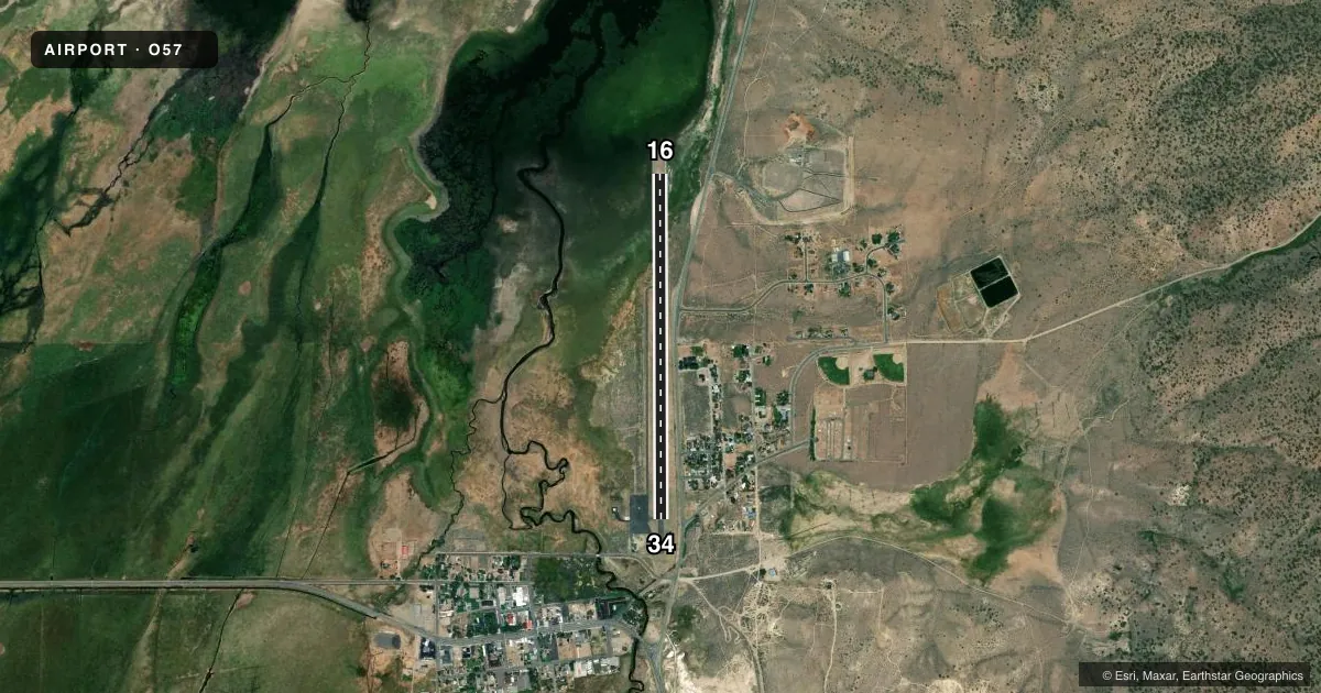
Airport sketch
Runways drawn to scale from FAA survey coordinates, rendered over satellite imagery. Not for navigation.
Approaches & charts
Services on the field
Fuel grades, oxygen, maintenance, ramp storage and lighting — as declared to the FAA by the airport operator.
Fuel & services
- Fuel
- Not available
- Oxygen (bottled)
- Not available
- Oxygen (bulk)
- Not available
- Airframe repair
- Not available
- Power plant repair
- Not available
Ramp & ground
- Transient storage
- Tie-down
- Landing fee
- No fee published
- Customs
- Not available
- Lighting schedule
- SEE RMK
- Beacon schedule
- SS-SR
- Beacon
- White / Green (civil land)(WG)
- Wind indicator
- Lighted
- Segmented circle
- Yes
Fuel & FBOs
Cheapest 100LL and Jet A on the field and nearby. Always confirm with the FBO before taxi.
Airport notes
Surface conditions, obstructions, local procedures, lighting outages and other notes published with each FAA cycle.
General notes
- BIRDS TEND TO CONGREGATE ON N END OF RY.
- ARPT LCTD IN MOUNTAINOUS TERRAIN. HILLSIDE LCTD 1644 FT EAST OF APCH END OF RWY 34 AND 1815 FT EAST OF APCH END RWY 16.
- VEHICLES ON HWY PARALLEL TO RWY 180 FT EAST OF APCH END RWY 16 TO MIDFIELD.
- SVRL UNLIT 40-80 FT TREES ARE AT 225-500 FT E OF THE RWY CNTRLN ALONG THE S TWO THIRDS OF THE RWY.
- FOR CD CTC OAKLAND ARTCC AT 510-745-3380.
Lighting notes
- ROTG BCN LOCATED 1/4 MILE E OF THE ARPT ON TOP OF HILL.
- ACTVT MIRL RWY 16/34 - 122.8.
Approach & departure obstructions
- 16PTNS OF RWY CNTRLN OBSCD BY CRACK FILL.
- 34PTNS OF RWY CNTRLN OBSCD BY CRACK FILL.
Other notes
- ESTABD PRIOR TO 15 MAY 1959.
VFR map & nearby airports
VFR sectional. Tap any ICAO chip to open that airport.
Key facts · O57
Answer card- ICAO
- O57
- Name
- BRYANT FLD
- Location
- BRIDGEPORT, CALIFORNIA
- Elevation
- 6,471.7 ft MSL
- Traffic pattern altitude
- 7,171.7 ft MSL (700 AGL)
- Control tower
- Non-towered (use CTAF)
- Total runways
- 1
- Longest runway
- 16/34 · 3,854 ft
- Published ILS approaches
- 0
- Published frequencies
- 1
- Magnetic variation
- 16°
- Current flight rules
- VFR
- Current wind
- 320° at 13 kt
- Favored runway now
- RWY 34
Bryant Fld is in Bridgeport, California. It sits at 6,471.7 ft MSL in mountainous terrain. The field has one runway. Runway 16/34 is 3,854 ft asphalt, which is the longest runway on the airport. There is no control tower. CTAF is 122.9.
Pattern altitude is 700 ft AGL. That puts the traffic pattern at 7,171.7 ft MSL. No ILS approaches are published here, so plan with the current charted procedures and the terrain in mind. The airport is high elevation. That matters for takeoff roll, climb performance and density altitude. The remarks also call out trees east of the runway centerline. They also mention vehicles on the highway east of runway 16. A hillside sits near both ends. The runway centerline markings are partly obscured by crack fill on both runway directions.
There are no on-field FBOs listed. Check the current FAA Chart Supplement or call the airport operator directly before you go if you need fuel, services, or local operating details. The field also has medium intensity runway lights on runway 16/34, with activation on frequency 122.8. Birds tend to gather on the north end of the runway, so keep a sharp scan on rollout and takeoff.