METAR & TAF O24
O24 does not publish a METAR.
Showing the nearest reporting station: KMMH (MAMMOTH YOSEMITE) · 23.7 NM away. Conditions at O24 may differ.
METAR · KMMH
Observed 06:15Z
KMMH 270615Z AUTO 00000KT 10SM CLR 20/01 A3029 RMK AO2
- Wind
- 000° @ 0 kt
- Visibility
- 10 SM
- Temp / Dew
- 20°C / 1°C
- Altimeter
- 30.29 inHg
- Clouds
- CLR
- Density alt
- 8,576 ft
- Ceiling
- Unlimited
- Rules
- VFR
Airport info & contacts
Manager on record, flight service, ARTCC, attendance schedule and pattern altitude — published by the FAA and refreshed every 28 days.
Location
- From city
- 1 NM E
- VFR sectional
- SAN FRANCISCO
- Pattern altitude
- 800 ft AGL · 7,602 ft MSL
- ARTCC
- ZOA · OAKLAND
- NOTAM facility
- RAL (NOTAM-D)
Airport manager
- Name
- KALEN DODD
- Phone
- 760-932-5452
- Address
- PO BOX 457, BRIDGEPORT CA 93517
Flight service · Hours
- FSS RAL
- RIVERSIDE1-800-WX-BRIEF
- Attendance
- Unattended
Frequencies
Tap any row to copy the frequency to your clipboard.
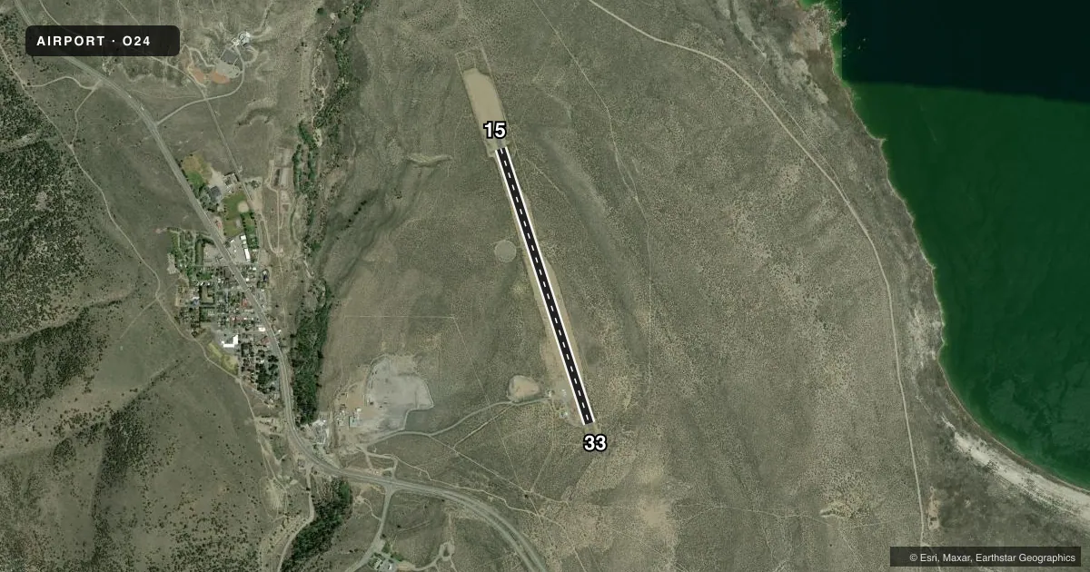
Runways & pattern
Full pagePattern entry · RWY 15
LEFT TRAFFICAirport sketch
Runways drawn to scale from FAA survey coordinates, rendered over satellite imagery. Not for navigation.
Approaches & charts
Services on the field
Fuel grades, oxygen, maintenance, ramp storage and lighting — as declared to the FAA by the airport operator.
Fuel & services
- Fuel
- Not available
- Oxygen (bottled)
- Not available
- Oxygen (bulk)
- Not available
- Airframe repair
- Not available
- Power plant repair
- Not available
Ramp & ground
- Transient storage
- Tie-down
- Landing fee
- No fee published
- Customs
- Not available
- Lighting schedule
- SEE RMK
- Beacon schedule
- SS-SR
- Beacon
- White / Green (civil land)(WG)
- Wind indicator
- Lighted
- Segmented circle
- Yes
Fuel & FBOs
Cheapest 100LL and Jet A on the field and nearby. Always confirm with the FBO before taxi.
Airport notes
Surface conditions, obstructions, local procedures, lighting outages and other notes published with each FAA cycle.
General notes
- FOR CD CTC OAKLAND ARTCC AT 510-745-3380.
Lighting notes
- ACTVT LIRL RWY 15/33 - CTAF.
Approach & departure obstructions
- 15RWY CNTRLN MRKGS ARE OBSCD BY CRACK FILL.
- 33RWY CNTRLN MRKGS ARE OBSCD BY CRACK FILL.
Other notes
- OWNERMAINTD BY MONO COUNTY.
VFR map & nearby airports
VFR sectional. Tap any ICAO chip to open that airport.
Key facts · O24
Answer card- ICAO
- O24
- Name
- LEE VINING
- Location
- LEE VINING, CALIFORNIA
- Elevation
- 6,802.2 ft MSL
- Traffic pattern altitude
- 7,602.2 ft MSL (800 AGL)
- Control tower
- Non-towered (use CTAF)
- Total runways
- 1
- Longest runway
- 15/33 · 3,920 ft
- Published ILS approaches
- 0
- Published frequencies
- 1
- Magnetic variation
- 15°
- Current flight rules
- VFR
- Current wind
- 000° at 0 kt
- Favored runway now
- –
Lee Vining Airport (O24) sits in Lee Vining, California. Field elevation is 6,802.2 ft MSL. The airport has one runway. Runway 15/33 is 3,920 ft long with asphalt pavement. The runway headings are 162° and 342° magnetic. There is no control tower. CTAF is 122.9.
Pattern altitude is 800 ft AGL, which puts the traffic pattern at 7,602.2 ft MSL. There are no ILS approaches published here. That matters in this part of California because the field is high elevation. Expect performance planning to matter on warm days. Check density altitude before you go.
Published remarks note that runway centerline markings on both ends are obscured by crack fill. The airport is maintained by Mono County. Low intensity runway lights on 15/33 are activated using CTAF. For clearance delivery, contact Oakland ARTCC at 510-745-3380. No on-field FBOs are listed, so verify services with the airport operator or call the field directly before arrival.