METAR & TAF KHTH
Current METAR
Observed 05:35Z
KHTH 260535Z AUTO 23006KT 10SM CLR 28/06 A3006 RMK A01
- Wind
- 230° @ 6 kt
- Visibility
- 10 SM
- Temp / Dew
- 28°C / 6°C
- Altimeter
- 30.06 inHg
- Clouds
- CLR
- Density alt
- 6,632 ft
- Ceiling
- Unlimited
- Rules
- VFR
Airport info & contacts
Manager on record, flight service, ARTCC, attendance schedule and pattern altitude — published by the FAA and refreshed every 28 days.
Location
- From city
- 1 NM N
- VFR sectional
- SAN FRANCISCO
- ARTCC
- ZOA · OAKLAND
- NOTAM facility
- HTH (NOTAM-D)
Airport manager
- Name
- DENNIS BUNCH
- Phone
- (775) 312-0243
- Address
- 300 O STREET, PO BOX 1035, HAWTHORNE NV 89415
Flight service · Hours
- FSS RNO
- RENO1-800-WX-BRIEF
- Attendance
- Unattended
Frequencies
Tap any row to copy the frequency to your clipboard.
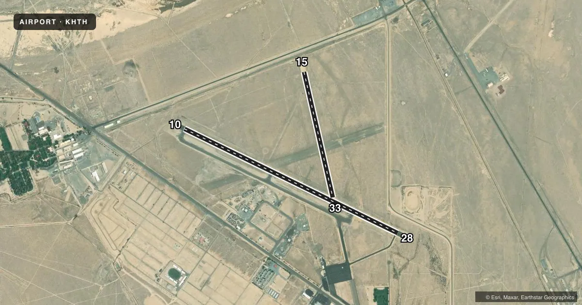
Runways & pattern
Full pagePattern entry · RWY 15
LEFT TRAFFIC| Runway | Heading (°M) | Length | Surface | Traffic |
|---|---|---|---|---|
| 10/28 | 103° / 283° | 6,000 ft | ASPH | Standard L |
| 15/33Favored | 154° / 334° | 3,250 ft | DIRT | Standard L |
Runway end performance
| End | TORA | TODA | ASDA | LDA | VGSI | Approach lights | Obstruction |
|---|---|---|---|---|---|---|---|
| 28 | — | — | — | — | PAPI 2-box left(3°) | — | — |
| 15 | — | — | — | — | — | — | 23', rr, 100' from thr, 0' R of cntrln, slope 4 |
Declared distances in feet. TORA = takeoff run available, TODA = takeoff distance, ASDA = accelerate-stop, LDA = landing distance.
Airport sketch
Runways drawn to scale from FAA survey coordinates, rendered over satellite imagery. Not for navigation.
Approaches & charts
Services on the field
Fuel grades, oxygen, maintenance, ramp storage and lighting — as declared to the FAA by the airport operator.
Fuel & services
- Fuel
- 100LLAA+
- Other services
- AMB
Ramp & ground
- Transient storage
- Tie-down
- Landing fee
- No fee published
- Customs
- Not available
- Lighting schedule
- SEE RMK
- Beacon schedule
- SS-SR
- Beacon
- White / Green (civil land)(WG)
- Wind indicator
- Lighted
- Segmented circle
- Yes
Fuel & FBOs
Cheapest 100LL and Jet A on the field and nearby. Always confirm with the FBO before taxi.
Airport notes
Surface conditions, obstructions, local procedures, lighting outages and other notes published with each FAA cycle.
General notes
- OCNL UAV/UAS ACT ON & INVOF ARPT.
- WILDLIFE ACT INVOF ARPT.
- FOR CD CTC OAKLAND ARTCC AT 510-745-3380.
Lighting notes
- ACTVT REIL RWY 10 & 28; MIRL RWY 10/28 - CTAF. PAPI RWY 28 ON CONSLY.
Approach & departure obstructions
- 33RWY BGNS AT N EDGE RWY 10/28.
- 28PAPI UNUSBL BYD 3.8 DEG RIGHT OF CNTRLN.
Other notes
- 1VOLUNTEER ATND - BETTY EASLEY (775) 945-9286.
VFR map & nearby airports
VFR sectional. Tap any ICAO chip to open that airport.
Key facts · KHTH
Answer card- ICAO
- KHTH
- Name
- HAWTHORNE INDUSTRIAL
- Location
- HAWTHORNE, NEVADA
- Elevation
- 4,230.4 ft MSL
- Traffic pattern altitude
- 5,230.4 ft MSL (1,000 AGL)
- Control tower
- Non-towered (use CTAF)
- Total runways
- 2
- Longest runway
- 10/28 · 6,000 ft
- Published ILS approaches
- 0
- Published frequencies
- 2
- Magnetic variation
- 13°
- Current flight rules
- VFR
- Current wind
- 230° at 6 kt
- Favored runway now
- RWY 15
Hawthorne Industrial Airport sits in Hawthorne, Nevada at 4,230.4 ft MSL. It has two runways. The longest is 10/28 at 6,000 ft. The field is non-towered. CTAF and UNICOM are both 122.8. No ILS approaches are published here.
The pattern altitude is not published. Use the standard 1,000 ft AGL for light piston operations unless the current Chart Supplement says otherwise. That puts the traffic pattern around 5,230.4 ft MSL. The on-field FBO is Hawthorne Industrial Airport. It carries 100LL and Jet A Prist. Call (775) 945-3897 for current service details before you go.
This is a high-elevation field, so performance planning matters. Expect density altitude to be a factor, especially on warm days. Wildlife activity is published for the airport. There is also occasional unmanned aircraft activity in and around the field. Runway 10/28 has runway end identifier lights and medium intensity runway lights controlled by CTAF. The PAPI on runway 28 is on continuously. It is unusable beyond 7 degrees right of centerline. It does not provide obstruction clearance beyond 6.0 NM from the threshold. Runway 15/33 is dirt and begins at the north edge of runway 10/28. For clearance delivery, contact Oakland ARTCC at 510-745-3380.