METAR & TAF O43
O43 does not publish a METAR.
Showing the nearest reporting station: KMEV (MINDEN-TAHOE) · 27.7 NM away. Conditions at O43 may differ.
METAR · KMEV
Observed 16:35Z
KMEV 261635Z AUTO 00000KT 10SM CLR 25/M00 A3017 RMK AO2
- Wind
- 000° @ 0 kt
- Visibility
- 10 SM
- Temp / Dew
- 25°C / 0°C
- Altimeter
- 30.17 inHg
- Clouds
- CLR
- Density alt
- 6,324 ft
- Ceiling
- Unlimited
- Rules
- VFR
Airport info & contacts
Manager on record, flight service, ARTCC, attendance schedule and pattern altitude — published by the FAA and refreshed every 28 days.
Location
- From city
- 1 NM N
- VFR sectional
- SAN FRANCISCO
- Pattern altitude
- 800 ft AGL · 5,182 ft MSL
- ARTCC
- ZOA · OAKLAND
- NOTAM facility
- RNO (NOTAM-D)
Airport manager
- Name
- PAUL SHAPIRO
- Phone
- 775-431-4534
- Address
- 14 EAST GOLDFIELD AVENUE, YERINGTON NV 89447
Flight service · Hours
- FSS RNO
- RENO1-800-WX-BRIEF
- Attendance
- MON-FRI · 0700-1800
- SAT-SUN · IREG
Frequencies
Tap any row to copy the frequency to your clipboard.
Runways & pattern
Full pagePattern entry · RWY 02
LEFT TRAFFICRunway end performance
| End | TORA | TODA | ASDA | LDA | VGSI | Approach lights | Obstruction |
|---|---|---|---|---|---|---|---|
| 02 | — | — | — | — | PAPI 2-box left(3°) | — | 35', ant, 902' from thr, 215' R of cntrln, slope 20 |
| 20 | — | — | — | — | PAPI 2-box left(3°) | — | 78', trees, 1785' from thr, 52' R of cntrln, slope 20 |
Declared distances in feet. TORA = takeoff run available, TODA = takeoff distance, ASDA = accelerate-stop, LDA = landing distance.
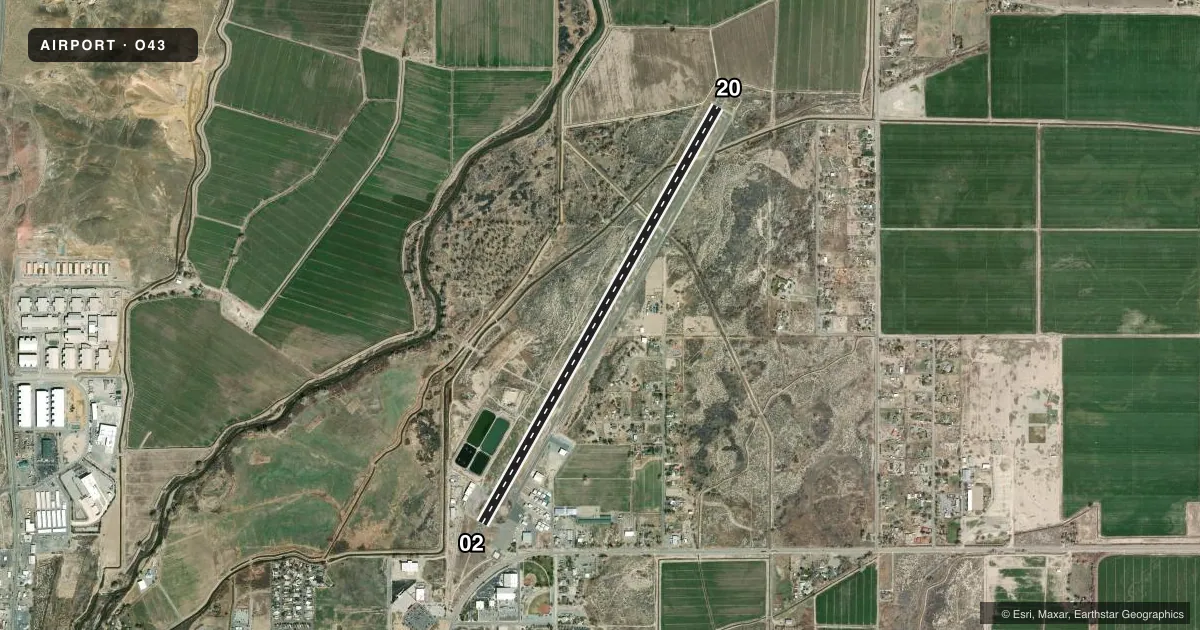
Airport sketch
Runways drawn to scale from FAA survey coordinates, rendered over satellite imagery. Not for navigation.
Approaches & charts
Services on the field
Fuel grades, oxygen, maintenance, ramp storage and lighting — as declared to the FAA by the airport operator.
Fuel & services
- Fuel
- 100LL
- Other services
- AMB
Ramp & ground
- Transient storage
- Tie-down
- Landing fee
- No fee published
- Customs
- Not available
- Lighting schedule
- SEE RMK
- Beacon schedule
- SS-SR
- Beacon
- White / Green (civil land)(WG)
- Wind indicator
- Lighted
- Segmented circle
- Yes
Fuel & FBOs
Cheapest 100LL and Jet A on the field and nearby. Always confirm with the FBO before taxi.
Airport notes
Surface conditions, obstructions, local procedures, lighting outages and other notes published with each FAA cycle.
General notes
- FOR CD CTC OAKLAND ARTCC AT 510-745-3380.
Lighting notes
- ACTVT REIL RWY 02 & 20; MIRL RWY 02/20 - CTAF. PAPI RWY 02 & 20 ON CONSLY.
Runway surface & condition
- 02/20PCR VALUE: 140/F/C/X/T
Approach & departure obstructions
- 02PAPI UNUSBL BYD 3.0 NM FM RWY THR DUE TO TRRN.
Other notes
- AUTOMATED UNICOM.
- MANAGER775-302-1155
VFR map & nearby airports
VFR sectional. Tap any ICAO chip to open that airport.
Key facts · O43
Answer card- ICAO
- O43
- Name
- YERINGTON MUNI
- Location
- YERINGTON, NEVADA
- Elevation
- 4,381.9 ft MSL
- Traffic pattern altitude
- 5,181.9 ft MSL (800 AGL)
- Control tower
- Non-towered (use CTAF)
- Total runways
- 1
- Longest runway
- 02/20 · 5,822 ft
- Published ILS approaches
- 0
- Published frequencies
- 2
- Magnetic variation
- 13°
- Current flight rules
- VFR
- Current wind
- 000° at 0 kt
- Favored runway now
- –
Yerington Muni sits in Yerington, Nevada. The field elevation is 4,381.9 ft MSL. It has one runway. Runway 02/20 is 5,822 ft long with asphalt pavement. This is a non-towered field. CTAF and UNICOM are both 122.8. The pattern altitude is 800 ft AGL, which is 5,181.9 ft MSL.
No ILS approaches are published here. The airport has runway end identifier lights. Medium intensity runway lights are on 02/20. The PAPI is on continuously. The published remarks also note that the PAPI on runway 02 is unusable beyond 3.0 NM from the threshold because of terrain. That matters if you are planning a stabilized visual approach from farther out. The pavement classification rating is 140/F/C/X/T.
Yerington Municipal Airport is on the field. It carries 100LL. If you need current ramp, fuel, or local field details, call them at (775) 463-3511. For clearance delivery, contact Oakland ARTCC at 510-745-3380. The manager’s number is 775-302-1155. Expect high-density performance planning because the airport sits above 4,300 ft MSL. Check the current FAA Chart Supplement for any local procedures before you go.