METAR & TAF A34
A34 does not publish a METAR.
Showing the nearest reporting station: KCXP (CARSON CITY) · 8.7 NM away. Conditions at A34 may differ.
METAR · KCXP
Observed 13:35Z
KCXP 271335Z AUTO 00000KT 10SM CLR 13/M02 A3018 RMK AO2
- Wind
- 000° @ 0 kt
- Visibility
- 10 SM
- Temp / Dew
- 13°C / -2°C
- Altimeter
- 30.18 inHg
- Clouds
- CLR
- Density alt
- 4,911 ft
- Ceiling
- Unlimited
- Rules
- VFR
Airport info & contacts
Manager on record, flight service, ARTCC, attendance schedule and pattern altitude — published by the FAA and refreshed every 28 days.
Location
- From city
- 2 NM E
- VFR sectional
- SAN FRANCISCO
- ARTCC
- ZOA · OAKLAND
- NOTAM facility
- RNO (NOTAM-D)
Airport manager
- Name
- DEAN PATMOR
- Phone
- (818) 519-7133
- Address
- 409 ARMSTRONG COURT, DAYTON NV 89403
Flight service · Hours
- FSS RNO
- RENO1-800-WX-BRIEF
- Attendance
- Unattended
Frequencies
Tap any row to copy the frequency to your clipboard.
Runways & pattern
Full pagePattern entry · RWY 07
RIGHT TRAFFICRunway end performance
| End | TORA | TODA | ASDA | LDA | VGSI | Approach lights | Obstruction |
|---|---|---|---|---|---|---|---|
| 07 | — | — | — | — | — | — | 193', tower, 3470' from thr, 434' R of cntrln, slope 16 |
Declared distances in feet. TORA = takeoff run available, TODA = takeoff distance, ASDA = accelerate-stop, LDA = landing distance.
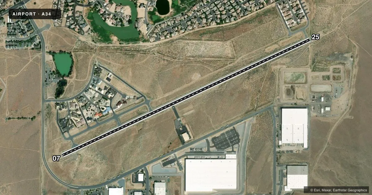
Airport sketch
Runways drawn to scale from FAA survey coordinates, rendered over satellite imagery. Not for navigation.
Approaches & charts
Services on the field
Fuel grades, oxygen, maintenance, ramp storage and lighting — as declared to the FAA by the airport operator.
Fuel & services
- Fuel
- Not available
- Other services
- AMB,INSTR
Ramp & ground
- Transient storage
- Tie-down
- Wind indicator
- Yes
- Segmented circle
- Yes
Fuel & FBOs
Cheapest 100LL and Jet A on the field and nearby. Always confirm with the FBO before taxi.
Airport notes
Surface conditions, obstructions, local procedures, lighting outages and other notes published with each FAA cycle.
General notes
- NOISE ABATEMENT: SMALL ACFT 0.75 NM S 5414 FT MSL/1000 FT AGL; JETS & LRG ACFT 1.75 NM S 6414 FT MSL/2000 FT AGL; EXTD TKOF BYD SCHOOLS & RESIDENTIAL AREAS.
- FICON & PPR - AMGR OR 575-644-2549.
- PPR OVR 12500 LBS, BANNER TOWING, SKYDIVING, UAV/UAS, PWR PRCHT & GLDR OPS - AMGR OR 575-644-2549.
- FOR CD CTC NORCAL APCH AT 916-361-0596.
- FOR GND TRANSPORTATION SVCS CALL (775) 447-3600.
- CTN: DEEP DITCH IN RSA & RWY SHOULDER SE CORNER OF RWY.
- WILD HORSES, MIGRATORY BIRDS, AND WATERFOWL ON AND INVOF ARPT.
Approach & departure obstructions
- 07198 FT UNLGTD TWR 3220 FT FM RWY END 445 FT R OF CNTRLN.
- 07APCH SLOPE 23:1 TO DSPLCD THR.
Other notes
- 7 TIE DOWNS AVBL EAST END OF ARPT ON EASTERN MOST TAXILANE WITH OVNGT FEE ON A TEMP BASIS.
VFR map & nearby airports
VFR sectional. Tap any ICAO chip to open that airport.
Key facts · A34
Answer card- ICAO
- A34
- Name
- DAYTON VALLEY AIRPARK
- Location
- DAYTON/CARSON CITY, NEVADA
- Elevation
- 4,414.3 ft MSL
- Traffic pattern altitude
- 5,414.3 ft MSL (1,000 AGL)
- Control tower
- Non-towered (use CTAF)
- Total runways
- 1
- Longest runway
- 07/25 · 5,343 ft
- Published ILS approaches
- 0
- Published frequencies
- 1
- Magnetic variation
- 16°
- Current flight rules
- VFR
- Current wind
- 000° at 0 kt
- Favored runway now
- –
Dayton Valley Airpark sits near Dayton and Carson City in Nevada. The field elevation is 4,414.3 ft MSL. It has one runway, 07/25, which is 5,343 ft long and asphalt. There is no control tower. CTAF is 122.9. No ILS approaches are published here.
Pattern altitude is not published. Use 1,000 ft AGL for light piston traffic unless the current Chart Supplement or the airport manager says otherwise. At this elevation, density altitude can matter on warm days. Expect longer takeoff rolls and a slower climb than you may see at lower fields.
Published remarks matter here. Noise abatement calls for small aircraft to stay south of the field. Jets and large aircraft have a farther south track. There is also an unlighted 198 ft tower near runway 07. A deep ditch is in the runway safety area at the southeast corner. Wildlife is part of the picture too. Wild horses, migratory birds and waterfowl are reported on and near the airport.
There are no on-field FBOs listed in the facts. Contact the airport operator directly or call the field on CTAF for current services. Seven tie-downs are available at the east end of the airport on the easternmost taxilane. For ground transportation, the published contact is available in the Chart Supplement. Clearance delivery is handled through NorCal Approach.