METAR & TAF N49
N49 does not publish a METAR.
Showing the nearest reporting station: KCXP (CARSON CITY) · 15.3 NM away. Conditions at N49 may differ.
METAR · KCXP
Observed 13:35Z
KCXP 271335Z AUTO 00000KT 10SM CLR 13/M02 A3018 RMK AO2
- Wind
- 000° @ 0 kt
- Visibility
- 10 SM
- Temp / Dew
- 13°C / -2°C
- Altimeter
- 30.18 inHg
- Clouds
- CLR
- Density alt
- 5,253 ft
- Ceiling
- Unlimited
- Rules
- VFR
Airport info & contacts
Manager on record, flight service, ARTCC, attendance schedule and pattern altitude — published by the FAA and refreshed every 28 days.
Location
- From city
- 5 NM W
- VFR sectional
- SAN FRANCISCO
- ARTCC
- ZOA · OAKLAND
- NOTAM facility
- RNO (NOTAM-D)
Airport manager
- Name
- LANCE KIDDER
- Phone
- 509-542-7838
- Address
- 15000 SENECA RD., STAGECOACH NV 89429
Flight service · Hours
- FSS RNO
- RENO1-800-WX-BRIEF
Frequencies
Tap any row to copy the frequency to your clipboard.
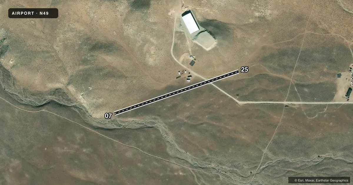
Runways & pattern
Full pagePattern entry · RWY 07
RIGHT TRAFFICRunway end performance
| End | TORA | TODA | ASDA | LDA | VGSI | Approach lights | Obstruction |
|---|---|---|---|---|---|---|---|
| 07 | — | — | — | — | — | — | 70', hill, 479' from thr, 0' R of cntrln, slope 6 |
| 25 | — | — | — | — | — | — | 176', hill, 385' from thr, 0' R of cntrln, slope 2 |
Declared distances in feet. TORA = takeoff run available, TODA = takeoff distance, ASDA = accelerate-stop, LDA = landing distance.
Airport sketch
Runways drawn to scale from FAA survey coordinates, rendered over satellite imagery. Not for navigation.
Approaches & charts
Services on the field
Fuel grades, oxygen, maintenance, ramp storage and lighting — as declared to the FAA by the airport operator.
Fuel & services
- Fuel
- Not available
Ramp & ground
- Transient storage
- Not published
- Segmented circle
- No
Fuel & FBOs
Cheapest 100LL and Jet A on the field and nearby. Always confirm with the FBO before taxi.
Airport notes
Surface conditions, obstructions, local procedures, lighting outages and other notes published with each FAA cycle.
General notes
- PPR: CALL AMGR FOR CONDS PRIOR TO FPG TO ARPT.
- RCMD RWY 25 LNDGS UPHILL & RWY 7 TKOFS DOWNHILL.
- NSTD LGT, MRKGS, & SIGNAGE.
Approach & departure obstructions
- 07ROCKS SHOW TURN AROUND AT EOR.
- 25NO RWY END MRKG.
Other notes
- 07/25SPL PILOT FAM, TRNG, EQPT, & PER RQRD FOR LNDG ON +5 PCT SLPD, ROUGH, & UNEVEN SFC RQRD.
- 07/25DIRT-GRVL.
VFR map & nearby airports
VFR sectional. Tap any ICAO chip to open that airport.
Key facts · N49
Answer card- ICAO
- N49
- Name
- ROSE QUARTZ RANCH
- Location
- STAGECOACH, NEVADA
- Elevation
- 4,690 ft MSL
- Traffic pattern altitude
- 5,690 ft MSL (1,000 AGL)
- Control tower
- Non-towered (use CTAF)
- Total runways
- 1
- Longest runway
- 07/25 · 1,350 ft
- Published ILS approaches
- 0
- Published frequencies
- 0
- Magnetic variation
- –
- Current flight rules
- VFR
- Current wind
- 000° at 0 kt
- Favored runway now
- –
Rose Quartz Ranch Airport sits in Stagecoach, Nevada. The field elevation is 4,690 ft MSL. It has one runway. Runway 07/25 is 1,350 ft long and surfaced with dirt and gravel. The runway headings are 71.188227835655° and 251.188227835655° magnetic.
There is no control tower. No ILS approaches are published. Pattern altitude is not published, so use standard traffic pattern planning at 1,000 ft AGL unless the current Chart Supplement says otherwise. At this elevation, expect higher density altitude effects on takeoff and climb performance, especially on warm days.
No on-field FBOs are listed. Plan on self-sufficiency and verify current services with the airport operator before you go. The published remark for the runway surface is simple but important. It is dirt and gravel, so braking, prop clearance and soft-field technique matter. Check the current Chart Supplement for any other operational notes before flying in.