METAR & TAF N58
N58 does not publish a METAR.
Showing the nearest reporting station: KRNO (RENO/TAHOE INTL) · 24.6 NM away. Conditions at N58 may differ.
METAR · KRNO
Observed 12:55Z
KRNO 271255Z 29005KT 10SM CLR 15/M03 A3017 RMK AO2 SLP159 T01501033
- Wind
- 290° @ 5 kt
- Visibility
- 10 SM
- Temp / Dew
- 15°C / -3°C
- Altimeter
- 30.17 inHg
- Clouds
- CLR
- Density alt
- 5,079 ft
- Ceiling
- Unlimited
- Rules
- VFR
Airport info & contacts
Manager on record, flight service, ARTCC, attendance schedule and pattern altitude — published by the FAA and refreshed every 28 days.
Location
- From city
- 3 NM S
- VFR sectional
- SAN FRANCISCO
- ARTCC
- ZOA · OAKLAND
- NOTAM facility
- RNO (NOTAM-D)
Airport manager
- Name
- JOSH GRISWALD
- Phone
- 775-471-7302
- Address
- PO BOX 283, SILVER SPRINGS NV 89429
Flight service · Hours
- FSS RNO
- RENO1-800-WX-BRIEF
- Attendance
- MON-FRI · 0700-1900
Frequencies
Tap any row to copy the frequency to your clipboard.
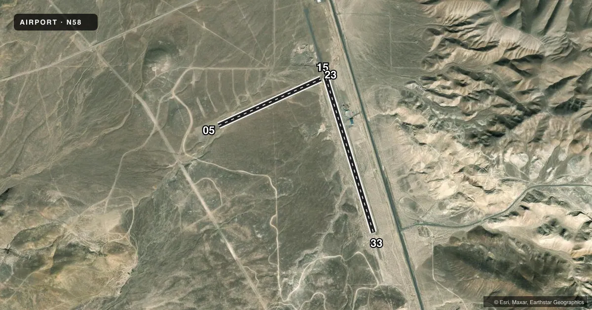
Runways & pattern
Full pagePattern entry · RWY 23
LEFT TRAFFIC| Runway | Heading (°M) | Length | Surface | Traffic |
|---|---|---|---|---|
| 15/33 | 147° / 327° | 3,974 ft | ASPH | 15 R |
| 05/23Favored | 50° / 230° | 2,750 ft | GRVL-DIRT | Standard L |
Runway end performance
| End | TORA | TODA | ASDA | LDA | VGSI | Approach lights | Obstruction |
|---|---|---|---|---|---|---|---|
| 33 | — | — | — | — | — | — | 70', hill, 1640' from thr, 0' R of cntrln, slope 20 |
| 05 | — | — | — | — | — | — | 15', road, 100' from thr, 0' R of cntrln, slope 6 |
| 23 | — | — | — | — | — | — | 440', hill, 2640' from thr, 0' R of cntrln, slope 6 |
Declared distances in feet. TORA = takeoff run available, TODA = takeoff distance, ASDA = accelerate-stop, LDA = landing distance.
Airport sketch
Runways drawn to scale from FAA survey coordinates, rendered over satellite imagery. Not for navigation.
Approaches & charts
Services on the field
Fuel grades, oxygen, maintenance, ramp storage and lighting — as declared to the FAA by the airport operator.
Fuel & services
- Fuel
- Not available
- Other services
- AMB,GLD
Ramp & ground
- Transient storage
- Tie-down
- Hangar
- Beacon schedule
- SS-SR
- Beacon
- White / Green (civil land)(WG)
- Wind indicator
- Yes
- Segmented circle
- Yes
Fuel & FBOs
Cheapest 100LL and Jet A on the field and nearby. Always confirm with the FBO before taxi.
Airport notes
Surface conditions, obstructions, local procedures, lighting outages and other notes published with each FAA cycle.
General notes
- FOR CD CTC NORCAL APCH AT 916-361-0596.
- ARPT FRQLY CLSD FOR MODEL ACFT; REMOTE ACFT OPS ON & INVOF ARPT; RDO USE ENCOURAGED.
- HEL TRG RSTRD TO PAVED RWY ENDS; LIMIT TAXI & HOVER PRAC TO RAMP AREAS.
- HORSE & CATTLE FRQLY ON & INVOF RWYS & TWYS.
- 1740 FT OVRN NW OF RWY 15 END NOT ARPT PROPERTY; MAY BE MISTAKEN FOR DSPLCD THR.
Runway surface & condition
- 05/23EFF GRADIENT 4 PERCENT W; DEP RWY 05 & ARR RWY 23 DUE TO SLP.
- 15/33EFF GRADIENT 2 PERCENT S.
Approach & departure obstructions
- 33+4 FT FENCE 75 FT FM THR.
Other notes
- PROVIDED VFR OPNS ONLY; ARPT REINSPECTED AFTER RY & OTHER MOVEMENT AREAS COMPLETED.
- 1MON-FRI
- OWNERBUREAU OF LAND MGMT - 775-861-6400
- 05/23MNT WET WX RWY CONDS - AMGR.
- 15/332-4 FT DITCHES IN PRI SFC & RWY SAFETY AREA PARALLEL TO RWY 10 FT FM RWY EDGE.
VFR map & nearby airports
VFR sectional. Tap any ICAO chip to open that airport.
Key facts · N58
Answer card- ICAO
- N58
- Name
- SAMSARG FLD
- Location
- FERNLEY, NEVADA
- Elevation
- 4,346 ft MSL
- Traffic pattern altitude
- 5,346 ft MSL (1,000 AGL)
- Control tower
- Non-towered (use CTAF)
- Total runways
- 2
- Longest runway
- 15/33 · 3,974 ft
- Published ILS approaches
- 0
- Published frequencies
- 1
- Magnetic variation
- 16°
- Current flight rules
- VFR
- Current wind
- 290° at 5 kt
- Favored runway now
- RWY 23
SAMSARG FLD is in Fernley, Nevada. The field elevation is 4,346 ft MSL. It has two runways. The longest is runway 15/33 at 3,974 ft. There is no control tower. CTAF is 122.9.
No ILS approaches are published here. Pattern altitude is not published in the facts, so use the current FAA Chart Supplement before you go. This is a VFR-only field per the published remarks. The airport is at higher elevation, so expect thinner performance than a low desert strip. Runway 05/23 has a 4 percent west gradient. That matters on takeoff and landing. Runway 15/33 also has published surface issues near the edge, plus a fence close to the threshold of runway 33.
There are no on-field FBOs listed in the facts. Contact the airport operator directly or call the field on CTAF for current services. The published remarks also say horses and cattle are often nearby. Remote model aircraft operations are frequent. Radio calls are encouraged. Helicopter training is limited to the paved runway ends. For clearance delivery, contact NorCal Approach. If you are planning a first arrival, review the current Chart Supplement for any operational notes before departure.