METAR & TAF KLOL
Current METAR
Observed 12:53Z
KLOL 271253Z AUTO 00000KT 10SM CLR 14/M04 A3009 RMK AO2 SLP148 T01391039
- Wind
- 000° @ 0 kt
- Visibility
- 10 SM
- Temp / Dew
- 14°C / -4°C
- Altimeter
- 30.09 inHg
- Clouds
- CLR
- Density alt
- 4,515 ft
- Ceiling
- Unlimited
- Rules
- VFR
Airport info & contacts
Manager on record, flight service, ARTCC, attendance schedule and pattern altitude — published by the FAA and refreshed every 28 days.
Location
- From city
- 8 NM SW
- VFR sectional
- KLAMATH FALLS
- Pattern altitude
- 800 ft AGL · 4,708 ft MSL
- ARTCC
- ZOA · OAKLAND
- NOTAM facility
- LOL (NOTAM-D)
Airport manager
- Name
- CHUCK SAYLES
- Phone
- 775-304-2010
- Address
- P. O. BOX DRAWER E, LOVELOCK NV 89419
Flight service · Hours
- FSS RNO
- RENO1-800-WX-BRIEF
- Attendance
- Unattended
Frequencies
Tap any row to copy the frequency to your clipboard.
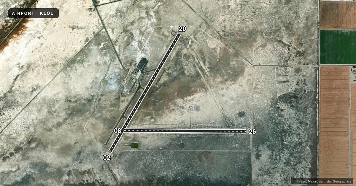
Runways & pattern
Full pagePattern entry · RWY 02
LEFT TRAFFIC| Runway | Heading (°M) | Length | Surface | Traffic |
|---|---|---|---|---|
| 02/20 | 16° / 196° | 5,529 ft | ASPH | Standard L |
| 08/26 | 76° / 256° | 4,931 ft | ASPH | Standard L |
Runway end performance
| End | TORA | TODA | ASDA | LDA | VGSI | Approach lights | Obstruction |
|---|---|---|---|---|---|---|---|
| 02 | — | — | — | — | PAPI 2-box left(3°) | — | — |
| 20 | — | — | — | — | PAPI 2-box left(3°) | — | 4', fence, 300' from thr, 0' R of cntrln, slope 25 |
| 26 | — | — | — | — | — | — | 5', fence, 250' from thr, 0' R of cntrln, slope 10 |
Declared distances in feet. TORA = takeoff run available, TODA = takeoff distance, ASDA = accelerate-stop, LDA = landing distance.
Airport sketch
Runways drawn to scale from FAA survey coordinates, rendered over satellite imagery. Not for navigation.
Approaches & charts
Services on the field
Fuel grades, oxygen, maintenance, ramp storage and lighting — as declared to the FAA by the airport operator.
Fuel & services
- Fuel
- 100LL
- Oxygen (bottled)
- Not available
- Oxygen (bulk)
- Not available
- Other services
- AMB
Ramp & ground
- Transient storage
- Tie-down
- Landing fee
- No fee published
- Customs
- Not available
- Lighting schedule
- SEE RMK
- Beacon schedule
- SS-SR
- Beacon
- White / Green (civil land)(WG)
- Wind indicator
- Yes
- Segmented circle
- Yes
Fuel & FBOs
Cheapest 100LL and Jet A on the field and nearby. Always confirm with the FBO before taxi.
Airport notes
Surface conditions, obstructions, local procedures, lighting outages and other notes published with each FAA cycle.
General notes
- TWY CLSD PERMLY.
Lighting notes
- ACTVT REIL RWY 02 & 20, MIRL RWY 02/20 - CTAF.
Fuel notes
- 100LL24 HR SELF-SERVICE
Runway surface & condition
- 02/20NO LINE OF SIGHT BTN RWYS.
Approach & departure obstructions
- 083 FT BERM 175 FT FM EOR.
Other notes
- ESTABLISHED PRIOR TO 5/15/59
VFR map & nearby airports
VFR sectional. Tap any ICAO chip to open that airport.
Key facts · KLOL
Answer card- ICAO
- KLOL
- Name
- DERBY FLD
- Location
- LOVELOCK, NEVADA
- Elevation
- 3,907.6 ft MSL
- Traffic pattern altitude
- 4,707.6 ft MSL (800 AGL)
- Control tower
- Non-towered (use CTAF)
- Total runways
- 2
- Longest runway
- 02/20 · 5,529 ft
- Published ILS approaches
- 0
- Published frequencies
- 2
- Magnetic variation
- 14°
- Current flight rules
- VFR
- Current wind
- 000° at 0 kt
- Favored runway now
- –
Derby Field sits in Lovelock, Nevada. Field elevation is 3,907.6 ft MSL. The airport has two asphalt runways. The longest is runway 02/20 at 5,529 ft. There is no control tower. CTAF and UNICOM are both 122.8. No ILS approaches are published here.
Pattern altitude is 800 ft AGL. That puts the traffic pattern at 4,707.6 ft MSL. Runway 02 and runway 20 have REIL lighting. They also have medium intensity runway lighting. The airport remarks say there is no line of sight between runways 02 and 20. The taxiway is permanently closed, so plan your ground movement carefully and verify current airport procedures before you taxi.
Derby Field FBO is on the field. It carries 100LL. 24-hour self-serve 100LL is available. The airport is at a high desert elevation, so performance planning matters. Check density altitude before departure. There is also a 3-foot berm 175 feet from the end of runway 08, so pay attention on that end of the field. If you need more detail on local procedures or any current restrictions, call the airport operator or the FBO directly before arrival.