METAR & TAF M45
M45 does not publish a METAR.
Showing the nearest reporting station: KTVL (LAKE TAHOE) · 14.3 NM away. Conditions at M45 may differ.
METAR · KTVL
Observed 06:53Z
KTVL 270653Z AUTO 00000KT 10SM CLR 12/02 A3027 RMK AO2 SLP187 T01220017
- Wind
- 000° @ 0 kt
- Visibility
- 10 SM
- Temp / Dew
- 12°C / 2°C
- Altimeter
- 30.27 inHg
- Clouds
- CLR
- Density alt
- 6,487 ft
- Ceiling
- Unlimited
- Rules
- VFR
Airport info & contacts
Manager on record, flight service, ARTCC, attendance schedule and pattern altitude — published by the FAA and refreshed every 28 days.
Location
- From city
- 3 NM N
- VFR sectional
- SAN FRANCISCO
- Pattern altitude
- 800 ft AGL · 6,672 ft MSL
- ARTCC
- ZOA · OAKLAND
- NOTAM facility
- RNO (NOTAM-D)
Airport manager
- Name
- SAM BOOTH
- Phone
- 530-694-2140
- Address
- 50 DIAMOND VALLEY RD, MARKLEEVILLE CA 96120
Flight service · Hours
- FSS RNO
- RENO1-800-WX-BRIEF
- Attendance
- Unattended
Frequencies
Tap any row to copy the frequency to your clipboard.
Runways & pattern
Full pagePattern entry · RWY 17
LEFT TRAFFICRunway end performance
| End | TORA | TODA | ASDA | LDA | VGSI | Approach lights | Obstruction |
|---|---|---|---|---|---|---|---|
| 17 | — | — | — | — | — | — | 150', hill, 3200' from thr, 425' R of cntrln, slope 20 |
Declared distances in feet. TORA = takeoff run available, TODA = takeoff distance, ASDA = accelerate-stop, LDA = landing distance.
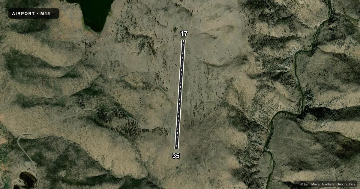
Airport sketch
Runways drawn to scale from FAA survey coordinates, rendered over satellite imagery. Not for navigation.
Approaches & charts
Services on the field
Fuel grades, oxygen, maintenance, ramp storage and lighting — as declared to the FAA by the airport operator.
Fuel & services
- Fuel
- Not available
- Oxygen (bottled)
- Not available
- Oxygen (bulk)
- Not available
- Airframe repair
- Not available
- Power plant repair
- Not available
Ramp & ground
- Transient storage
- Tie-down
- Landing fee
- No fee published
- Customs
- Not available
- Wind indicator
- Yes
- Segmented circle
- Yes
Fuel & FBOs
Cheapest 100LL and Jet A on the field and nearby. Always confirm with the FBO before taxi.
Airport notes
Surface conditions, obstructions, local procedures, lighting outages and other notes published with each FAA cycle.
General notes
- LARGE STONES ALONG EDGE OF RWY OFF GRADED SFC.
- NO SNOW REMOVAL, ARPT CLOSED WHEN SNOW ON RUNWAY.
- TREES PENETRATING TRANSITIONAL SFCS E & W OF RY.
- SOIL CONDITIONS OFF RY IS POOR IN WET CONDITIONS. CALL PUBLIC WORKS FOR ADDITIONAL INFORMATION 530-694-2140 EXT."0".
- RY 17/35 LIMITED BY AIRPORT OPERATOR TO 4,800 LBS SINGLE WHEEL, 9,600 LBS DUAL WHEEL.
- FOR CD CTC OAKLAND ARTCC AT 510-745-3380.
Other notes
- THIS AIRPORT HAS BEEN SURVEYED BY THE NATIONAL GEODETIC SURVEY.
- MANAGERDIRECTOR OF COMMUNITY DEVELOPMENT
- MANAGERX 425
- 17/35LOOSE GRVL ON RWY.
VFR map & nearby airports
VFR sectional. Tap any ICAO chip to open that airport.
Key facts · M45
Answer card- ICAO
- M45
- Name
- ALPINE COUNTY
- Location
- MARKLEEVILLE, CALIFORNIA
- Elevation
- 5,871.7 ft MSL
- Traffic pattern altitude
- 6,671.7 ft MSL (800 AGL)
- Control tower
- Non-towered (use CTAF)
- Total runways
- 1
- Longest runway
- 17/35 · 4,443 ft
- Published ILS approaches
- 0
- Published frequencies
- 1
- Magnetic variation
- 16°
- Current flight rules
- VFR
- Current wind
- 000° at 0 kt
- Favored runway now
- –
Alpine County Airport sits in Markleeville, California. Field elevation is 5,871.7 ft MSL. The airport has one runway, 17/35, which is 4,443 ft long and asphalt. It is an uncontrolled field. CTAF is 122.9. No ILS approaches are published here. Pattern altitude is 800 ft AGL. That is 6,671.7 ft MSL.
This is a high-elevation mountain airport. Expect performance to matter. The published remarks call out trees that penetrate the transitional surfaces east and west of the runway. They also note large stones along the edge of the runway off the graded surface. Loose gravel is reported on runway 17/35. The airport operator limits runway use to 4,800 pounds single wheel and 9,600 pounds dual wheel. There is no snow removal. The airport is closed when snow is on the runway.
No on-field FBOs are listed. Check with the airport operator or the FBO directly by phone before arrival if you need fuel or services. For clearance delivery, contact Oakland ARTCC. First-time pilots should plan for mountain weather, density altitude and runway surface conditions before committing to the landing.