METAR & TAF KTVL
Current METAR
Observed 12:53Z
KTVL 271253Z AUTO 18003KT 10SM CLR 05/00 A3025 RMK AO2 SLP195 T00500000
- Wind
- 180° @ 3 kt
- Visibility
- 10 SM
- Temp / Dew
- 5°C / 0°C
- Altimeter
- 30.25 inHg
- Clouds
- CLR
- Density alt
- 6,164 ft
- Ceiling
- Unlimited
- Rules
- VFR
Airport info & contacts
Manager on record, flight service, ARTCC, attendance schedule and pattern altitude — published by the FAA and refreshed every 28 days.
Location
- From city
- 3 NM SW
- VFR sectional
- SAN FRANCISCO
- ARTCC
- ZOA · OAKLAND
- NOTAM facility
- TVL (NOTAM-D)
Airport manager
- Name
- JOHN DICKINSON
- Phone
- 530-542-6182
- Address
- 1901 LISA MALOFF WAY, SUITE 100, SOUTH LAKE TAHOE CA 96150
Flight service · Hours
- FSS RNO
- RENO1-800-WX-BRIEF
- Attendance
- 0700-1600
Frequencies
Tap any row to copy the frequency to your clipboard.
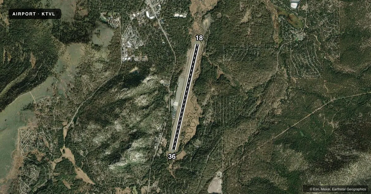
Runways & pattern
Full pagePattern entry · RWY 18
LEFT TRAFFICRunway end performance
| End | TORA | TODA | ASDA | LDA | VGSI | Approach lights | Obstruction |
|---|---|---|---|---|---|---|---|
| 18 | 8,541' | 8,541' | 7,817' | 7,017' | PAPI 4-box left(3°) | MALSF | 13', brush, 450' from thr, 125' R of cntrln, slope 19 |
| 36 | 8,541' | 8,541' | 7,741' | 5,708' | — | — | 345', trees, 5700' from thr, 500' R of cntrln, slope 15 |
Declared distances in feet. TORA = takeoff run available, TODA = takeoff distance, ASDA = accelerate-stop, LDA = landing distance.
Airport sketch
Runways drawn to scale from FAA survey coordinates, rendered over satellite imagery. Not for navigation.
Approaches & charts
ILS · 1
Services on the field
Fuel grades, oxygen, maintenance, ramp storage and lighting — as declared to the FAA by the airport operator.
Fuel & services
- Fuel
- 100LLA
- Oxygen (bottled)
- High pressure
- Oxygen (bulk)
- High pressure
- Airframe repair
- Minor
- Power plant repair
- Minor
- Other services
- CHTR,INSTR,SALES
Ramp & ground
- Transient storage
- Not published
- Landing fee
- No fee published
- Customs
- Not available
- Lighting schedule
- SEE RMK
- Beacon schedule
- SS-SR
- Beacon
- White / Green (civil land)(WG)
- Wind indicator
- Lighted
- Segmented circle
- Yes
Fuel & FBOs
Cheapest 100LL and Jet A on the field and nearby. Always confirm with the FBO before taxi.
Airport notes
Surface conditions, obstructions, local procedures, lighting outages and other notes published with each FAA cycle.
General notes
- AP SFC CONDS: TRML APRON EXCELLENT, TWY - RWY GOOD, NORTH GA APRON POOR.
- TPA 7500' MSL FOR SMALL ACFT; 8000' MSL FOR TRANSPORT/HIGH PERFORMANCE ACFT.
- AFTER WINTER STORMS RY 18/36 OPENS BEFORE ALL TWYS ARE CLEAR.
- PREFERRED ARRIVAL RY 18; PREFERRED DEP RY 36.
- RECREATIONAL AIRBORNE ACTIVITY ALONG SOUTHERN LAKE SHORE.
- (E81) APRON ENTRANCE TWYS AND HIGH SPEED TWYS ONLY.
- FOR LARGE AND HIGH PERFORMANCE ACFT DEP RY 18; RIGHT DOWNWIND DEP RECOMMENDED.
- BIRDS AND WATERFOWL INVOF ARPT.
- ADVERSE WEATHER EFFECTS MAGNIFIED BY MOUNTAINS.
- TFC ADVISORIES & SEQUENCING IN THE TFC PAT ARE BASED ON POSITION REPORTS RECEIVED FROM PILOTS IN THESE AREAS.
- ARPT SURROUNDED ON E; S & W BY RAPIDLY RISING TERRAIN.
- ACCESS NOISE RESTRICTIONS: MAX 80 DBA DEP, 84 DBA ARR (TRANSPORT - 86 DBA), MAX 77.1 DBA NIGHT LIMIT.
- NOISE ABATEMENT, DEP RWY 36 HDG 1 MILE, LEFT 320 DEG TO SHORELINE.
- FOR NOISE ABATEMENT INFO CALL (530) 542-6182.
- AVOID DESOLATION WILDERNESS WEST OF ARPT.
- AP CONDS NOT MMT 1600-0700 DLY.
- PARAGLIDERS AND MOTORIZED PRCHTS OPR FROM RWY SFC.
- AP CONDS NOT MNT SAT/SUN.
- COLD TEMPERATURE AIRPORT. ALTITUDE CORRECTION REQUIRED AT OR BELOW -12C.
Lighting notes
- ACTVT MALSF RWY 18; MIRL RWY 18/36 - CTAF. PAPI RWY 18 ON CONSLY.
Approach & departure obstructions
- 18UNUSBL BYD 4 DEG LEFT OF RWY CNTRLN & BYD 5 NM.
- 36APCH RATIO 22:1 TO DSPLCD THLD.
Other notes
- MULTICOM 122.85
VFR map & nearby airports
VFR sectional. Tap any ICAO chip to open that airport.
Key facts · KTVL
Answer card- ICAO
- KTVL
- Name
- LAKE TAHOE
- Location
- SOUTH LAKE TAHOE, CALIFORNIA
- Elevation
- 6,268.4 ft MSL
- Traffic pattern altitude
- 7,268.4 ft MSL (1,000 AGL)
- Control tower
- Non-towered (use CTAF)
- Total runways
- 1
- Longest runway
- 18/36 · 8,541 ft
- Published ILS approaches
- 1
- Published frequencies
- 1
- Magnetic variation
- 16°
- Current flight rules
- VFR
- Current wind
- 180° at 3 kt
- Favored runway now
- RWY 18
Lake Tahoe Airport (KTVL) sits in South Lake Tahoe, California. Field elevation is 6,268.4 ft MSL. The airport has one runway, 18/36, which is 8,541 ft long. There is no control tower. CTAF is 122.85. One ILS approach is published for runway 18.
Traffic pattern altitude is 7,500 ft MSL for small aircraft. It is 8,000 ft MSL for transport and high performance aircraft. Mountain West Aviation is on the field. It carries AVGAS 100LL, JET A and JET A PRIST. Call them at (530) 541-2110 for current service details.
This is a mountain airport. Adverse weather effects are magnified by the terrain. The airport is surrounded on the east, south and west by rapidly rising terrain. Avoid the Desolation Wilderness west of the airport. Birds and waterfowl are also in the area. Paragliders and motorized parachutes operate from the runway surface. After winter storms, runway 18/36 may open before all taxiways are clear. The preferred arrival runway is 18. The preferred departure runway is 36. For large and high performance aircraft, runway 18 is the recommended departure runway. Right downwind departure is recommended. First-time pilots should plan carefully for density altitude, terrain and winter surface conditions before they go.